
Founded December 11, 1818 Area 2,411 km² Unemployment rate 5.7% (Apr 2015) | Congressional district 3rd Website www.franklinmo.org Population 101,816 (2013) | |
 | ||
Destinations Colleges and Universities East Central College, Cosmetology College of Franklin, Four Rivers Career Center | ||
Franklin County is a county located in the U.S. state of Missouri. As of the 2010 census, the population was 101,492. Its county seat is Union. The county was organized in 1818 and is named after Founding Father Benjamin Franklin.
Contents
- Map of Franklin County MO USA
- History
- Geography
- Adjacent counties
- Major highways
- Demographics
- Economy
- Education
- References
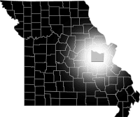
Map of Franklin County, MO, USA
Franklin County is part of the St. Louis, MO-IL Metropolitan Statistical Area and contains many of the city's exurbs. It is located along the south side of the Missouri River.
The county has wineries that are included in the Hermann AVA (American Viticultural Area) and is part of the region known as the Missouri Rhineland, which extends on both sides of the Missouri River.
History
Occupied by succeeding cultures of indigenous peoples, this area was populated by the historic Osage tribe at the time of European encounter. The region was first settled by Europeans during the rule of the Spanish Empire. The Spanish log fort San Juan del Misuri (1796–1803) was built in present-day Washington. After the American Revolutionary War, migrants from the new United States started moving West. Among them were the family and followers of Daniel Boone, an explorer from Kentucky who settled the area starting in 1799. For the next two decades, most settlers came from the Upper South, especially Kentucky and Virginia, bringing their slaves with them to work the land.
In 1833 substantial numbers of German immigrant families settled in the area, and soon they outnumbered the slaveowners. The Germans opposed slavery, and their descendants became strong supporters of the Union during the U.S. Civil War. The Confederate General Sterling Price led his troops in ransacking this area during the war when guerrilla warfare engulfed many areas of the state.
Before the war the county was served by steamboats moving freight and passenger traffic on the Missouri River. Later it also became a railroad transportation center. Manufacturing industries were established at the end of the Civil War and successive ones have continued.
Bias Vineyard, near the small city of Berger, is located within the Hermann American Viticultural Area (AVA), designated in 1983. Röbller Vineyard and Winery near New Haven is also in the Hermann AVA. Wineries along both sides of the Missouri River are part of the Missouri Rhineland, whose vineyards were started by German immigrants in the mid-19th century. Before Prohibition, Missouri was the second-largest wine-producing state in the nation. Everything was closed down except for limited production of wine allowed for religious purposes. The state's wine industry had to be completely rebuilt, which has been taking place since the 1960s.
The rural county has had severe problems with local production, distribution and consumption of methamphetamine. The struggles of the county with adverse effects of the drug, was explored in a 2005 A&E documentary entitled Meth: A County in Crisis.
Geography
According to the U.S. Census Bureau, the county has a total area of 931 square miles (2,410 km2), of which 923 square miles (2,390 km2) is land and 8.0 square miles (21 km2) (0.9%) is water. It is the fourth-largest county in Missouri by land area and third-largest by total area.
The center of the Missouri River forms the nominal northern border of the county, although the river has changed its course since boundaries were first established: a portion of St. Charles County near St. Albans is now south of the river, while a portion of Franklin County near Augusta is north of the river.
The Bourbeuse River runs for 107 miles in the county. It cuts a deep, narrow valley and is very crooked. It empties into the Meramec River near Union. This river is mostly undeveloped, with limited access and few bridges over it. During low water, a number of fords allow crossing.
The county is located in the Ozarks region, with steep hills and deep valleys, caves, springs, and sinkholes characteristic of karst areas. The underlying rock is typically carbonate, including limestone and dolomite. Mining activity in the county included ores of lead, copper, zinc, and deposits of refractory clay. The soils in most of the county tend to be thin, rocky red clay, and are poor for most agriculture, while the soil near the Missouri River is dark, rich, and thick, and used primarily for row crops such as corn, wheat, and soybeans. Much of the county is covered with thick forests, reestablished since in the 1920s.
Urbanization is increasing in the county, especially surrounding Washington and Union, and along Interstate 44. St. Albans is now a continuation of the suburban region of St. Louis County while the majority of the county retains a rural character and includes extensive wilderness areas, typical of exurban areas.
Adjacent counties
Major highways
Demographics
As of the census of 2000, there were 93,807 people, 34,945 households, and 25,684 families residing in the county. The population density was 102 people per square mile (39/km²). There were 38,295 housing units at an average density of 42 per square mile (16/km²). The racial makeup of the county was 97.47% White, 0.94% Black or African American, 0.27% Asian, 0.24% Native American, 0.02% Pacific Islander, 0.20% from other races, and 0.86% from two or more races. Approximately 0.72% of the population were Hispanic or Latino of any race. 44.9% were of German, 13.0% American, 10.7% Irish and 7.7% English ancestry.
There were 34,945 households out of which 36.10% had children under the age of 18 living with them, 60.40% were married couples living together, 9.00% had a female householder with no husband present, and 26.50% were non-families. 22.10% of all households were made up of individuals and 8.90% had someone living alone who was 65 years of age or older. The average household size was 2.66 and the average family size was 3.11.
In the county, the population was spread out with 27.40% under the age of 18, 8.20% from 18 to 24, 30.00% from 25 to 44, 22.40% from 45 to 64, and 12.10% who were 65 years of age or older. The median age was 36 years. For every 100 females there were 98.50 males. For every 100 females age 18 and over, there were 95.80 males.
The median income for a household in the county was $54,392, and the median income for a family was $62,969. Males had a median income of $35,849 versus $23,344 for females. The per capita income for the county was $24,529. About 4.50% of families and 7.00% of the population were below the poverty line, including 7.90% of those under age 18 and 8.80% of those age 65 or over.
Economy
The unemployment rate in Franklin County is 10.6% as of August, 2010, above state and national averages.
Manufacturing accounts for the most (23.8%) employment in Franklin County, primarily in the city of Washington, followed by trade, transportation and utilities (18.8%), education and health care (17.7%), and construction (11.3%).
The biggest employers in Franklin County are the manufacturing firms of Magnet LLC, Cardinal Brands Hazel Division, GDX Automotive, Sporlan Valve Company, and Meramec Group Inc. as well as the Meramec Valley R-III School District in the public education sector and Schatz Underground Cable Inc. in the construction industry. Small farms and wineries also greatly contribute to the economy in Franklin County.
Education
The highest educational attainment in Franklin County consists of the following: