
Existed: 1956 – present Length 471.8 km | Constructed 1956 | |
 | ||
West end: I‑44 / Will Rogers Turnpike near Joplin | ||
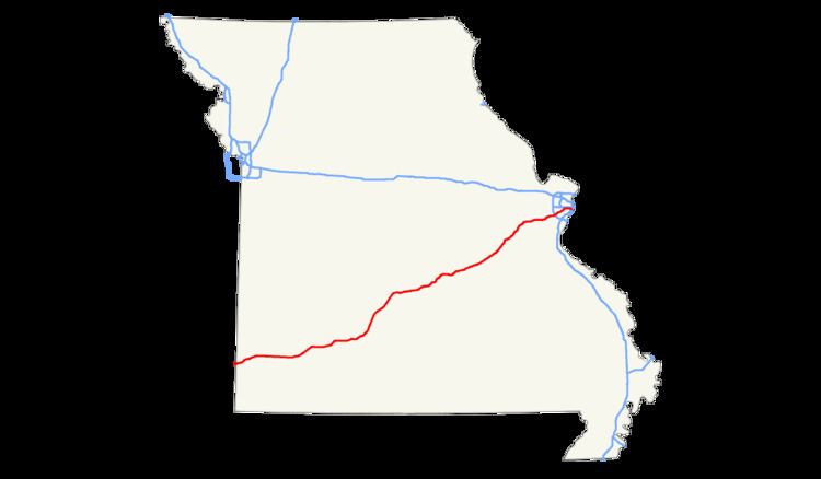
Interstate 44 (I-44) in the U.S. state of Missouri runs northeast from the Oklahoma state line near Joplin to I-70 in downtown St. Louis. It runs for about 293 miles (472 km) in the state.
Contents
Route description
Interstate 44 enters Missouri in Newton County at the eastern terminus of the Will Rogers Turnpike, 200 yards south of the Kansas state line. The first interchange in Missouri is the eastern terminus of both U.S. Highway 166 and U.S. Highway 400. This highway next goes through southern Joplin and then begins a concurrency with Interstate 49/U.S. Highway 71 at Exit 11 just after entering Jasper County. The freeway turns to a more easterly heading (the old route of US 166), and then I-49/U.S. 71 splits off to the north at Exit 18.
I-44 next enters Lawrence County. Near Mount Vernon, the highway curves to the northeast. The section of highway to Halltown is a completely new highway, not supplanting any previous highways. At Halltown, the road curves back to due east, beginning to follow the general pathway of old U.S. Highway 66, which it does all the way to downtown St. Louis. I-44 then goes around the western and northern sides of Springfield, serving as the western terminus of the James River Freeway, as well as crossing both Route 13 and U.S. Highway 65. The Interstate Highway continues northeast, bypassing Lebanon.
In Pulaski County, I-44 enters the Mark Twain National Forest, and then leaves it to provide access to Waynesville, St. Robert, and Fort Leonard Wood, before re-entering the national forest. The freeway leaves the forest in Phelps County west of Rolla. I-44 then goes through Rolla, where it meets U.S. Highway 63. It continues its northeast course, passing near St. James, Cuba, Bourbon, Sullivan, and Saint Clair.
I-44 next goes north of Pacific before moving into St. Louis County. I-44 then bisects Eureka before serving as the southern boundary of Route 66 State Park (the former site of Times Beach, known for its dioxin contamination and its eventual demolition and Superfund cleanup). I-44 then runs across unincorporated land before entering Fenton and having an interchange with Interstate 270 in Sunset Hills. I-44 then goes through Crestwood, Kirkwood, Oakland, Webster Groves, and Shrewsbury before entering the City of St. Louis. I-44 runs on a due east course through St. Louis until it meets Interstate 55 south of downtown. The two highways run concurrently for about two miles until I-55 turns east to cross the Mississippi River on the Poplar Street Bridge. I-44 then continues north through Downtown St. Louis on the former route of Interstate 70 to its junction with that highway at the Stan Musial Veterans Memorial Bridge.
History
I-44 follows the general route of, and completely replaced, historic U.S. Route 66 from Halltown (exit 58, the junction with a cut-off section of US 66 since renumbered as Route 96) to downtown St. Louis. From rural Joplin at exit 15 to Mount Vernon at exit 49, it largely follows a decommissioned section of U.S. Route 166.
A section of I-44 was moved slightly north between Powellville and Doolittle. The old alignment of the old double-carriageway US 66 had been demolished with the roadbed largely overgrown with vegetation, although it was highly visible for eastbound traffic near Powellville as late as 2009. As of April 2006, the rocks That were carved away for the new roadbed virtually had no lichen, reflecting that this construction occurred rather recently.
The eastern terminus of I-44 was changed when the Stan Musial Veterans Memorial Bridge opened in February 2014, rerouting I-70 over the river along a more northern alignment. I-44 now takes the old I-70 alignment through the below-grade section of roadway in St. Louis, making the new eastern terminus being the interchange with I-70 near Cass Avenue. The eastbound lanes of I-44 meets the westbound lanes of I-70, and the eastbound lanes of I-70 meets the westbound lanes of I-44.
Business loops
All of Interstate 44's business loops are in Missouri. Most of these Business Loops were the former U.S. Route 66. Missouri also has the unusual occurrence of a business loop and business spur from the same interstate intersecting (the Waynesville-St. Robert loop and the Ft. Leonard Wood spur).