
Time zone Central (CST) (UTC-6) FIPS code 29-55910 Population 7,077 (2013) Area code 636 | ZIP codes 63055, 63069 Elevation 142 m Local time Monday 6:35 AM | |
 | ||
Weather 11°C, Wind SW at 3 km/h, 69% Humidity Area 15.36 km² (15.33 km² Land / 3 ha Water) | ||
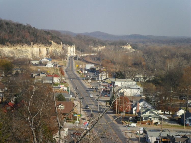
Pacific missouri from the air
Pacific is a city in Franklin and St. Louis counties in the U.S. state of Missouri. The population was 7,002 at the 2010 census.
Contents
- Pacific missouri from the air
- Map of Pacific MO 63069 USA
- History
- Geography
- Commercial areas
- 2010 census
- 2000 census
- Schools and colleges
- Local newspapers
- City parks and attractions
- In popular culture
- References
Map of Pacific, MO 63069, USA
History
Pacific was platted in 1852 when the railroad was extended to that point. It was so named because here the new railroad started for the Pacific Ocean. A post office called Pacific has been in operation since 1854.
The Gustav Grauer Farm was listed on the National Register of Historic Places in 1984.
Geography
Pacific is located at 38°28′53″N 90°45′0″W (38.481503, -90.750015). The city straddles the Franklin County/St. Louis County line, which lies halfway on the blocks between Elm and Neosho streets. St. Louis is 30 miles (50 km) northeast of Pacific, and the communities comprising the Missouri Rhineland are 20 miles (30 km) northwest of the city.
Pacific is bordered on the southeast by the Pacific Palisades Conservation Area. Access to the Meramec River, through the Pacific Palisades Conservation Area, is located east of the city next to Eureka on the north side. The majority of the Pacific Palisades Conservation Area is south of the river and can be accessed 1 mile (1.6 km) south of the city in Jefferson County.
The Union Pacific (formerly Missouri Pacific) railroad, BNSF Railway (formerly St. Louis San-Francisco) Railroad, historic Route 66, Brush Creek, and Fox Creek run through the town.
According to the United States Census Bureau, the city has a total area of 5.93 square miles (15.36 km2), of which, 5.92 square miles (15.33 km2) is land and 0.01 square miles (0.03 km2) is water. 1.7 sq mi (4.4 km2) of the city is located in St. Louis County. The city is located directly west from Eureka and 5 miles (8 km) east of Gray Summit.
Commercial areas
The Old Downtown Commerce Area is mostly located along First and St. Louis streets. The historic downtown buildings, built in the late 1800s, have been fully or partially restored, and new businesses have moved into the buildings.
The Red Cedar Inn, on the east end of town, was a meeting place for people around the country seeking out one of the oldest restaurants still standing on Route 66. The restaurant closed in 2007.
2010 census
As of the census of 2010, there were 7,002 people, 2,368 households, and 1,524 families residing in the city. The population density was 1,182.8 inhabitants per square mile (456.7/km2). There were 2,645 housing units at an average density of 446.8 per square mile (172.5/km2). The racial makeup of the city was 88.4% White, 8.4% African American, 0.6% Native American, 0.5% Asian, 0.6% from other races, and 1.5% from two or more races. Hispanic or Latino of any race were 1.9% of the population. The population total also includes the Missouri Eastern Correctional Facility which houses over 1,000 inmates.
There were 2,368 households of which 32.4% had children under the age of 18 living with them, 44.4% were married couples living together, 14.9% had a female householder with no husband present, 5.1% had a male householder with no wife present, and 35.6% were non-families. 29.1% of all households were made up of individuals and 10.1% had someone living alone who was 65 years of age or older. The average household size was 2.45 and the average family size was 3.00.
The median age in the city was 35.9 years. 20% of residents were under the age of 18; 11.2% were between the ages of 18 and 24; 32.6% were from 25 to 44; 24.6% were from 45 to 64; and 11.5% were 65 years of age or older. The gender makeup of the city was 55.6% male and 44.4% female.
2000 census
As of the census of 2000, there were 5,482 people, 2,166 households, and 1,431 families residing in the city. The population density was 1,011.0 people per square mile (390.5/km²). There are 2,343 housing units at an average Value at $97,987.22 /km² (432.1/sq mi). The racial makeup of the city was 94.35% White, 2.92% African American, 0.38% Asian, 0.31% Native American, 0.04% Pacific Islander, 0.53% from other races, and 1.48% from two or more races. Hispanic or Latino of any race were 1.08% of the population.
There were 2,166 households out of which 33.4% had children under the age of 18 living with them, 46.1% were married couples living together, 15.1% had a female householder with no husband present, and 33.9% were non-families. 28.5% of all households were made up of individuals and 9.7% had someone living alone who was 65 years of age or older. The average household size was 2.48 and the average family size was 3.05.
In the city, the population was spread out with 26.6% under the age of 18, 9.4% from 18 to 24, 31.9% from 25 to 44, 19.7% from 45 to 64, and 12.5% who were 65 years of age or older. The median age was 34 years. For every 100 females there were 94.6 males. For every 100 females age 18 and over, there were 88.4 males.
The median income for a household in the city was $39,554, and the median income for a family was $44,545. Males had a median income of $32,813 versus $22,529 for females. The per capita income for the city was $17,865. About 8.8% of families and 14.7% of the population were below the poverty line, including 19.7% of those under age 18 and 19.4% of those age 65 or over.
Schools and colleges
Pacific and its surrounding communities are served by the Meramec Valley R-III school system and the St. Louis Community College district, and many residents attend nearby East Central College.
Elementary and secondary schools in the Meramec Valley R-III School District:
Local newspapers
City parks and attractions
In popular culture
Pacific is mentioned in the 1980 dark fantasy novel The Land of Laughs by Jonathan Carroll. Considered a cult favorite, the novel is set in the environs of Pacific, in the fictional town of Galen.