
Existed: 1932 – present Constructed 1932 | West end: BC 1 near Hope Length 1,163 km | |
 | ||
Majorjunctions: BC 5 near Hope BC 5A in Princeton BC 97 in Osoyoos BC 22 in Castlegar BC 6 at Salmo BC 95 at Yahk and Cranbrook BC 93 at Cranbrook and Elko Majorjunctions: Hwy 22 near Lundbreck Hwy 6 near Pincher Creek Hwy 2 in Fort Macleod Hwy 23 near Monarch Hwy 5 in Lethbridge Hwy 4 in Lethbridge Hwy 36 in Taber Towns | ||
Driving on hwy 3 crowsnest highway southern british columbia canada canadian countryside
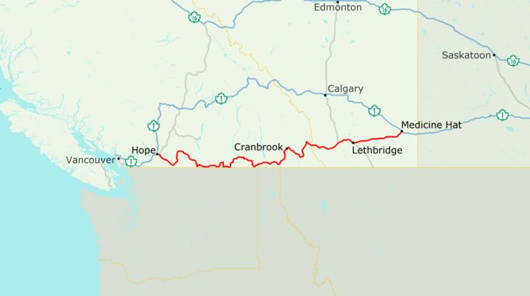
The Crowsnest Highway is an east-west highway in British Columbia and Alberta, Canada. It stretches 1,161 km (721 mi) across the southern portions of both provinces, from Hope, British Columbia to Medicine Hat, Alberta, providing the shortest highway connection between the Lower Mainland and southeast Alberta through the Canadian Rockies. The mostly two-lane highway was officially designated in 1932, mainly following a mid-19th century gold rush trail originally traced out by an engineer named Edgar Dewdney. It takes its name from the Crowsnest Pass, the location at which the highway crosses the Continental Divide between British Columbia and Alberta.
Contents
- Driving on hwy 3 crowsnest highway southern british columbia canada canadian countryside
- Map of Crowsnest Hwy Canada
- British columbia crowsnest highway fernie cranbrook time lapse drive
- Route description
- British Columbia
- Alberta
- Future
- References
Map of Crowsnest Hwy, Canada
In British Columbia, the highway is entirely in mountainous regions and is also known as the Southern Trans-Provincial Highway. The first segment between the Trans-Canada Highway and Highway 5A is locally known as the Hope-Princeton Highway, and passes by the site of the Hope Slide. In Alberta, terrain is initially mountainous, before smoothing to foothills and eventually generally flat prairie in the vicinity of Pincher Creek. The highway forms part of the Red Coat Trail and the CANAMEX Corridor from Highway 2 near Fort Macleod to Highway 4 in Lethbridge.
British columbia crowsnest highway fernie cranbrook time lapse drive
Route description
Crowsnest Highway is designated a core route in Canada's National Highway System, and is designated as Highway 3 for its entire length.
British Columbia
The Crowsnest Highway's total length in British Columbia is 838 km (521 mi), and its total length within Alberta is 323 km (201 mi). The Crowsnest Highway's western terminus is at Hope, where it branches off from Highway 1. The highway goes east for 7 km (4.3 mi) to its junction with Highway 5, then through Allison Pass and Manning Provincial Park for 127 km (79 mi) towards the Town of Princeton. There are several significant ascents in this stretch between Hope and Princeton. The first is the steep climb to the Hope Slide, followed later by the remainder of the climb up to Allison Pass at an elevation of 1,342 m (4,403 ft). After the summit of Allison Pass, where the Crowsnest crosses from the Fraser Valley Regional District into the Regional District of Okanagan-Similkameen, the road descends for 40 km (25 mi) before beginning another long climb up Sunday Summit (1,284 m (4,213 ft)). Soon after Sunday Summit is the descent into Princeton, where Highway 5A begins.
After Princeton, the Crowsnest goes southeast for 67 km (42 mi), through Hedley, to the Village of Keremeos, where a junction with a length of highway designated as 3A is located, leading towards Penticton and Highway 97. Another 46 km (29 mi) southeast, and the Crowsnest reaches the Town of Osoyoos and a junction with Highway 97. The highway then proceeds to hug the Canada–US border east through a stretch of switchbacks known as Anarchist Mountain, which is also the name of the upland rural community beyond the summit. A few kilometres east of Anarchist Mountain, the Crowsnest enters the Regional District of Kootenay Boundary.
52 km (32 mi) east of Osoyoos, the Crowsnest reaches its junction with Highway 33 at Rock Creek, then the highway heads east for 70 km (43 mi) to its junction with Highway 41 at a location called Carson, just west of Grand Forks. Another 26 km (16 mi) east, passing through Grand Forks en route, the Crowsnest meets Highway 395 at the southern end of Christina Lake.
Further east from Christina Lake, the Crowsnest travels for 47 km (29 mi) through Bonanza Pass to its junction with Highway 3B at Nancy Greene Lake, which is the cutoff to the town of Rossland and Red Mountain Resort, shortly thereafter crossing into the Regional District of Central Kootenay. It is another 26 km (16 mi) east from Nancy Greene Lake to the junction with Highway 22 at Castlegar, and another 2 km (1.2 mi) east to a junction with another stretch of Highway designated as 3A, also within Castlegar. Leaving Castlegar, the Crowsnest reaches its eastern junction with Highway 3B 26 km (16 mi) east. Highway 6 converges with the Crowsnest at Salmo, 11 km (6.8 mi) east of the 3B junction, and the two highways proceed south for 14 km (8.7 mi) to the Burnt Flat Junction, where Highway 6 diverges south.
East of Burnt Flat, the Crowsnest heads through the Kootenay Pass on a stretch known as the Kootenay Skyway, or Salmo-Creston Skyway. 67 km (42 mi) east of Burnt Flat, the Crowsnest reaches the Town of Creston, just past junctions with Highway 21 and Highway 3A. 40 km (25 mi) later, south of Yahk, Highway 95 merges onto the Crowsnest. The two highways share a common alignment for 72 km (45 mi) northeast along the Moyie River, crossing into the Regional District of East Kootenay along the way, to a junction with Highway 95A at Cranbrook. Another 6 km (3.7 mi) east, Highway 95 diverges north from the Crowsnest and Highway 93 merges onto the Crowsnest from the north. Highway 93 and the Crowsnest share a common alignment for the next 53 km (33 mi) southeast to Elko, where Highway 93 diverges south. 31 km (19 mi) north of Elko, the Crowsnest reaches Fernie, then it goes north another 30 km (19 mi) to its junction with Highway 43 at Sparwood, and another 19 km (12 mi) east, the highway reaches the boundary with Alberta at Crowsnest Pass.
Alberta
The Alberta portion of the Crowsnest Highway is also designated as Highway 3, running for approximately 323 km (201 mi) from the British Columbia border to Medicine Hat. It begins in Crowsnest Pass paralleling the Canadian Pacific Railway, first meeting Highway 40 at Coleman, then running 26 km (16 mi) east to the southern terminus of Highway 22. Highway 6 splits south near Pincher Creek. Approximately 50 km (31 mi) east of Pincher Creek, the highway becomes divided and interchanges with Highway 2 with which it is briefly concurrent, assuming the designation of the Red Coat Trail and CANAMEX Corridor. It proceeds for 5 km (3 mi) into the town of Fort Macleod, after which Highway 2 splits south to Cardston and the United States border. Highway 3 then crosses the Oldman River east of Fort Macleod near Monarch, prior to a partial interchange with Highway 23.
After Coalhurst, the highway reaches Westview Drive W, which provides access to West Lethbridge. It then becomes a freeway named Crowsnest Trail as it reaches Highway 25 which branches north to Picture Butte while University Drive runs south to the University of Lethbridge as the main thoroughfare through West Lethbridge. Highway 3 again crosses the Oldman River in central Lethbridge and the freeway segment ends at Mayor Magrath Drive, marking the northern terminus of Highway 5. The highway meets the northern end of Highway 4 at the eastern limit of Lethbridge before continuing east to Coaldale and Taber. Within Taber, Highway 36 runs concurrently with Highway 3 for 3 km (2 mi). The highway reduces to a two-lane undivided road and the Crowsnest Highway ends 113 km (70 mi) later at the Trans-Canada Highway in Medicine Hat.
Future
Alberta Transportation has long-term plans to upgrade the entire Highway 3 corridor to a freeway from the British Columbia border to Medicine Hat. The plans include the construction of a Lethbridge bypass to render the CANAMEX Corridor free-flowing through southern Alberta, in combination with proposed bypasses of Fort Macleod, Claresholm and Nanton. The route would split from Highway 3 west of Coalhurst and run east, bypassing Lethbridge and Coaldale to the north before rejoining the existing highway.
British Columbia
The following is a list of major intersections along British Columbia Highway 3 (Crowsnest Highway).
Alberta
The following is a list of major intersections along Highway 3 in Alberta from west to east.