
Country Canada Postal code prefixes V Area 36,303 km² Province British Columbia | Time zone PST (UTC−8) Area code(s) 236, 604, 778 Population 2.832 million (2016) | |
 | ||
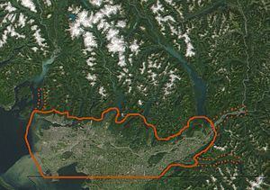
Winter at lower mainland burnaby surrey and new westminster bc ca
The Lower Mainland is a name commonly applied to the region surrounding and including Vancouver, British Columbia, Canada. As of 2016, 2,832,000 people (60% of British Columbia's total population), lived in the region; sixteen of the province's thirty most populous municipalities are located there. Islands contained within rivers in the region are considered to be part of the Lower Mainland.
Contents
- Winter at lower mainland burnaby surrey and new westminster bc ca
- 2016 lower mainland finals moscrop vs van tech
- Geography
- Population
- Regional districts
- Aboriginal territories
- Health Regions
- Flooding
- Earthquakes
- Communities
- References
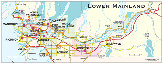
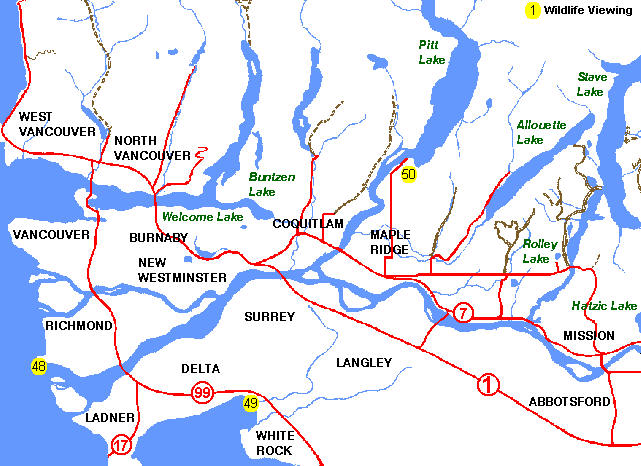
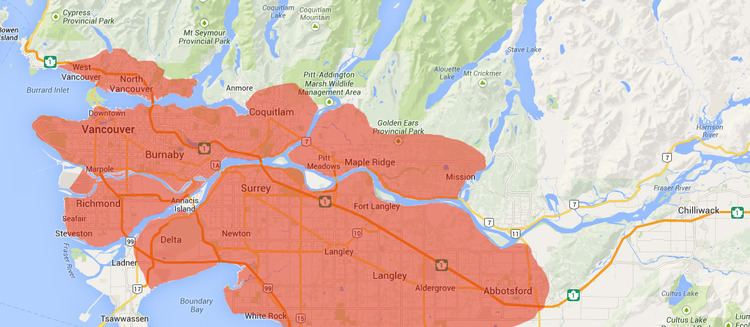
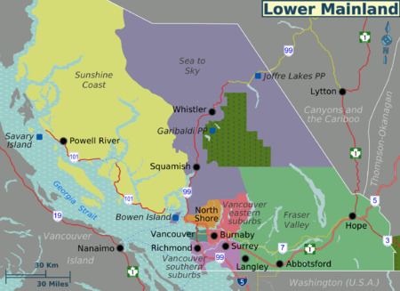
While the term Lower Mainland has been recorded from the earliest period of non-native settlement in British Columbia, it has never been officially defined in legal terms. The British Columbia Geographical Names Information System (BCGNIS) comments that most residents of Vancouver might consider it to be only areas west of Mission and Abbotsford, while residents in the rest of the province consider it to be the whole region south of Whistler and west of Hope. However, the term has historically been in popular usage for over a century to describe a region that extends from Horseshoe Bay south to the Canada–United States border and east to Hope at the eastern end of the Fraser Valley.
Climate, ecology and geology of the Lower Mainland are consistent enough that it has been classified as a separate ecoregion (the Lower Mainland Ecoregion) within the Ecological framework of Canada, used by both Federal and Provincial Environment Ministries. The region is the traditional territory of the Sto:lo, a Halkomelem-speaking people of the Coast Salish linguistic and cultural grouping. There are two Regional Districts within the region, Metro Vancouver and the Fraser Valley Regional District.
2016 lower mainland finals moscrop vs van tech
Geography
The region is bounded to the north by the Coast Mountains and to the southeast by the Cascade Mountains, and is traversed from east to west by the Fraser River. Due to its consistency of climate, flora and fauna, geology and land use, "Lower Mainland" is also the name of an ecoregion—a biogeoclimatic region—that comprises the eastern part of the Georgia Depression and extends from Powell River on the Sunshine Coast to Hope at the eastern end of the Fraser Valley.
One of the mildest climates in Canada, the region has a mean annual temperature of 9 °C with a summer mean of 15 °C and a winter mean of 3.5 °C. Annual precipitation ranges from an annual mean of 850 mm in the west end to 2000 mm in the eastern end of the Fraser Valley and at higher elevations. Maximum precipitation occurs as rain in winter. Less than ten percent falls as snow at sea level but the amount of snowfall increases significantly with elevation.
Population
In 2011 there were 2,590,921 people living in the communities of the Lower Mainland:
These figures are slightly inflated due to the inclusion of areas within the Regional Districts which are not normally considered to be part of the Lower Mainland, notably the lower Fraser Canyon and the heads of Harrison and Pitt Lakes, which are within the FVRD, and Lions Bay and Bowen Island, which are within the Greater Vancouver Regional District.
The population of the Lower Mainland was up 9.2 percent from the 2006 census. This is among the highest growth rates in the continent.
As of Statistics Canada estimates in 2015, the population of the Lower Mainland totals approximately 2,825,232:
Regional districts
Regional districts were first created across British Columbia in 1966–1967 to form bodies for inter-municipal coordination and to extend municipal-level powers to areas outside existing municipalities. Today, the Lower Mainland includes two Regional Districts: the Greater Vancouver Regional District and the Fraser Valley Regional District (FVRD). Both regional districts, however, include areas outside the traditional limits of the Lower Mainland, and the Fraser Valley as a term includes much of the GVRD.
The Greater Vancouver Regional District (GVRD) is made up of 21 municipalities. The GVRD is bordered on the west by the Strait of Georgia, to the north by the Squamish-Lillooet Regional District, on the east by the Fraser Valley Regional District, and to the south by Whatcom County, Washington, in the United States.
The Fraser Valley Regional District lies east of the Greater Vancouver Regional District, and comprises the cities of Abbotsford and Chilliwack, the district municipalities of Mission, Kent, and Hope, and the village of Harrison Hot Springs. It also includes many unincorporated areas in the Fraser Valley and along the west side of the Fraser Canyon (the Fraser Canyon is not in the Lower Mainland).
Regional district powers are very limited and other localized provincial government services are delivered through other regionalization systems.
Aboriginal territories
The traditional territories of the Musqueam and Tsleil'waututh lie completely within the region; the southern portion of Squamish traditional territory is also in the region. Its claims overlap those of the Tsleil-waututh, Musqueam, and Kwikwetlem. Other peoples whose territories lie within the region are the Sto:lo, Chehalis, Katzie, Kwantlen, Tsawwassen, and Semiahmoo; many of their territories overlap with those of the Musqueam, and with each other. Many other peoples of the Georgia Strait region also frequented the lower Fraser, including those from Vancouver Island and what is now Whatcom County, Washington.
Sto:lo traditional territory, known as Solh Temexw in Halkomelem, more or less coincides with the traditional conception of the Lower Mainland, except for the inclusion of Port Douglas at the head of Harrison Lake, which is in In-SHUCK-ch territory, and the lands around Burrard Inlet.
Health Regions
Health system services and governance in the Lower Mainland are provided by Vancouver Coastal Health, serving Vancouver, Richmond and the North Shore, and the mainland coast as far north as the Central Coast region, and Fraser Health, which serves the area of the Lower Mainland east of Vancouver and Richmond.
Flooding
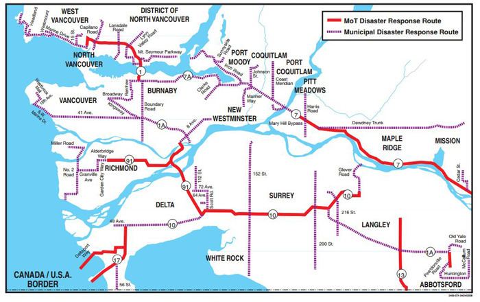
The Lower Mainland is considered to have a high vulnerability to flood risk. There have been two major floods, the largest in 1894 and the second largest in 1948. According to the Fraser Basin Council, scientists predict a one-in-three chance of a similar-sized flood occurring in the next 50 years.
In the spring of 2007, the Lower Mainland was on high alert for flooding. Higher than normal snow packs in the British Columbia Interior prompted municipal governments to start taking emergency measures in the region. Dikes along the Fraser River are regulated to handle about 8.5 m at the Mission Gauge (the height above sea level of the dykes at Mission). Warmer than normal weather in the interior caused large amounts of snow to melt prematurely, resulting in higher than normal water levels, which, nevertheless, remained well below flood levels.
Flooding can cover much of the Lower Mainland. Cloverdale, Barnston Island, low-lying areas of Maple Ridge, areas west of Hope, White Rock, Richmond, parts of Vancouver, and parts of Surrey are potentially at risk. In 2007, the Lower Mainland was largely spared, although northern regions of the province, along the Skeena and Nechako Rivers, experienced floods. Climate scientists predict that increasing temperatures will mean wetter winters and more snow at the high elevations. This will increase the likelihood of snowmelt floods.
The provincial government maintains an integrated flood hazard management program and extensive flood protection infrastructure in the Lower Mainland. The infrastructure consists of dikes, pump stations, floodboxes, riprap, and relief wells.
Earthquakes
While earthquakes are common in British Columbia and adjacent coastal waters, most are minor in energy release or are sufficiently remote to have little effect on populated areas. Nevertheless, earthquakes with a magnitude of up to 7.3 have occurred within 150 kilometres of the Lower Mainland.
Based on geological evidence, however, stronger earthquakes appear to have occurred at approximately 600-year intervals. Therefore, there is a probability that there will be a major earthquake in the region within the next 200 years.
In April 2008, the United States Geological Survey released information concerning a newly found fault line south of downtown Abbotsford, called the Boulder Creek Fault. Scientists now believe this fault line is active and capable of producing earthquakes in the 6.8 magnitude range.
Communities
The Lower Mainland's communities includes large cities in Metro Vancouver, and smaller cities, towns and villages along both banks of the Fraser River. Neighbourhoods within cities are not listed unless historically or otherwise notable and/or separate. Only some of the many Indian Reserves are listed.