
Incorporated 1946 Elevation 450 m Population 7,816 (2011) | Time zone PST (UTC-8) Local time Monday 2:51 AM | |
 | ||
Weather -1°C, Wind S at 5 km/h, 80% Humidity | ||
Castlegar is the second largest city in the West Kootenay region of British Columbia, Canada.
Contents
- Map of Castlegar BC Canada
- History
- Native history
- Doukhobor history
- Demographics
- Climate
- Airport
- Schools
- Recreation
- Sports
- Geography
- Transportation
- Notable residents
- Sister cities
- References
Map of Castlegar, BC, Canada
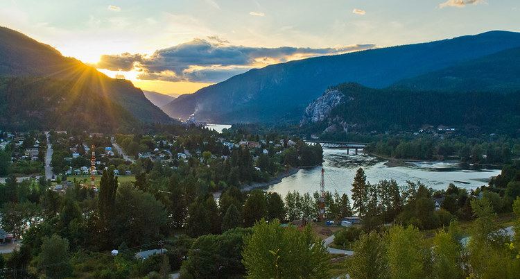
It is located within the Selkirk Mountains at the confluence of the Kootenay and Columbia Rivers. It is a regional trade and transportation centre, with a local economy fueled by forestry, mining and tourism. It was recently cited as one of the Top 8 Places in British Columbia for most promising growth. It is home to Selkirk College, a regional airport, a pulp mill, and several sawmills. The population of 7,259 people includes a large number of Doukhobors, who were largely responsible for much of Castlegar's early development and growth. A sizeable Portuguese community grew as workers, mainly from the Azores islands, moved in to take up employment in the area. The area which was to become Castlegar was an important centre for the Sinixt (Lakes) Peoples. Outside the city limits are the small surrounding communities of Ootischenia, Brilliant, Robson, Robson West, Raspberry, Tarrys, Thrums, Glade, Shoreacres, Fairview, Genelle, Pass Creek and Krestova. There are also the much smaller communities of Deer Park, Renata, and Syringa on Lower Arrow Lake. Taken together, these outlying areas comprise an approximate population of a further 8,000 people.
History
On September 5, 1811, David Thompson arrived at the location where Castlegar now sits, where he camped near the mouth of the Kootenay River. A plaque dedicated to David Thompson can be found on the east bank of the Columbia River overlooking the present day site of Castlegar.
The first settlement in the area was West Waterloo, now known as South Castlegar. There was widespread provincial interest in gold prospecting in the late 19th century, and by 1895 there were forty houses in Waterloo. The town boomed until the end of the century when interest in the local mines declined.
Castlegar takes its name from Castlegar, County Galway in Ireland, the ancestral home of townsite founder Edward Mahon. (Castlegar is on the eastern boundary of the city of Galway.) The city was planned in 1897. Around 1902, the Canadian Pacific Railway (CPR) built the bridge at Castlegar and laid the wide gauge railway tracks to Trail. They put in a box car station at the old Waterloo trail crossing and called it Kinnaird Station in honour of Lord Kinnaird who was a shareholder in the CPR.
There was little in Castlegar until after the completion of the CPR bridge. A Mr. Farmer built the first store in town, housing both the post office and the town hall. William Gage built the Castlegar Hotel in 1908, standing until 1982 when it was destroyed by fire. Also in 1908, the first schoolhouse was built by a few local residents who bought the lumber and erected the building. A dance pavilion, garage, tourist cabins and a slaughterhouse had all been established by 1925.
On October 30, 1946, Castlegar was incorporated into a village, then in 1966 into a town. It amalgamated with the neighbouring town of Kinnaird into a city on January 1, 1974, effectively doubling the population. On May 20, 2004, the City's boundary was extended to include the Blueberry Creek Irrigation District.
Native history
Castlegar is located in the border area between the Sinixt (Interior Salish) and the Ktunaxa Indian bands. Experts cannot agree where the Ktunaxa range ended, and where the Sinixt began. There was much overlapping of cultural and territorial activity between the two peoples. Most recent information suggests that the Sinixt were the original people in the area, and that the Kootenai arrived several hundred years ago from central Canada.
"Qepitles" was a site on the north side of the Kootenay River, just above the junction with the Columbia River. Native implements (arrowheads, pestles, etc.) have been found along the nearby Arrow Lakes. A reconstructed kekuli dwelling was formally located on Zuckerberg Island, at the confluence of the Kootenay and Columbia rivers.
Doukhobor history
The Doukhobors put a ferry into operation near Brilliant on the Kootenay River in 1910 and the Christian Community of Universal Brotherhood (CCUB) made an application to the CPR for a railway station and siding to this point. Brilliant was the centre of the CCUB commercial enterprises. Located on the site was the Brilliant Jam Factory, a grain elevator, and a flax seed mill.
Demographics
Climate
Castlegar has either a mediterranean climate (Köppen or a Csb) humid continental climate (Köppen Dfb) depending on isotherm used. This renders hot days and cool nights in summer, with moderately dry weather and cold winters with heavy snowfall due to the mediterranean tendencies of high winter precipitation. Castlegar is wetter than most places in the Southern Interior of BC, as the city receives around 400 mm more precipitation than nearby Kelowna, Penticton and Kamloops (which are in the dryer Okanagan region of British Columbia, while Castlegar is in the Kootenay region).
The highest temperature ever recorded in Castlegar was 41.1 °C (106 °F) on 2 July 1924 and 11 July 1926. The coldest temperature ever recorded was −30.6 °C (−23 °F) on 30 December 1968.
Airport
The West Kootenay Regional Airport is owned and operated by the City of Castlegar. The Airport has regular service to both Vancouver International Airport and Calgary International Airport. Nearby airports include Trail Airport, which is 40 km to the south.
Schools
Castlegar is part of School District 20 Kootenay-Columbia and schools in the town include:
Four elementary schools:
One high school:
Selkirk College's main campus is also located in Castlegar.
Recreation
Many great walking trails are located in and near Castlegar. They are maintained by the Castlegar Friends of Parks and Trails Society. The area attracts retirees and tourists for its summer and winter sports.
The Columbia River cuts through Castlegar, and to the west along the river are Scotties Marina and Syringa Provincial Park, with boating and camping amenities.
Sports
The city's Collegiate hockey team is the Selkirk College Saints of the BCIHL, who, as of 2016, are 4 time defending league champions. The Castlegar Rebels of the KIJHL are the city's Junior "B" level hockey team. Other activities include The Castlegar Skating Club, Dancing at Turning Pointe Dance Studio and Scottie School of Highland Dance, Castlegar Aquanauts, Castlegar Minor Soccer Association, Selkirk Challengers Gymnastics Club, Castlegar Minor Hockey, Baseball, Lacrosse, Golf, Curling, Tennis, Volleyball, Basketball programs, Kootenay Jiu Jitsu Academy, and Many yoga/fitness etc. programs are offered at the Castlegar Community Complex. West Kootenay Minor Football Association, Castlegar Sentinels Football Club.
Geography
The main street, Columbia Avenue, runs the length of the City of Castlegar. It becomes Highway 22 on the South end, and the Robson Bridge at the North end. Most businesses in Castlegar are located on or just off of Columbia. There are several neighbourhoods in Castlegar, including Downtown, Southridge, Oglow Subdivision, Woodland Park, Grosvenor, Kinnaird, and Blueberry Creek, among others. Outskirts of Castlegar include Robson, Robson West, Brilliant, Raspberry, Pass Creek, Ootischenia, Tarrys, Thrums, and Genelle.
Transportation
The City of Castlegar is considered to be a transportation hub for the region. It is the location of the West Kootenay Regional Airport (YCG), the main local airport in the region with flights to both Vancouver and Calgary. It is also the junction of highways 3B, 3, and 22. Highway 22 runs the length of the city, known as Columbia Avenue. At the North End, Columbia enters the Robson Bridge, carrying traffic to the rural suburb of Robson, which is accessed via Broadwater Road. A small highway interchange exists where the Robson Access Road meets Highway 3B towards Nelson, British Columbia. Highway 3 bisects the town, providing the main access to the Grovesnor area, and crossing the Columbia River at the Kinnaird Bridge, to Ootischenia. Highway 3B and Highway 3 both provide routes through Ootischenia. Highway 22 also connects to Blueberry. To the North, Highway 3B heads to Nelson. To the South, Highway 22 leads to Trail, British Columbia; to the East, Highway 3 Leads to Salmo, British Columbia, and to the West to Grand Forks, British Columbia.