
Country Canada Census division 1 Elevation 690 m (2,260 ft) Local time Friday 7:10 AM | Region Southern Alberta Founded 1883 Demonym(s) Hatter Population 63,260 (2016) University Medicine Hat College | |
 | ||
Weather 1°C, Wind SW at 10 km/h, 95% Humidity | ||
Experience culture in medicine hat alberta canada
Medicine Hat is a city in southeast Alberta, Canada. It is approximately 169 km (105 mi) east of Lethbridge and 295 km (183 mi) southeast of Calgary. This city and the adjacent Town of Redcliff to the northwest are surrounded by Cypress County. Medicine Hat was the sixth-largest city in Alberta in 2016 with a population of 63,230.
Contents
- Experience culture in medicine hat alberta canada
- Map of Medicine Hat AB Canada
- Exploring downtown medicine hat ab time lapse
- Name origins
- Founding
- Progress and growth
- Geography
- Climate
- Neighbourhoods
- Housing
- Demographics
- Attractions
- Parks
- Sports
- Government
- Infrastructure
- Education
- Media
- Law Enforcement
- Military
- Notable people
- References
Map of Medicine Hat, AB, Canada
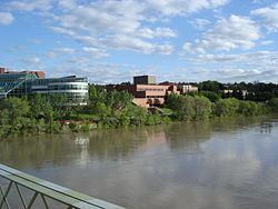
Medicine Hat is situated on the Trans-Canada Highway (Highway 1), the eastern terminus of the Crowsnest Highway (Highway 3), and the South Saskatchewan River. Nearby communities considered part of the Medicine Hat area include the Town of Redcliff (abutting the city's northwest boundary) and the hamlets of Desert Blume, Dunmore, Irvine, Seven Persons, and Veinerville. The Cypress Hills (including Cypress Hills Interprovincial Park) is a relatively short distance (by car) to the southeast of the city.
Historically, Medicine Hat has been known for its large natural gas fields, being immortalized by Rudyard Kipling as having "all hell for a basement". Because of these reserves, the city is known as "The Gas City".
Exploring downtown medicine hat ab time lapse
Name origins
The name "Medicine Hat" is the English translation of Saamis (SA-MUS) – the Blackfoot word for the eagle tail feather headdress worn by medicine men – or "Medicine Hat". Several legends are associated with the name from a mythical mer-man river serpent named Soy-yee-daa-bee – the Creator – who appeared to a hunter and instructed him to sacrifice his wife to get mystical powers which were manifest in a special hat. Another legend tells of a battle long ago between the Blackfoot and the Cree in which a retreating Cree "Medicine Man" lost his headdress in the South Saskatchewan River.
A number of factors have always made Medicine Hat a natural gathering place. Before Europeans arrived, the Blackfoot, Cree and Assiniboine nations used the area for hundreds of years. The gently sloping valley with its converging waterways and hardy native cottonwood trees attracted both humans and the migratory bison herds which passed through the area.
Founding
In 1883, when the Canadian Pacific Railway (CPR) reached Medicine Hat and crossed the river a town site was established using the name from the First Nations legends. As the west developed, Medicine Hat became instrumental with the development of the first hospital past Winnipeg in 1889 and as a CPR divisional point. It was incorporated as a town on October 31, 1898, and as a city on May 9, 1906. Medicine Hat is halfway between Winnipeg and Vancouver.
Progress and growth
Rich in natural resources including natural gas, coal, clay, and farmland, the town was known in the early days as "the Pittsburgh of the West". A number of large industries located here, under the inducement of cheap and plentiful energy resources. Coal mines, brick works, pottery and glass bottle manufacturing plants, flour mills, etc. became established. The agricultural potential of the surrounding area, both in crop and livestock, also made the town a viable service centre with a well established transportation route. An economic boom was experienced between 1909–1914 bringing the population to over 10,000. Little growth occurred between the World Wars, although the population swelled in the mid-1940s due to the town hosting one of the largest Second World War P.O.W. camps in Canada. It was not until the 1950s that the town again experienced significant commercial development. Today, Medicine Hat prides itself as one of the most economical places to live in Canada, with its unique city-owned gas utility and power generation plant being predominant factors. Major industries have included chemical plants, a Goodyear tire and rubber plant, greenhouses, numerous oil and gas related companies, a foundry, I-XL Industries (a brickworks dating from the 1880s), to name a few.
Geography
The Medicine Hat landscape is dominated by the South Saskatchewan River valley. In addition to this major river, both the Seven Persons Creek and Ross Creek empty into the South Saskatchewan River within the City of Medicine Hat boundary. The presence of these water bodies provide for a dramatic valley landscape with numerous cliffs, and finger coulees throughout the city. Beyond the city and river valley the land is flat to slightly rolling and is characterized by short-grass vegetation. Medicine Hat is also known as Canada's sunniest city.
Forty kilometres (about twenty-five miles) to the east at 50°0′38.2″N 110°6′48.3″W lies the Badlands Guardian Geological Feature. It is a landscape formation taking the form of a head wearing a feathered headdress. The head is 1,000 feet (300 m) wide. It is in inverse relief, formed by valleys rather than raised ground.
Climate
Located in the steppe region known as Palliser's Triangle, Medicine Hat has a semi-arid, continental climate (Köppen climate classification BSk), with cold winters, and warm to hot, dry summers. Frequently, the winter cold is ameliorated by mild and dry chinook winds blowing from the west, and hot summer daytime temperatures are made more tolerable by low humidity and rapid cooling in the evening hours. Medicine Hat receives less precipitation annually than most other cities on the Canadian Prairies and plentiful sunshine (widely known as "The sunniest city in Canada"), making it a popular retirement city. Maximum precipitation typically occurs in the late spring and early summer.
The highest temperature ever recorded in Medicine Hat was 42.2 °C (108 °F) on 12 July 1886. The coldest temperature ever recorded was −46.1 °C (−51 °F) on 4 February 1887.
Neighbourhoods
Housing
The average home price in Medicine Hat as of the end of September 2012 was $258,535.
Demographics
In the 2016 Census of Population conducted by Statistics Canada, the City of Medicine Hat recorded a population of 63,260 living in 26,652 of its 27,970 total private dwellings, a change of 7000540000000000000♠5.4% from its 2011 population of 60,005. With a land area of 112.04 km2 (43.26 sq mi), it had a population density of 564.6/km2 (1,462.4/sq mi) in 2016.
The population of the City of Medicine Hat according to its 2015 municipal census is 63,018, a change of 7000300000000000000♠3% from its 2012 municipal census population of 61,180,
In the 2011 Census, the City of Medicine Hat had a population of 60,005 living in 25,445 of its 27,342 total dwellings, a change of 5.3% from its 2006 population of 56,997. With a land area of 112.01 km2 (43.25 sq mi), it had a population density of 535.7/km2 (1,387.5/sq mi) in 2011. Also in 2011, the Medicine Hat population centre had a population of 65,671, while the Medicine Hat census agglomeration had a population of 72,807. The population centre includes the adjacent Town of Redcliff to the northwest and a small portion of Cypress County to the east that includes the Hamlet of Veinerville, while the census agglomeration includes Redcliff and Cypress County in its entirety.
More than 89 percent of residents identified English as their first language at the time of the 2006 census, while 6 percent identified German and just over 1 percent each identified Spanish and French as their first language learned. The next most common languages were Ukrainian, Chinese, Dutch, and Polish.
More than 79 percent of residents identified as Christian at the time of the 2001 census while almost 20 percent indicated they had no religious affiliation. For specific denominations Statistics Canada counted 16,175 Roman Catholics (26.5 percent), 9,445 members of the United Church of Canada (15.5 percent), and 6,170 Lutherans (slightly more than 10 percent). Less numerous denominations included 3,780 Anglicans (more than 6 percent), 1,745 members of the Evangelical Missionary Church (almost 3 percent), 1,470 Baptists (over 2 percent), 1,220 identifying as Pentecostal (2 percent), 1,220 Latter-day Saints (2 percent), and 675 Presbyterians (just over 1 percent).
Attractions
The Medicine Hat Clay Industries National Historic District is a living, working museum that offers a unique and extensive experience through collections, exhibits, interpretation, guided tours and educational and artistic programming. The Medalta Potteries and Hycroft China Factory Complexes are the focal points in this 150-acre (0.6 km2) region. This nationally recognized industrial historic district is a cultural initiative of the Friends of Medalta Society with Federal, Provincial, Municipal and Private support. Restoration, preservation and cultural development of the Medicine Hat Clay Industries National Historic District for the purpose of education and public enjoyment is ongoing.
Just south of the Trans-Canada Highway and overlooking the Blackfoot buffalo jump is the world's tallest teepee, the "Saamis Teepee". Designed for the 1988 Winter Olympics in Calgary as a symbol of Canada's Aboriginal heritage, it was moved to Medicine Hat in 1991. It stands over 20 stories high and was designed to withstand extreme temperatures and winds up to 240 km/h (150 mph). During a January 2007 windstorm, a portion of the teepee was damaged. Upon further inspection, it was discovered that extensive weathering was partially to blame. After repairs were complete, the Saamis Teepee now stands approximately 15 feet (4.6 m) shorter.
The Medicine Hat Family Leisure Centre is the largest indoor multi-purpose facility in the city. The building is 90,000 sq ft (8,000 m2) and is sited on 57 acres (230,000 m2) in the north end of the city. The facility includes an Olympic-sized ice rink, 50m pool, waterslide, diving platforms, kiddies pool, wave pool and cafe. It is currently undergoing an extensive renovation to include an indoor soccer facility, track and improved fitness centre. The improvements will almost double the size of the facility. In the area surrounding the Leisure Centre facility there are several other sporting venues including; 4 ball diamonds, lighted football field, 3 soccer pitches and one of the largest BMX racing facilities in Southern Alberta.
Located in downtown Medicine Hat, The Esplanade is a large multi purpose cultural centre. The facility features a 700+ seat performing arts theatre, art gallery, museum, archives, gift shop, and cafe. The Esplanade officially opened in October 2005.
The Medicine Hat Drag Racing Association is located just off the Trans Canada Highway on Boundary Road or the spectators entrance on Box Springs Road. This is Alberta's only sanctioned NHRA track and is a 1/4 mile in length. The facility proudly supports affordable family entertainment and encourages people to race the strip, not the street. The seasons typically run from May till September hosting a variety of events from jet and alcohol cars, bracket racing and the NHRA National open which attracts approx. 300+ cars from all over North America.
Medicine Hat Public Library is located across the street from The Esplanade. It has over 10,000 annual members and is the resource library for the Shortgrass Library System of Southern Alberta.
Parks
There are over 100 kilometres (62 mi) of walking trails in the city. All of the major parks are linked by the extensive trail system.
Sports
The city is home to the Medicine Hat Tigers, a major junior ice hockey team in the Western Hockey League (WHL). Established in 1970, the team has won seven division titles, five WHL league championships and back-to-back Canadian Hockey League (CHL) Memorial Cups in 1987 and 1988 in its history. Numerous Tigers alumni moved on to play in the National Hockey League (NHL). Lanny Mc Donald played WHL hockey for the Medicine Hat Tigers. He played in 1971-1972 and scored 50 goals and assisted on 64 goals. In 1972-1973 seasons he scored 62 goals and 77 assists.
The city is also home to the Medicine Hat Mavericks, a summer collegiate baseball team in the Western Major Baseball League (WMBL). Established in 2003, the team plays at Athletic Park stadium in downtown Medicine Hat.
Government
LaVar Payne has served as Member of Parliament for Medicine Hat since October 2008, and was re-elected in 2011. He announced in 2014 that he would not be running in the next election in October 2015. The previous MP was Monte Solberg. Both Payne and Solberg are members of the Conservative Party of Canada. Medicine Hat has two provincial ridings. One is named Medicine Hat, and is represented by the New Democratic Party (NDP), while the other one is named Medicine Hat-Cypress, and is represented by the Wildrose Party.
Infrastructure
Alberta Transportation is currently negotiating with landowners south of the city to secure land for the future Highway 1 (Trans-Canada Highway) bypass. The bypass is expected to be constructed in the next 10–20 years.
The city owns the gas production, gas distribution, electric generation and electric distribution utilities that serve the citizens. The city-owned gas utility is the 30th largest natural gas producer (by volume produced) in Canada.
The city is working on design of the South-West Sector Sanitary Trunk main, extension of South Boundary Road from Strachan Road to Southridge Drive, and a South-West Sector water transmission line. This infrastructure will accommodate the development of new residential communities west of South Ridge Dr, and south of the Seven Persons Creek.
The city is served by the Medicine Hat Airport and Medicine Hat Transit.
Acute medical care is provided to residents at Medicine Hat Regional Hospital.
Beginning in 2009, several ICT business leaders began working together to facilitate economic growth and diversify the local economy by building a robust community network based on fiber optic technologies.
Education
Medicine Hat School District No. 76 has been serving the needs of public school students since it came into existence in 1886. The District has five trustees and comprises three secondary schools, Alexandra Middle School (formerly Alexandra Junior High School), Crescent Heights High School and Medicine Hat High School, 12 elementary (K–6) schools, a special needs school for the severely disabled, as well as an Alternative School program which incorporates a joint partnership with the YMCA Teen Moms' Program, YMCA Stay-in-School Program, a program with the former Palliser Health Region for secondary students and a program supported by Alberta Children Services for students with behavioural needs. French immersion programming is provided as an option. The District currently works with BHTH Instituation for Education to operate an international educational program in China and 3 schools have joined this program, such as Tangshan Caofeidian #2 School, Qinhuangdao Foreign Language School, and Shandong Weifang Middle School.
The Medicine Hat Catholic/Separate School District provides educational programming for students from kindergarten through Grade 12. French immersion programming is provided as an option in select District schools. It operates one high school, Monsignor McCoy, and nine other schools.
Medicine Hat also has a Francophone school, École Les Cyprès, and a public/charter school, the Centre for Academic and Personal Excellence (CAPE).
The Medicine Hat College is located in south Medicine Hat. The first students were accepted to the college in 1965. Now with over 2,500 students and three campuses, the college has grown into an integral part of the community. The Medicine Hat College Rattlers athletic program include basketball, volleyball, golf, soccer and futsol.
Media
Medicine Hat has several radio and television stations broadcasting from it, as well as a few distant AM radio stations from Calgary. Medicine Hat News publishes a daily newspaper.
Law Enforcement
Medicine Hat funds and employs its own municipal police service, the Medicine Hat Police Service. MHPS dates back to 1899.
Military
Medicine Hat is home to the South Alberta Light Horse (SALH), an army reserve unit. The SALH dates back to 1885 when it took part in the North-West Rebellion. Since then it has gained battle honours in the First and Second World Wars and today its members continue to serve overseas on United Nations and North Atlantic Treaty Organization missions. Currently the SALH has members serving in Afghanistan.
Medicine Hat was also home to a British Commonwealth Air Training Plan airfield and a POW camp during the Second World War.
Canadian Forces Base Suffield is located 50 kilometres (31 mi) west of the city. It is estimated that the base contributes C$120 million annually to the local economy, principally through its two lodger units: British Army Training Unit Suffield, and Defence Research and Development Canada – Suffield).