
Country Canada | Elevation 2,616 m | |
 | ||
Type of rock Igneous, Metamorphic and Sedimentary Similar | ||
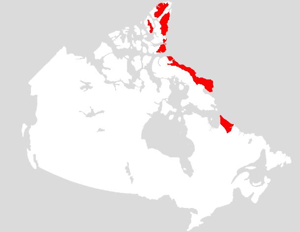
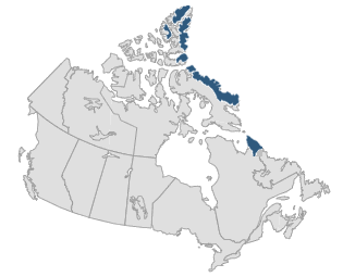
The Arctic Cordillera is a vast, deeply dissected chain of mountain ranges extending along the northeastern flank of the Canadian Arctic Archipelago from Ellesmere Island to the northeasternmost part of the Labrador Peninsula in northern Labrador and northern Quebec, Canada. It spans most of the eastern coast of Nunavut with high glaciated peaks rising through icefields and some of Canada's largest ice caps, including the Penny Ice Cap on Baffin Island. It is bounded to the east by Baffin Bay, Davis Strait and the Labrador Sea while its northern portion is bounded by the Arctic Ocean.
Contents
- Overview
- Regions
- Protected areas
- Glaciers and ice caps
- Geology
- Volcanism
- Mountain ranges
- Axel Heiberg Island
- Baffin Island
- Bathurst Island
- Bylot Island
- Devon Island
- Ellesmere Island
- le Vanier
- Labrador and Quebec
- Flora and fauna
- Climate
- References
Overview

The range is mostly located in Nunavut but extends southeast into the northernmost tip of Labrador and northeastern Quebec. The system is divided into a series of ranges, with mountains reaching heights more than 2,000 m (6,562 ft). The highest of the group is Barbeau Peak on Ellesmere Island at 2,616 m (8,583 ft), which is the highest point in eastern North America. The system is also one of Canada's three mountain systems, the others being the Western Cordillera of Western Canada and the Canadian extension of the Appalachian Mountains into the Gaspé Peninsula and Atlantic Provinces.
The Arctic Cordillera is a narrow ecozone compared to other Canadian ecozones. The majority of this ecozone borders the Northern Arctic, while the small segment within Labrador borders the Taiga Shield. However, bordering the Taiga Shield seems to affect neither itself nor the ecozones it borders because their biological properties appear to be opposites (cold climate versus warm climate; different species of plants and animals). While the Arctic Cordillera mountain system includes most of the Arctic islands and regions such as Bathurst Island, Cornwall Island, Amund Ringnes Island, Ellef Ringnes Island, Ellesmere Island, Baffin Island, Bylot Island and Labrador, the Arctic Cordillera Ecozone only covers Ellesmere Island, Baffin Island, Axel Heiberg Island, Bylot Island and Labrador.
Regions
The Arctic Cordillera contains numerous regions. Much of Ellesmere Island is covered by the Arctic Cordillera, making it the most mountainous in the Canadian Arctic Archipelago. It is considered part of the Queen Elizabeth Islands, with Cape Columbia being the most northerly point of land in Canada. It encompasses an area of 196,235 km2 (75,767 sq mi), making it the world's tenth largest island and Canada's third largest island. The first inhabitants of Ellesmere Island were small bands of Inuit drawn to the area for Peary caribou, muskox, and marine mammal hunting about 1000–2000 BC.
Axel Heiberg Island is one of the several members of the Canadian Arctic Archipelago and the largest of the Sverdrup Islands. It has been inhabited in the past by Inuit people but was uninhabited by the time it was named by Otto Sverdrup, who explored it around 1900. In 1959, scientists from McGill University explored Expedition Fiord in central Axel Heiberg Island. This resulted in the establishment of the McGill Arctic Research Station, constructed 8 km (5 mi) inland from Expedition Fjord in 1960.
Baffin Island is the largest island in Canada and the fifth largest island in the world, with an area of 507,451 km2 (195,928 sq mi).
The largest uninhabited island on Earth, Devon Island is the second-largest of the Queen Elizabeth Islands, the 27th largest island in the world and Canada's 6th largest island. An outpost was established at Dundas Harbour in August 1924 as part of a government presence intended to curb foreign whaling and other activity.
Much of Bylot Island is covered by the Arctic Cordillera. At 11,067 km2 (4,273 sq mi) it is ranked 71st largest island in the world and Canada's 17th largest island. While there are no permanent settlements on this Canadian Arctic island, Inuit from Pond Inlet and elsewhere regularly travel to it.
Protected areas
More than one-fifth of Ellesmere Island is protected as Quttinirpaaq National Park (formerly Ellesmere Island National Park), which includes seven fjords and a variety of glaciers, as well as Lake Hazen, the world's largest lake north of the Arctic Circle. Barbeau Peak, the highest mountain in Nunavut (2,616 m (8,583 ft)) is located in the British Empire Range on Ellesmere Island. The most northern mountain range in the world, the Challenger Mountains, is located in the northwest region of the island. The northern lobe of the island is called Grant Land. In July 2007, a study noted the disappearance of habitat for waterfowl, invertebrates, and algae on Ellesmere Island. According to John P. Smol of Queen's University in Kingston, Ontario, and Marianne S. V. Douglas of the University of Alberta in Edmonton, warming conditions and evaporation have caused low water level changes in the chemistry of ponds and wetlands in the area. The researchers noted, "In the 1980s they often needed to wear hip waders to make their way to the ponds...while by 2006 the same areas were dry enough to burn.
Sirmilik National Park in northern Baffin Island harbours large populations of thick-billed murres, black-legged kittiwakes and greater snow geese. The park comprises three areas, Bylot Island, Oliver Sound and the Borden Peninsula.
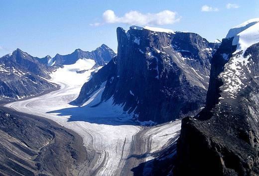
Auyuittuq National Park, located on Baffin Island's Cumberland Peninsula, features the many terrains of Arctic wilderness such as fjords, glaciers, and ice fields. In Inuktitut – the language of Nunavut's Aboriginal people, Inuit – Auyuittuq means "the land that never melts". Although Auyuittuq was established in 1976 as a national park reserve, it was upgraded to a full national park in 2000. Well-known peaks in the park include Mount Asgard and Mount Thor, with a 1,250 m (4,101 ft), 105° face.
The Torngat Mountains National Park Reserve, located on the Labrador Peninsula, covers much of the southern end of the Arctic Cordillera. It protects many of the Arctic wildlife, such as caribou, polar bears, peregrine falcon and the golden eagle. The park was first established on January 22, 2005, making it the first national park to be created in Labrador.
Glaciers and ice caps
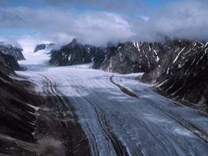
The drier northern section of the Arctic Cordillera is largely covered with ice caps while glaciers are more common at the more humid southern end. Large portions of Ellesmere Island are covered with glaciers and ice, with Manson Icefield and Sydkap in the south; Prince of Wales Icefield and Agassiz Ice Cap along the central-east side of the island, along with substantial ice cover in Northern Ellesmere Island. The northwest coast of Ellesmere Island was covered by a massive, 500 km (310 mi) long ice shelf until the 20th century. The Ellesmere ice shelf reduced by 90 percent in the twentieth century due to global warming, leaving the separate Alfred Ernest, Ayles, Milne, Ward Hunt, and Markham Ice Shelves. A 1986 survey of Canadian ice shelves found that 48 km2 (19 sq mi) 3.3 km3 (0.79 cu mi) of ice calved from the Milne and Ayles ice shelves between 1959 and 1974. The Ward Hunt Ice Shelf, the largest remaining section of thick (greater than 10 m (33 ft)) landfast sea ice along the northern coastline of Ellesmere Island, lost 600 km (370 mi) of ice in a massive calving in 1961-1962. It further decreased by 27% in thickness (13 m, 43 ft) between 1967 and 1999. The breakup of the Ellesmere ice shelves has continued in the 21st century: the Ward Ice Shelf experienced a major breakup during summer 2002; the Ayles Ice Shelf calved entirely on August 13, 2005; the largest breakoff of the ice shelf in 25 years, it may pose a threat to the oil industry in the Beaufort Sea. The piece is 66 km2 (25 sq mi).
The Barnes icecap is found in the central part of the Baffin Island and it has been in retreat since at least the early 1960s when the Geographical Branch of the then Department of Mines & Technical Surveys sent a three-man survey team to the area to measure isostatic rebound and cross-valley features of the Isortoq River.
Geology
The northern portion of the Arctic Cordillera was uplifted during the Innuitian orogeny when the North American Plate moved northward during the mid-Mesozoic. It contains igneous and metamorphic rocks, but for the most part is composed of sedimentary rocks. Mountains on Axel Heiberg Island consist mainly of long ridges of folded mid-Mesozoic and Palaeozoic strata with minor igneous intrusions.
The Arctic Cordillera is younger than the Appalachians, and so erosion has not had time to reduce it to rounded hills. The mountains are also barren because trees can neither survive the extremely cold winter temperatures, nor grow during the short summers. Vast areas are covered by permanent ice and snow. The Arctic Cordillera resembles the Appalachians in composition and contain similar types of minerals. The mineral resources have not been greatly exploited, however, because the region's remote location makes development too costly when cheaper alternatives exist further south.
Mountains on southeastern Ellesmere Island are principally made of granitic gneiss, migmatic, undifferentiated intrusive and volcanic rocks. They are typified by being highly eroded, with conspicuous deep vertical fissures and narrow ledges.
The Arctic Cordillera form the eastern edge of the Canadian Shield, which covers much of Canada's landscape. Precambrian rock is the major component of the bedrock.
Volcanism
Mountains of volcanic rock range in age from 1.2 billion to 65 million years old. The Late Cretaceous Ellesmere Island Volcanics has been uncertainly associated to both the early volcanic activity of the Iceland hotspot and the Alpha Ridge. Even though these volcanics are about 90 million years old, the volcanoes and cinder can still be seen.
The Late Cretaceous Strand Fiord Formation is interpreted to represent the cratonward extension of the Alpha Ridge, a volcanic ridge that was active during the formation of the Amerasian Basin. The formation is part of the thick Sverdrup Basin succession and immediately precedes the final basin foundering event. The Strand Fiord volcanics are encased in marine strata and thin southward from a maximum thickness of more than 789 m (2,589 ft) on northwestern Axel Heiberg to a zero edge near the southern shore of the island. Tholeiitic icelandite basalt flows are the main constituent of the formation with pyroclastic conglomerates, sandstones, mudrocks and rare coal seams are also present. The lava flows range in thickness from 6 to 60 m (20 to 197 ft) and subaerial flows predominate. Both pahoehoe and aa lava types are common and the volcanic pile accumulated mostly by the quiet effusion of lavas. The pyroclastic lithologies become more common near the southern and eastern edges of the formation and represent lahars and beach to shallow marine reworked deposits. The formation contains flood basalts which are found on western Axel Heiberg Island at Dragon Cliffs 300 m (980 ft) tall. It contains columnar jointing units that are usually 1 to 3 m (3 ft 3 in to 9 ft 10 in) in diameter.
The Bravo Lake Formation in central Baffin Island is a rare alkaline-suite that formed as a result of submarine rifting during the Paleoproterozoic period. The lavas of the volcanic belt display geochemical characteristics similar to modern ocean-island-basalt groups. The range from moderately to intensely fractionated REE-profiles is similar to that from tholeiitic basalts to extremely alkaline lavas in Hawaii.
Mountain ranges
Several subranges of the Arctic Cordillera have official names. These are:
Axel Heiberg Island
Baffin Island
Bathurst Island
Bylot Island
Devon Island
Ellesmere Island
Île Vanier
Labrador and Quebec
Flora and fauna
Not much can grow in the severe environment, where killing frost can come at any time during the year and even soil is rare. Three-quarters of the land is bare rock; and even lichen have a hard time of it. Trees are hardly noticeable. Plants that do grow in the region are mostly tiny species that often grow in thick isolating mats to protect themselves from the cold or are covered in thick hairs that help to insulate and to protect them from the harsh wind.
Some of the plant species found are Arctic black spruce, Arctic willow, cottongrass, crustose lichens, kobresia, moss species, wood rush, wire rush, purple saxifrage, Dryas species, sedges, Diapensia lapponica, Arctic poppy, mountain avens, mountain sorrel, river beauty, moss campion, bilberry, and Arctic white heather.
The conditions here are far too severe for reptiles and amphibians to survive, and insects are also rare in the region. Muskoxen and barren-ground caribou are the only large herbivores in this environment, while polar bears and the Arctic wolf are the only large carnivores to be found in the region. Smaller herbivores include the Arctic hare and the collared lemming. Arctic foxes and stoats are some of the smaller carnivores found in the region. Marine mammals include narwhals, beluga whales, walrus, and ringed and bearded seals.
The furry-legged rock ptarmigan is a widespread bird in this region. Typical birds of prey include the gyrfalcon and snowy owl. Some of the more widespread shore and seabirds are the thick-billed murre, black-legged kittiwake, ruddy turnstone, red knot, black guillemot, widespread ringed plover, little ringed plover and northern fulmar. Songbirds found in the Arctic Cordillera include the hoary redpoll, common redpoll, snow bunting, and Lapland longspur. The snow goose, common and king eider, and red-throated loon are some species of waterfowl that live in the region.
Climate
The Arctic Cordillera has one of Canada's most inhospitable climates. During winter, the temperature averages at −35 °C (−31 °F), and is very dark and long, while it is somewhat milder and more humid in the southernmost portions of the cordillera. Only about 2,600 people live in the region, found primarily in the communities of Clyde River, Qikiqtarjuaq (formerly known as Broughton Island), and Pond Inlet. The communities are rather small, with the populations being 820, 473 and 1,315 respectively in 2006. Most of the people who live in the region survive by hunting, fishing, and trapping.
Tree stumps were discovered in 1985 on Axel Heiberg Island dating back 40 million years, indicating this northerly part of the cordillera was warmer and wetter than its present-day climate.