
Highest elevation 1,951 m (6,401 ft) Elevation 1,951 m | Area rank 72nd Area 11,067 km² | |
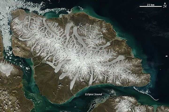 | ||
Bylot Island lies off the northern end of Baffin Island in Nunavut Territory, Canada. Eclipse Sound to the southeast and Navy Board Inlet to the southwest separate it from Baffin Island. Parry Channel lies to its northwest. At 11,067 km2 (4,273 sq mi) it is ranked 71st largest island in the world and Canada's 17th largest island. The island measures 180 km (110 mi) east to west and 110 km (68 mi) north to south and is one of the largest uninhabited islands in the world. While there are no permanent settlements on this Canadian Arctic island, Inuit from Pond Inlet and elsewhere regularly travel to Bylot Island. An Inuit seasonal hunting camp is located southwest of Cape Graham Moore.
Contents
Map of Bylot Island, Baffin, Unorganized, NU, Canada
The island's mountains are part of the Byam Martin Mountains, which is part of the Baffin Mountains of the Arctic Cordillera. In addition to Angilaaq Mountain, Malik Mountain, Mount St. Hans, and Mount Thule are notable. Tay Bay is on the west coast. Vertical cliffs along the coastline are made up of Precambrian dolomite. There are numerous glaciers. The western shore faces Navy Board Inlet. The island's north shore, facing Lancaster Sound, is a polar bear maternity den area. Beluga, bowhead whale, harp seal, narwhal, and ringed seal frequent the area.
The island is named for the Arctic explorer Robert Bylot, who was the first European to sight it in 1616. The whaling captain William Adams was the first to prove the island's insular nature in 1872.
Protected areas
Almost all of the island is within the Sirmilik National Park, harbouring large populations of thick-billed murres, black-legged kittiwakes and greater snow geese. The eastern area of the island is federally designated as the Bylot Island Migratory Bird Sanctuary. Three areas are classified as Canadian Important Bird Areas: Cape Graham Moore, Cape Hay, and the Southwest Bylot plain.