
Elevation 2,147 m | ||
 | ||
Mountains Similar | ||
The Baffin Mountains are a mountain range running along the northeastern coast of Baffin Island and Bylot Island, Nunavut are part of the Arctic Cordillera. The ice-capped mountains are some of the highest peaks of eastern North America, reaching a height of 1,525–2,146 metres (5,003–7,041 ft) above sea level. While they could be considered a single mountain range as they are separated by bodies of water to make Baffin Island, this is not true, as they are closely related to the other mountain ranges that make the much larger Arctic Cordillera mountain range.
Contents
Terrain
The highest point is Mount Odin at 2,147 m (7,044 ft) while Mount Asgard at 2,015 m (6,611 ft) is perhaps the most famous. The highest point in the northern Baffin Mountains is Qiajivik Mountain at 1,963 m (6,440 ft). There are no trees in the Baffin Mountains because the mountains are north of the Arctic tree line. Rocks that comprise the Baffin Mountains are primarily deeply dissected granitic rocks. It was covered with ice until about 1500 years ago, and vast parts of it are still ice-covered. Geologically, the Baffin Mountains form the eastern edge of the Canadian Shield, which covers much of Canada's landscape.
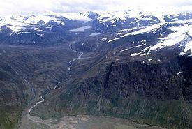
Glaciation
The ranges of the Baffin Mountains are separated by deep fjords and glaciated valleys with many spectacular glacial and ice-capped mountains. The snowfall in the Baffin Mountains is light, much less than in places like the Saint Elias Mountains in southeastern Alaska and southwestern Yukon which are plastered with snow.
The largest ice cap in the Baffin Mountains is the Penny Ice Cap, which has an area of 6,000 km2 (2,300 sq mi). During the mid-1990s, Canadian researchers studied the glacier's patterns of freezing and thawing over centuries by drilling ice core samples.
Flora and fauna
The dominant vegetation in the Baffin Mountains is a discontinuous cover of mosses, lichens and cold-hardy vascular plants such as sedge and cottongrass.
History
One of the first mountaineering expeditions in the Baffin Mountains was in 1934 by J.M Wordie, in which two peaks called Pioneer Peak and Longstaff Tower were climbed.
The Auyuittuq National Park was established in 1976. It features many of Arctic wilderness, such as fjords, glaciers and ice fields. In Inuktitut - the language of Nunavut's Aboriginal people, Inuit - Auyuittuq means "the land that never melts". Although Auyuittuq was established in 1976 as a national park reserve, it was upgraded to a full national park in 2000.
There were Inuit settlements in the Baffin Mountains before European contact. The first European contact is believed to have been by Norse explorers in the 11th century, but the first recorded sighting of Baffin Island was Martin Frobisher during his search for the Northwest Passage in 1576.