
Max. length 74 km (46 mi) Surface area 537.5 km (207.5 sq mi) Area 537.5 km² Length 70 km Width 11 km | Max. width 12 km (7 mi) Surface elevation 158 m Mean depth 280 m Catchment area 4,900 km² | |
 | ||
Primary inflows | ||
Lake Hazen is often called the northernmost lake of Canada, in the northern part of Ellesmere Island, Nunavut, but detailed maps show several smaller lakes up to more than 100 km (62 mi) farther north on Canada's northernmost island. Turnabout Lake is immediately northeast of the northern end of Hazen lake. Still further north are the Upper and Lower Dumbell Lakes, with Upper Dumbell Lake 5.2 km (3 mi) southwest of Alert, Canada's northernmost settlement on the coast of Lincoln Sea, Arctic Ocean.
Contents
Map of Lake Hazen, Baffin, Unorganized, NU, Canada
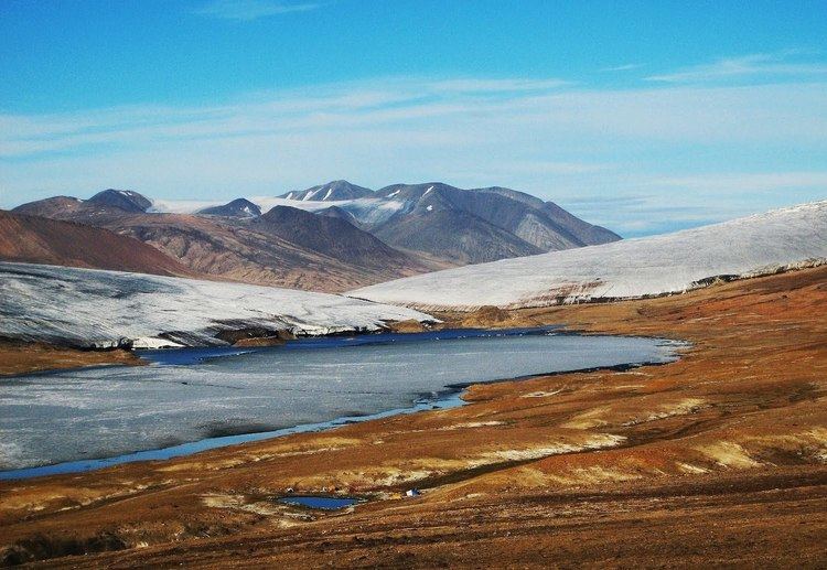
The northeastern end of Lake Hazen is 118 km (73 mi) southwest of Alert. Lake Hazen is the world's largest lake north of the Arctic Circle by volume. By surface area, it is third largest, after Lake Taymyr in Russia and Lake Inari in Finland. Lake Hazen is 74 km (46 mi) long and up to 12 km (7 mi) wide, with an area of 537.5 km2 (207.5 sq mi). It stretches in a southwest-northeast direction from 81°40′N 72°58′W to 81°56′N 68°55′W. The lake is up to 269 m (883 ft) deep and has an estimated volume of 51.4 km3. The shoreline is 185 km (115 mi) long and 158 m (518 ft) above sea level. It has several islands, the largest of them being Johns Island, which is 7 km (4.3 mi) long and less than 1 km (0.62 mi) wide, also extending in a southwest-northeast direction like the lake itself. Other islands include Gatter Island, Clay Island (both close to the northeastern shore), Whisler Island, and Dyas Island (both close to the southern shore). The lake is covered by ice about ten months a year. It is fed by glaciers from the surrounding Eureka Uplands (Palaeozoic rocks north of the lake, rising up to 2,500 m (8,200 ft) above sea level), most importantly Henrietta Nesmith and the Gilmour Glaciers, and drained by 15 km (9.3 mi) long Ruggles River which flows into Chandler Fjord on the northern east coast of Ellesmere Land. The lake is flanked by the Arctic Cordillera.
The area around the lake is a thermal oasis within a polar desert, with summer temperatures up to 20 °C (68 °F).
The lake is part of Quttinirpaaq National Park.
Artifacts of Thule civilization were discovered near Lake Hazen in 2004. Thule preceded the Inuit. In 1882, Augustus Greely discovered the lake during his expedition 1881-1883. Greely's base camp for the exploration was Fort Conger at the northeastern shore of Ellesmere Island, at 81°44′N 64°44′W, which was established as part of the first International Polar Year. Greely named the lake in honor of general William Babcock Hazen, who had organized the expedition. Camp Hazen was established on the northern shore of the lake in 1957 during the International Geophysical Year (IGY), and has been used by various scientific parties since then.
Lake Hazen is populated by a larger and a smaller morphotype of Arctic char. Recent studies indicate they are not anadromous, though Inuit traditional knowledge states otherwise.
Named Inflows
All named rivers and creeks are listed in a clockwise manner, starting in the south:
At the southwestern end (from south to north):
On the northwest coast (from southwest to northeast):
At the northeast end (from north to south):
On the southeast coast (only in the southwest, near the southwest end of the lake):
Tourism
Hikers can start their hiking trips at Lake Hazen itself, or from Tanquary Fiord warden station at Tanquary Fiord Airport 70 km (43 mi) southwest of the lake.