
Topo map NTS 340D/15 Elevation 2,616 m Prominence 2,616 m | Easiest route basic snow climb First ascent 5 June 1967 | |
 | ||
Listing Highest ocean islands 37thNorth America prominent peaks 31stNorth America isolated peaks 13thCanada most prominent peaks 11thCanada most isolated peaks 1st Similar Mount Caubvick, Mount Odin, Qiajivik Mountain, Osborn Range | ||
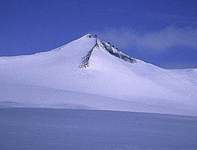
Barbeau Peak is a mountain in Qikiqtaaluk, Nunavut, Canada. Located on Ellesmere Island within Quttinirpaaq National Park, it is the highest mountain in Nunavut and the Canadian Arctic. The mountain was named in 1969 for Dr. Marius Barbeau (1883-1969), a Canadian anthropologist whose research into First Nations and Inuit cultures gained him international acclaim.
Map of Barbeau Peak, Baffin, Unorganized, NU, Canada
Barbeau Peak is characterized by deep and long crevasses, razor thin ridges and highly variable and volatile weather.
Barbeau Peak is the highest mountain within the British Empire Range as well as the Arctic Cordillera, as well as in all of eastern North America.
Barbeau Peak was first climbed on 7 June 1967 by British geologist/glaciologist Geoffrey Hattersley-Smith as part of a joint Defence Research Board/Royal Air Force field party. The party both named the peak and determined its height.
The second ascent was by an eight-man American team in June 1982 (Errington,Trafton AAC 1983) via the north ridge. Subsequent ascents have been made in 1992, 1998, 2000 and 2002, though as of 2006 only seven successful summits have been attained.