
Elevation 4,372 m | Area 44,530 km² | |
 | ||
Length 242 mi (389 km) north-south Width 120 mi (190 km) east-west Mountains | ||
Sangre de cristo mountains
The Sangre de Cristo Mountains (Spanish for "Blood of Christ") are the southernmost subrange of the Rocky Mountains. They are located in southern Colorado and northern New Mexico in the United States. The mountains run from Poncha Pass in South-Central Colorado, trending southeast and south, ending at Glorieta Pass, southeast of Santa Fe, New Mexico. The mountains contain a number of fourteen thousand foot peaks in the Colorado portion, as well as all the peaks in New Mexico which are over thirteen thousand feet.
Contents
- Sangre de cristo mountains
- Map of Sangre de Cristo Mountains Colorado 81152 USA
- Day hike aspen vista sangre de cristo mountains santa fe new mexico usa
- Land management and recreation overview
- Subranges
- Sangre de Cristo Range
- Crestones
- Spanish Peaks
- Culebra Range
- Taos Mountains
- Cimarron Range
- Rincon Mountains
- Santa Fe Mountains
- References
Map of Sangre de Cristo Mountains, Colorado 81152, USA
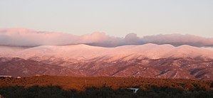
The name of the mountains may refer to the occasional reddish hues observed during sunrise and sunset, and when alpenglow occurs, especially when the mountains are covered with snow. Although the particular origin of the name is unclear, it has been in use since the early 19th century. Before that time the terms "La Sierra Nevada", "La Sierra Madre", "La Sierra", and "The Snowies" (used by English speakers) were used. According to tradition, "sangre de Cristo" were the last words of a Catholic priest who was killed by Indians. Sometimes the archaic Spanish spelling "Christo" is used.
Day hike aspen vista sangre de cristo mountains santa fe new mexico usa
Land management and recreation overview
Much of the mountains are within various National Forests: the Rio Grande and San Isabel in Colorado, and the Carson and Santa Fe in New Mexico. These publicly accessible areas are popular for hunting, camping, hiking, mountain biking, backpacking, climbing, and cross-country and downhill skiing.
The mountains include two large wilderness areas, the Sangre de Cristo Wilderness in Colorado and the Pecos Wilderness in New Mexico, as well as some smaller wilderness areas, such as Latir Peak Wilderness. The Great Sand Dunes National Park and Preserve lies on the southwest side of the mountains in Colorado.
Subranges
The Sangre de Cristo Mountains are divided into various subranges, described here from north to south. Use of the terms "Sangre de Cristo Range" and "Sangre de Cristo Mountains" is inconsistent and either may refer to either the northernmost subrange, the southernmost subrange, or the mountains as a whole.
Sangre de Cristo Range
The Sangre de Cristo Range, the largest and most northerly subrange of the Sangre de Cristo Mountains, runs directly along the east side of the Rio Grande Rift, extending southeast from Poncha Pass for about 75 miles (120 km) through south-central Colorado to La Veta Pass, approximately 20 miles (32 km) west of Walsenburg. They form a high ridge separating the San Luis Valley on the west from the watershed of the Arkansas River on the east.
Crestones
The Crestones are a group of four 14,000+ foot (4,268+ m) peaks (fourteeners) in the Sangre de Cristo Range above Crestone, Colorado.
Spanish Peaks
The Spanish Peaks are a pair of volcanic mountains, West Spanish Peak, 13,626 feet/4,153 m, and East Spanish Peak, 12,860 feet/3,920 m, located in southwestern Huerfano County, Colorado. The Spanish Peaks were designated a National Natural Landmark in 1976 as one of the best known examples of igneous dikes. The mountains can be seen as far north as Colorado Springs (133 miles), as far west as Alamosa (50 miles), points south to Raton, New Mexico (65 miles), and points east to La Junta, Colorado (85 miles).
Culebra Range
The Culebra Range runs almost due north and south, with its northern limit at La Veta Pass in Colorado, and its southern limit at Costilla Creek, just south of Big Costilla Peak in New Mexico. Its highest point is Culebra Peak (14,047 feet/4,282 m), which is notable for being the only fourteener in Colorado which is on private land. Climbers wishing to ascend Culebra must pay a fee (currently US$100 per person), and the number of climbers per year is limited. Standing to the east of the main crest are the two prominent Spanish Peaks (West: 13,626 feet/4,153 m; East: 12,860 feet/3,920 m). Unlike the rest of the Sangre de Cristo Mountains, these are volcanic, with conical shapes and prominent dikes radiating outward. These peaks were important landmarks on the mountain branch of the Santa Fe Trail.
Taos Mountains
The Taos Mountains span the western lobe of the range from Costilla Creek in the north, to Tres Ritos in the south. They include the highest point in New Mexico, Wheeler Peak 13,161 feet (4,011 m), which is part of the small Wheeler Peak Wilderness. Other notable peaks include Pueblo Peak 12,305 feet (3,751 m), which rises dramatically above Taos Pueblo, and Latir Peak 12,708 feet (3,873 m). Williams Lake is located below Wheeler Peak in the Wheeler Peak Wilderness.
Taos Ski Valley lies just to the west of Wheeler Peak. Much of the central portion of the Taos Mountains are on Taos Pueblo land. As viewed from Taos, they are locally called "Taos Mountain."
The southern portion of the Taos Mountains, between Palo Flechado Pass and Tres Ritos (US Route 64 and NM Route 518), is lower and less dramatic than the northern section, with its high point being Cerro Vista, 11,939 ft (3,639 m). The Fernando Mountains are a small subrange lying in this section, just south of US Route 64.
Cimarron Range
The Cimarron Range lies across the Moreno Valley to the east of the Taos Mountains. It is a lower range, with its highest point being Baldy Mountain (12,441 feet/3,792 m). The Philmont Scout Ranch lies on the east side of the Cimarron Range.
Rincon Mountains
This is a minor subrange, significantly lower than the rest of the Sangre de Cristos; it lies east of the southernmost portion of the Taos Mountains.
Santa Fe Mountains
Rounding out the Sangre de Cristo Mountains are the Santa Fe Mountains, which include all peaks south of NM Route 518. This group lies near Santa Fe and surrounds the Pecos Wilderness, which protects the source watershed of the Pecos River. The peaks include Truchas Peak (13,102 feet/3,994 m) as their highest point. Other notable peaks are Santa Fe Baldy (12,622 feet/3,847 m) and Jicarita Peak (12,835 feet/3,912 m). The Pecos Wilderness is crossed by many trails and is popular for backpacking and for fishing in its high alpine lakes.