
- elevation 9,728 ft (2,965 m) Length 2,364 km | - elevation 108 ft (33 m) Discharge 1,147 m³/s | |
 | ||
- left Tributaries Canadian River, Cimarron River, Neosho River | ||
The Arkansas River is a major tributary of the Mississippi River. It generally flows to the east and southeast as it traverses the US states of Colorado, Kansas, Oklahoma, and Arkansas. The river's source basin lies in the western United States in Colorado, specifically the Arkansas River Valley, where the headwaters derive from the snowpack in the Sawatch and Mosquito mountain ranges. It then flows east into the Midwest via Kansas, and finally into the South through Oklahoma and Arkansas.
Contents
- Map of Arkansas River United States
- PronunciationsEdit
- HydrographyEdit
- Allocation problemsEdit
- Riverway commerceEdit
- The river in historyEdit
- AnglingEdit
- References
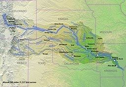
Map of Arkansas River, United States
At 1,469 miles (2,364 km), it is the sixth-longest river in the United States, the second-longest tributary in the Mississippi–Missouri system, and the 45th longest river in the world. Its origin is in the Rocky Mountains in Lake County, Colorado, near Leadville. In 1859, placer gold discovered in the Leadville area brought thousands seeking to strike it rich, but the easily recovered placer gold was quickly exhausted. The Arkansas River's mouth is at Napoleon, Arkansas, and its drainage basin covers nearly 170,000 sq mi (440,300 km²). In terms of volume, the river is much smaller than the Missouri and Ohio Rivers, with a mean discharge of roughly 41,000 cubic feet per second (1,200 m3/s).
The Arkansas from its headwaters to the 100th meridian west formed part of the US-Mexico border from the Adams–Onís Treaty (in force 1821) until the Texas Annexation or Treaty of Guadalupe Hidalgo.
PronunciationsEdit
Name pronunciation varies by region. Many people in western states, including Kansas and Colorado, pronounce it /ɑːrˈkænzəs/ ar-KAN-zəs, while many other people in Oklahoma and Arkansas typically pronounce it /ˈɑːrkənsɔː/ AR-kən-saw according to a state law passed in 1881.
HydrographyEdit
The Arkansas has three distinct sections in its long path through central North America. At its headwaters, the Arkansas runs as a steep fast-flowing mountain river through the Rockies in its narrow valley, dropping 4,600 feet (1.4 km) in 120 miles (193 km). This section supports extensive whitewater rafting, including The Numbers (near Granite, Colorado), Brown's Canyon, and the Royal Gorge.
At Cañon City, Colorado, the Arkansas River valley widens and flattens markedly. Just west of Pueblo, Colorado, the river enters the Great Plains. Through the rest of Colorado, Kansas, and much of Oklahoma, it is a typical Great Plains riverway, with wide, shallow banks subject to seasonal flooding and periods of dwindling flow. Tributaries include the Cimarron River and the Salt Fork Arkansas River.
In eastern Oklahoma the river begins to widen further into a more contained consistent channel. To maintain more reliable flow rates, a series of large reservoir lakes have been built on the Arkansas and its intersecting tributaries including the Canadian, Verdigris, Neosho (Grand), Illinois, and the Poteau rivers. These locks and dams allow the river to be navigable by barges and large river craft downriver of Muskogee, Oklahoma, where the McClellan-Kerr Arkansas River Navigation System joins in with the Verdigris River.
Into western Arkansas, the river path works between the encroaching Boston and Ouachita Mountains, including many isolated, flat-topped mesas, buttes, or monadnocks such as Mount Nebo, Petit Jean Mountain, and Mount Magazine, the highest point in the state. The river valley then expands as it encounters much flatter land beginning just west of Little Rock, Arkansas. It continues eastward across the plains and forests of eastern Arkansas until it flows into the Mississippi River.
Water flow in the Arkansas River (as measured in central Kansas) has dropped from approximately 248 cubic feet per second (7 m³/s) average from 1944-1963 to 53 cubic feet per second (1.5 m³/s) average from 1984–2003, largely because of the pumping of groundwater for irrigation in eastern Colorado and western Kansas.
Important cities along the Arkansas River include Pueblo, Colorado, Garden City, Kansas, Wichita, Kansas, Tulsa, Oklahoma, Fort Smith, Arkansas, and Little Rock, Arkansas.
The I-40 bridge disaster of May 2002 took place on I-40's crossing of Kerr Reservoir on the Arkansas River near Webbers Falls, Oklahoma.
Allocation problemsEdit
Since 1902, Kansas has claimed Colorado takes too much of the river's water, resulting in a number of lawsuits before the US Supreme Court that continue to this day, generally under the name of Kansas v. Colorado. The problems over the possession and use of Arkansas River water by Colorado and Kansas led to the creation of an interstate compact or agreement between the two states. While Congress approved the Arkansas River Compact in 1949, the compact did not stop further disputes by the two states over water rights to the river.
The Kansas-Oklahoma Arkansas River Basin Compact was created in 1965 to promote mutual consideration and equity over water use in the basin shared by those states. It led to the Kansas-Oklahoma Arkansas River Commission, which was charged with administering the compact and reducing pollution. The compact was approved and implemented by both states in 1970, and has been in force since then.
Riverway commerceEdit
The McClellan-Kerr Arkansas River Navigation System begins at the Tulsa Port of Catoosa on the Verdigris River, enters the Arkansas near Muskogee, and runs via an extensive lock and dam system to the Mississippi River.
Through Oklahoma and Arkansas, dams artificially deepen and widen the river to build it into a commercially navigable body of water. From the mouth of the Verdigris, to the point downstream where the McClellan-Kerr system moves over to the White River near Arkansas Post in far eastern Arkansas, the Arkansas sustains commercial barge traffic and offers passenger and recreational use through what is often little more than a series of reservoirs.
The river in historyEdit
Many nations of Native Americans lived near, or along, the 1,450-mile (2334-km) stretch of the Arkansas River for thousands of years. The first Europeans to see the river were members of the Spanish Coronado expedition on June 29, 1541. Also in the 1540s, Hernando de Soto discovered the junction of the Arkansas with the Mississippi. The Spanish originally called the river Napeste. "The name "Arkansas" was first applied by Father Jacques Marquette, who called the river Akansa in his journal of 1673. The Joliet-Marquette expedition travelled the Mississippi River from Prairie du Chien, Wisconsin towards the Gulf of Mexico, but turned back at the mouth of the Arkansas River. By that time, they had encountered Native Americans carrying European trinkets, and feared confrontation with Spanish conquistadors.
In 1819, the Adams-Onís Treaty set the Arkansas as part of the frontier between the United States and Spanish Mexico. This continued until the United States annexed Texas after the Mexican-American War, in 1846.
Later, the Santa Fe Trail followed the Arkansas through much of Kansas, picking it up near Great Bend and continuing through to La Junta, Colorado, unless users elected to take the challenging Cimarron Cutoff in Cimarron, Kansas.
In the 1880s, Charles "Buffalo" Jones, one of the cofounders of Garden City, Kansas, organized four irrigation companies to take water one hundred miles from the Arkansas River to cultivate 75,000 acres (300 km2) of land.
AnglingEdit
The headwaters of the Arkansas River in central Colorado have been known for exceptional trout fishing, particularly fly fishing, since the 19th century, when greenback cutthroat trout dominated the river. Today, brown trout dominate the river, which also contains rainbow trout. Trout Unlimited considers the Arkansas one of the top 100 trout streams in America, a reputation the river has had since the 1950s. From Leadville to Pueblo, the Arkansas River is serviced by numerous fly shops and guides operating in Buena Vista, Salida, Cañon City and Pueblo. The Colorado Division of Wildlife provides regular online fishing reports for the river.
A fish kill occurred on December 29, 2010, in which an estimated 100,000 freshwater drum lined the Arkansas River bank. An investigation, conducted by the Arkansas Game and Fish Commission, found the dead fish "cover 17 miles of river from the Ozark Lock and Dam downstream to River Mile 240, directly south of Hartman, Arkansas." Tests later indicated the likely cause of the kill was gas bubble trauma caused by opening the spillways on the Ozark Dam.