
Elevation 13,626 ft (4,153 m) Country United States of America | Designated as world heritage site 1976 | |
 | ||
Mountains West Spanish Peak, East Spanish Peak, Huerfano Butte | ||
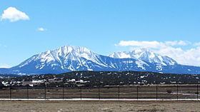
The Spanish Peaks are a pair of prominent mountains located in southwestern Huerfano County, Colorado. The Ute Indians named them Huajatolla (pronounced Wa-ha-toy-a), meaning "two breasts" or "breasts of the Earth".
Map of Spanish Peaks, Colorado 81020, USA
The two peaks, West Spanish Peak (13,626 feet or 4,153 meters) and East Spanish Peak (12,683 feet or 3,866 meters), are east of, and separate from, the Culebra Range of the Sangre de Cristo Mountains. West Spanish Peak is the easternmost mountain over 4,000 meters in the United States.
The Spanish Peaks were formed by two separate shallow (or hypabyssal) igneous intrusions during the Late-Oligocene epoch of the Paleogene Period. West Spanish Peak is an older (24.59 +/- 0.13 Ma) quartz syenite while East Spanish Peak (23.36 +/- 0.18 Ma) is composed of granite and granodiorite porphyry.
The Spanish Peaks were designated a National Natural Landmark in 1976 as one of the best known examples of igneous dikes.
They were an important landmark on the Santa Fe Trail. The mountains can be seen as far north as Colorado Springs (133 miles (214 km)), as far west as Alamosa (85 miles (137 km)), points south to Raton, New Mexico (65 miles (105 km)), and points east of Trinidad (up to 15 miles (24 km)).
The Spanish Peaks Wilderness area of 17,855 acres (72.3 km2) encompasses the summits of both Spanish peaks. Hiking is popular in the wilderness area.