
Area 249.4 km² Region East of England | Population 246,139 (2013) Founded Anglo-Saxon period | |
 | ||
Points of interest Nauticus, USS Wisconsin (BB-64), Chrysler Museum of Art, Norfolk Botanical Garden, Town Point Park Colleges and Universities Old Dominion University (Norfolk), Norfolk State University (Norfolk), Tidewater Community College (Norfolk), Eastern Virginia Medical School (Norfolk), Virginia Wesleyan College (Norfolk) | ||
Map of Norfolk
Norfolk is a county in East Anglia in England. It borders Lincolnshire to the west and north-west, Cambridgeshire to the west and southwest, and Suffolk to the south. Its northern and eastern boundaries are the North Sea and, to the north-west, The Wash. The county town is Norwich. With an area of 2,074 square miles (5,370 km2) and a population of 859,400, Norfolk is a largely rural county with a population density of 401 per square mile (155 per km²). Of the county's population, 40% live in four major built up areas: Norwich (213,000), Great Yarmouth (63,000), King's Lynn (46,000) and Thetford (25,000).
Contents
- Map of Norfolk
- Best place on earth norfolk island
- Norfolk va the place where life is celebrated daily
- History
- Management of the shoreline
- Economy and industry
- Primary and secondary education
- Tertiary education
- Local
- Norwich Unitary Authority dispute
- Westminster
- Settlements
- Transport
- Dialect accent and nickname
- Tourism
- Amusement parks and zoos
- Theatres
- Notable people from Norfolk
- People associated with Norfolk
- Food drink visit norfolk england
- Norfolk county fair and horse show midway rides fair food
- References
The Broads is a network of rivers and lakes in the east of the county, extending south into Suffolk. The area is not a National Park although it is marketed as such. It has similar status to a national park, and is protected by the Broads Authority.
Best place on earth norfolk island
Norfolk va the place where life is celebrated daily
History
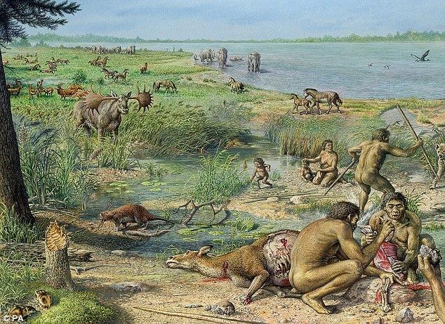
Norfolk was settled in pre-Roman times, with camps along the higher land in the west, where flints could be quarried. A Brythonic tribe, the Iceni, inhabited the county from the 1st century BC to the end of the 1st century AD. The Iceni revolted against the Roman invasion in AD 47, and again in 60 led by Boudica. The crushing of the second rebellion opened the county to the Romans. During the Roman era roads and ports were constructed throughout the county and farming was widespread.
Situated on the east coast, Norfolk was vulnerable to invasions from Scandinavia and Northern Europe, and forts were built to defend against the Angles and Saxons. By the 5th century the Angles, after whom East Anglia and England itself are named, had established control of the region and later became the "north folk" and the "south folk", hence, "Norfolk" and "Suffolk". Norfolk, Suffolk and several adjacent areas became the kingdom of East Anglia (one of the heptarchy), which later merged with Mercia and then with Wessex. The influence of the Early English settlers can be seen in the many place names ending in "-ton" and "-ham". Endings such as "-by" and "-thorpe" are also common, indicating Danish place names: in the 9th century the region again came under attack, this time from Danes who killed the king, Edmund the Martyr. In the centuries before the Norman Conquest the wetlands of the east of the county began to be converted to farmland, and settlements grew in these areas. Migration into East Anglia must have been high: by the time of the Domesday Book survey it was one of the most densely populated parts of the British Isles. During the high and late Middle Ages the county developed arable agriculture and woollen industries. Norfolk's prosperity at that time is evident from the county's large number of medieval churches: out of an original total of over one thousand, 659 have survived, more than in the whole of the rest of Great Britain. The economy was in decline by the time of the Black Death, which dramatically reduced the population in 1349. By the 16th century Norwich had grown to become the second largest city in England; but over one-third of its population died in the plague epidemic of 1579, and in 1665 the Great Plague again killed around one-third of the population. During the English Civil War Norfolk was largely Parliamentarian. The economy and agriculture of the region declined somewhat. During the Industrial Revolution Norfolk developed little industry except in Norwich which was a late addition to the railway network.
In the 20th century the county developed a role in aviation. The first development in airfields came with the First World War; there was then a massive expansion during the Second World War with the growth of the Royal Air Force and the influx of the American USAAF 8th Air Force which operated from many Norfolk airfields. During the Second World War agriculture rapidly intensified, and it has remained very intensive since, with the establishment of large fields for growing cereals and oilseed rape.
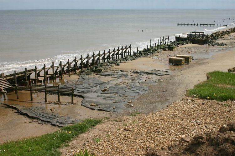
Management of the shoreline
Norfolk's low-lying land and easily eroded cliffs, many of which are chalk and clay, make it vulnerable to the sea; the most recent major event was the North Sea flood of 1953. The low-lying section of coast between Kelling and Lowestoft Ness in Suffolk is currently managed by the Environment Agency to protect the Broads from sea flooding. Management policy for the North Norfolk coastline is described in the North Norfolk Shoreline Management Plan, which was published in 2006 but has yet to be accepted by the local authorities. The Shoreline Management Plan states that the stretch of coast will be protected for at least another 50 years, but that in the face of sea level rise and post-glacial lowering of land levels in the South East, there is an urgent need for further research to inform future management decisions, including the possibility that the sea defences may have to be realigned to a more sustainable position. Natural England have contributed some research into the impacts on the environment of various realignment options. The draft report of their research was leaked to the press, who created great anxiety by reporting that Natural England plan to abandon a large section of the Norfolk Broads, villages and farmland to the sea to save the rest of the Norfolk coastline from the impact of climate change.
Economy and industry
In 1998 Norfolk had a Gross Domestic Product of £9,319 million, which represents 1.5% of England's economy and 1.25% of the United Kingdom's economy. The GDP per head was £11,825, compared to £13,635 for East Anglia, £12,845 for England and £12,438 for the United Kingdom. In 1999–2000 the county had an unemployment rate of 5.6%, compared to 5.8% for England and 6.0% for the UK.
Important business sectors include tourism, energy (oil, gas and renewables), advanced engineering and manufacturing, and food and farming.
Much of Norfolk's fairly flat and fertile land has been drained for use as arable land. The principal arable crops are sugar beet, wheat, barley (for brewing) and oil seed rape. The county also boasts a saffron grower. Over 20% of employment in the county is in the agricultural and food industries.
Well-known companies in Norfolk are Aviva (formerly Norwich Union), Colman's (part of Unilever), Lotus Cars and Bernard Matthews Farms. The Construction Industry Training Board is based on the former airfield of RAF Bircham Newton. The BBC East region is centred on Norwich, although it covers an area as far west as Milton Keynes; the BBC does however provide BBC Radio Norfolk solely for the county.
A Local Enterprise Partnership has recently been established by business leaders to help grow jobs across Norfolk and Suffolk. They have secured an enterprise zone to help grow businesses in the energy sector, and established the two counties as a centre for growing services and products for the green economy.
To help local industry in Norwich, the local council offered a wireless internet service but this has now been withdrawn as funding has ceased.
Primary and secondary education
Norfolk has a completely comprehensive state education system, with secondary school age from 11 to 16 or in some schools with sixth forms, 18 years old. In many of the rural areas, there is no nearby sixth form and so sixth form colleges are found in larger towns. There are twelve independent, or private schools, including Gresham's School in Holt in the north of the county, Thetford Grammar School in Thetford which is Britain's fifth oldest extant school, Langley School in Loddon, and several in the city of Norwich, including Norwich School and Norwich High School for Girls. The King's Lynn district has the largest school population. Norfolk is also home to Wymondham College, the UK's largest remaining state boarding school.
Tertiary education
The University of East Anglia is located on the outskirts of Norwich and Norwich University of the Arts is based in seven buildings in and around St George's Street in the city centre, next to the River Wensum.
The City College Norwich and the College of West Anglia are colleges covering Norwich and King's Lynn as well as Norfolk as a whole. Easton & Otley College, 7 miles (11 km) west of Norwich, provides agriculture-based courses for the county, parts of Suffolk and nationally.
University Campus Suffolk also run higher education courses in Norfolk, from multiple locations including Great Yarmouth College.
Local
Norfolk is under the control of Norfolk County Council and is also divided into seven local government districts: Breckland District, Broadland District, Great Yarmouth Borough, King's Lynn and West Norfolk Borough, North Norfolk District, Norwich City and South Norfolk District. As of 2014 the Conservatives controlled five of the seven districts, while Norwich is controlled by Labour and Great Yarmouth is under no overall control.
The county is traditionally a stronghold for the Conservatives, who have always won at least 50% of Norfolk's parliamentary constituencies since 1979. The countryside is mostly solid Conservative territory, with a few areas being strong for the Liberal Democrats. From 1995 to 2007, South Norfolk was run by the Liberal Democrats, but the district switched back to the Conservatives in a landslide in 2007.
Norfolk's urban areas are more mixed, although Norwich and central parts of Great Yarmouth and King's Lynn are strong for the Labour Party. This said, Labour's dominance in Norwich has recently been stemmed by the Green Party, who are now the official opposition on Norwich City Council and also hold several divisions within the city on Norfolk County Council.
Norfolk County Council had been under Conservative control since 1997, but they lost overall control at the 2013 election, when the Conservatives lost 20 seats and UKIP gained 14. As at 2013 there are 40 Conservative councillors, 15 UKIP, 14 Labour, 10 Liberal Democrats, 4 Green Party and one independent. Although the Conservatives had been expected to form a minority administration or to seek a coalition with the Liberal Democrats, both scenarios failed to materialise. Eventually, a rainbow alliance between Labour, the Liberal Democrats, Greens and UKIP was formed, with the cabinet composed solely of Labour and Liberal Democrats.
Norwich Unitary Authority dispute
In October 2006, the Department for Communities and Local Government produced a Local Government White Paper inviting councils to submit proposals for unitary restructuring. In January 2007 Norwich submitted its proposal, which was rejected in December 2007 as it did not meet the criteria for acceptance. In February 2008, the Boundary Committee for England (from 1 April 2010 incorporated in the Local Government Boundary Commission for England) was asked to consider alternative proposals for the whole or part of Norfolk, including whether Norwich should become a unitary authority, separate from Norfolk County Council. In December 2009, the Boundary Committee recommended a single unitary authority covering all of Norfolk, including Norwich.
However, on 10 February 2010, it was announced that, contrary to the December 2009 recommendation of the Boundary Committee, Norwich would be given separate unitary status. The proposed change was strongly resisted, principally by Norfolk County Council and the Conservative opposition in Parliament. Reacting to the announcement, Norfolk County Council issued a statement that it would seek leave to challenge the decision in the courts. A letter was leaked to the local media in which the Permanent Secretary for the Department for Communities and Local Government noted that the decision did not meet all the criteria and that the risk of it "being successfully challenged in judicial review proceedings is very high". The Shadow Local Government and Planning Minister, Bob Neill, stated that should the Conservative Party win the 2010 general election, they would reverse the decision.
Following the 2010 general election, Eric Pickles was appointed Secretary of State for Communities and Local Government on 12 May 2010 in a Conservative–Liberal Democrat coalition government. According to press reports, he instructed his department to take urgent steps to reverse the decision and maintain the status quo in line with the Conservative Party manifesto. However, the unitary plans were supported by the Liberal Democrat group on the city council, and by Simon Wright, LibDem MP for Norwich South, who intended to lobby the party leadership to allow the changes to go ahead.
The Local Government Act 2010 to reverse the unitary decision for Norwich (and Exeter and Suffolk) received Royal Assent on 16 December 2010. The disputed award of unitary status had meanwhile been referred to the High Court, and on 21 June 2010 the court (Mr. Justice Ouseley, judge) ruled it unlawful, and revoked it. The city has therefore failed to attain permanent unitary status, and the previous two-tier arrangement of County and District Councils (with Norwich City Council counted among the latter) remains the status quo.
Westminster
Following the May 2015 General Election, Norfolk is represented in the House of Commons by seven Conservative members of parliament, one Labour Member of Parliament and one Liberal Democrat.
[1] Green, LCA, Independents, Others
[2] UKIP, LCA, Independents, Others
Settlements
Norfolk's county town and only city is Norwich, one of the largest settlements in England during the Norman era. Norwich is home to the University of East Anglia, and is the county's main business and culture centre. Other principal towns include the port-town of King's Lynn and the seaside resort and Broads gateway town of Great Yarmouth.
Based on the 2011 Census the county's largest centres of population are: Norwich (213,166), Great Yarmouth (63,434), King's Lynn (46,093), Thetford (24,883), Dereham (20,651), Wymondham (13,587), North Walsham (12,463), Attleborough (10,549), Downham Market (9,994), Diss (9,829), Fakenham (8,285), Cromer (7,749), Sheringham (7,367) and Swaffham (7,258). There are also several smaller market towns: Aylsham (6,016), Harleston (4,458) and Holt (3,810).
Much of the county remains rural in nature and Norfolk is believed to have around 200 lost settlements which have been largely or totally depopulated since the medieval period. These include places lost to coastal erosion, agricultural enclosure, depopulation and the establishment of the Stanford Training Area in 1940.
Transport
Norfolk is one of the few counties in England that does not have a motorway. The A11 connects Norfolk to Cambridge and London via the M11. From the west there only two routes from Norfolk that have a direct link with the A1, the A47 which runs into the East Midlands and to Birmingham via Peterborough and the A17 which runs into the East Midlands via Lincolnshire. These two routes meet at King's Lynn which is also the starting place for the A10 which provides West Norfolk with a direct link to London via Ely, Cambridge and Hertford . The Great Eastern Main Line is a major railway from London Liverpool Street Station to Essex, Suffolk and Norfolk. Norwich International Airport offers flights within Europe including a link to Amsterdam which offers onward flights throughout the world.
Dialect, accent and nickname
The Norfolk dialect is also known as "Broad Norfolk", although over the modern age much of the vocabulary and many of the phrases have died out due to a number of factors, such as radio, TV and people from other parts of the country coming to Norfolk. As a result, the speech of Norfolk is more of an accent than a dialect, though one part retained from the Norfolk dialect is the distinctive grammar of the region.
People from Norfolk are sometimes known as Norfolk Dumplings, an allusion to the flour dumplings that were traditionally a significant part of the local diet.
More cutting, perhaps, was the pejorative medical slang term "Normal for Norfolk", alluding to the county's perceived status as a quirky rustic backwater.
Tourism
Norfolk is a popular tourist destination and has several major holiday attractions. There are many seaside resorts, including some of the finest British beaches, such as those at Great Yarmouth, Cromer and Holkham. Norfolk contains the Broads and other areas of outstanding natural beauty and many areas of the coast are wild bird sanctuaries and reserves with some areas designated as National Parks such as the Norfolk Coast AONB.
The Queen's residence at Sandringham House in Sandringham, Norfolk provides an all year round tourist attraction whilst the coast and some rural areas are popular locations for people from the conurbations to purchase weekend holiday homes. Arthur Conan Doyle first conceived the idea for The Hound of the Baskervilles whilst holidaying in Cromer with Bertram Fletcher Robinson after hearing local folklore tales regarding the mysterious hound known as Black Shuck.
Amusement parks and zoos
Norfolk has several amusement parks and zoos.
Theatres
The Pavilion Theatre (Cromer) is a 510-seater venue on the end of Cromer Pier, best known for hosting the 'end-of-the-pier' show, the Seaside Special. The theatre also presents comedy, music, dance, opera, musicals and community shows.
The Britannia Pier Theatre (Great Yarmouth) mainly hosts popular comedy acts such as the Chuckle Brothers and Jim Davidson. The theatre has 1,200 seats and is one of the largest in Norfolk.
The Theatre Royal (Norwich) has been on its present site for nearly 250 years, the Act of Parliament in the tenth year of the reign of George II having been rescinded in 1761. The 1,300-seat theatre, the largest in the city, hosts a mix of national touring productions including musicals, dance, drama, family shows, stand-up comedians, opera and pop.
The Norwich Playhouse (Norwich) hosts theatre, comedy, music and other performing arts. It has a seating capacity of 300.
The Maddermarket Theatre (Norwich) opened in 1921 and was the first permanent recreation of an Elizabethan theatre. The founder was Nugent Monck who had worked with William Poel. The theatre has a seating capacity of 312.
The Norwich Puppet Theatre (Norwich) was founded in 1979 by Ray and Joan DaSilva as a permanent base for their touring company and was first opened as a public venue in 1980, following the conversion of the medieval church of St. James in the heart of Norwich. Under subsequent artistic directors – Barry Smith and Luis Z. Boy – the theatre established its current pattern of operation. It is a nationally unique venue dedicated to puppetry, and currently houses a 185-seat raked auditorium, 50 seat Octagon Studio, workshops, an exhibition gallery, shop and licensed bar. It is the only theatre in the Eastern region with a year-round programme of family-centred entertainment.
The Garage studio theatre (Norwich) can seat up to 110 people in a range of different layouts. It can also be used for standing events and can accommodate up to 180 people.
The Platform Theatre (Norwich) is in the grounds of City College Norwich (CCN), and has a large stage with raked seating for an audience of around 200. The theatre plays host to performances by both student and professional companies.
The Sewell Barn Theatre (Norwich) is the smallest theatre in Norwich and has a seating capacity of 100. The auditorium features raked seating on three sides of an open acting space.
The Norwich Arts Centre (Norwich) theatre opened in 1977 in St. Benedict's Street, and has a capacity of 290.
The Princess Theatre (Hunstanton) stands overlooking the Wash and the green in the East Coast resort of Hunstanton. It is a 472-seat venue. Open all year round, the theatre plays host to a wide variety of shows from comedy to drama, celebrity shows to music for all tastes and children's productions. It has a six-week summer season plus an annual Christmas pantomime.
Sheringham Little Theatre (Sheringham) has seating for 180. The theatre programmes a variety of plays, musicals and music, and also shows films.
The Gorleston Pavilion (Gorleston) is an original Edwardian building with a seating capacity of 300, situated on the Norfolk coast. The theatre stages plays, pantomimes, musicals and concerts as well as a 26-week summer season.
Notable people from Norfolk
People associated with Norfolk
The following people were not born or brought up in Norfolk but are long-term residents of Norfolk, are well known for living in Norfolk at some point in their lives, or have contributed in some significant way to the county.