
 | ||
Colleges and Universities University of East Anglia, University of Cambridge, Open University, Anglia Ruskin University, University of Essex Points of interest The Broads, Great Yarmouth Pleasure, Bewilderwood, Africa Alive!, Pleasurewood Hills | ||
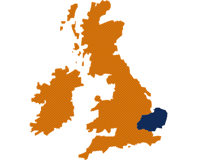
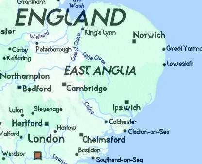
East Anglia is a geographical area in the East of England. The area included has varied but the legally defined NUTS 2 statistical unit, comprises the counties of Norfolk, Suffolk and Cambridgeshire, including the City of Peterborough unitary authority. The name derives from the Anglo-Saxon kingdom of the East Angles, a tribe that originated in Angeln, northern Germany.
Contents
- Environmental sciences university of east anglia uea
- Area
- History
- Geography
- Climate
- Transport
- Universities
- Enterprise zones
- Symbols and culture
- Tourism
- References
Environmental sciences university of east anglia uea
Area
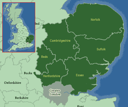
East Anglia is a poorly defined geographical area in the East of England that as a minimum comprises of the counties of Norfolk and Suffolk, and is sometimes said to include parts of Cambridgeshire and Essex. Some sources suggest that the term East Anglia is much like the term Northern England, and it is best described as a cultural region; although in 2016 the East Anglian Devolution Agreement, which proposes cooperation and sharing of resources between several counties, considers the area to have boundaries encompassing Norfolk, Suffolk, Cambridgeshire and the City of Peterborough, which match the boundaries of the Roman Catholic Diocese of East Anglia which was formed in 1976. Essex has sometimes been included in definitions of East Anglia, including by the London Society of East Anglians. However, the Kingdom of Essex to the south, was a separate element of the Heptarchy of Anglo-Saxon England and did not identify as Angles but Saxons. The name derives from the Anglo-Saxon Kingdom of the East Angles, established in the 6th century by a tribe that originated in Angen, northern Germany.
Essex has sometimes been included in definitions of East Anglia, including by the London Society of East Anglians. However, the Kingdom of Essex to the south, was a separate element of the Heptarchy of Anglo-Saxon England and did not identify as Angles but Saxons. The county of Essex by itself forms a NUTS 2 statistical unit in the East of England region.
Other definitions of the area have been used or proposed over the years. For example, the Redcliffe-Maud Report in 1969, which followed the Royal Commission on the Reform of Local Government, recommended the creation of eight provinces in England. The proposed East Anglia province would have included northern Essex, southern Lincolnshire and a small part of Northamptonshire as well as Cambridgeshire, Norfolk and Suffolk.
History
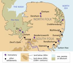
The kingdom of East Anglia initially consisted of Norfolk and Suffolk, but upon the marriage of the East Anglian princess Etheldreda, the Isle of Ely also became part of the kingdom.
The kingdom was formed about the year 520 by the merging of the North and the South Folk (Angles who had settled in the former lands of the Iceni during the previous century) and was one of the seven Anglo-Saxon heptarchy kingdoms (as defined in the 12th century writings of Henry of Huntingdon). For a brief period following a victory over the rival kingdom of Northumbria around the year 616, East Anglia was the most powerful of the Anglo-Saxon kingdoms of England, and its King Raedwald was Bretwalda (overlord of the Anglo-Saxons kingdoms). However, this did not last and over the next forty years East Anglia was defeated by the Mercians twice and continued to weaken in relation to the other kingdoms. Finally, in 794, Offa of Mercia had king Æthelberht killed and took control of the kingdom himself. Although independence was temporarily restored by rebellion in 825, on the 20 November 869 the Danes killed King Edmund and captured the kingdom (see Ivar the Boneless). By 917, after a succession of Danish defeats, East Anglia was incorporated into the Kingdom of England by Edward the Elder, afterwards becoming an earldom.
Despite some engineering work in the form of sea barriers constructed by the Roman Empire, much of East Anglia remained marshland and bogs until the 17th century. From this point onward a series of systematic drainage projects, mainly using drains and river diversions along the lines of Dutch practice, converted the alluvial land into wide swathes of productive arable land. In the 1630s thousands of Puritan families from East Anglia settled in the American region of New England, taking much East Anglian culture with them that can still be traced today. East Anglia, which based much of its earnings on wool, textiles, and arable farming, was a rich area of England until the effects of the Industrial Revolution saw manufacturing and development shift to the Midlands and the North.
During the Second World War, the Royal Air Force and the United States Army Air Forces constructed many airbases in East Anglia for the heavy bomber fleets of the Combined Bomber Offensive against Nazi-occupied Europe. East Anglia was ideally suited to airfield construction as it comprises large areas of open, level terrain and is close to mainland Europe. The reduced flight time to mainland Europe therefore reduced the fuel load required and enabled a larger bomb load to be carried. Building the airfields was a massive civil engineering project and by the end of the war there was one approximately every 8 miles. Many of these airfields can still be seen today, particularly from aerial photographs, and a few remain is use today; the most prominent being Norwich International Airport. Pillboxes, which were erected in 1940 to help defend the nation against invasion, can also be found throughout the area at strategic points.
Geography
East Anglia is bordered to the north and east by the North Sea, to the south by the estuary of the River Thames and shares an undefined land border to the west with the rest of England. Much of northern East Anglia is flat, low-lying and marshy (such as the Fens of Cambridgeshire and Norfolk), although the extensive drainage projects of the past centuries actually make this one of the driest areas in the UK. Inland much of the rest of Suffolk and Norfolk is gently undulating, with glacial moraine ridges providing some areas of steeper areas relief. The supposed flatness of the Norfolk landscape is noted in many famous pieces of literature, such as Noël Coward's Private Lives – "Very flat, Norfolk" and often leads to some confusion when people actually see the relief.
On the north-west corner East Anglia is bordered by a bay known as The Wash, where owing to deposits of sediment and land reclamation, the coastline has altered markedly within historical times; several towns once on the coast of the Wash (notably King's Lynn) are now some distance inland. Conversely, over to the east on the coast exposed to the North Sea the coastline is subject to rapid erosion and has shifted inland significantly since historic times.
Major rivers include Suffolk's Stour, running through country beloved of the painter John Constable, and the River Nene. The River Cam is a tributary of the Great Ouse and gives its name to Cambridge, whilst Norwich sits on the River Yare and River Wensum. The River Orwell flows through Ipswich and has its mouth, along with the River Stour at Felixstowe. The Norfolk and Suffolk Broads form a network of waterways between Norwich and the coast and are popular for recreational boating. The Ouse flows into the Wash at King's Lynn.
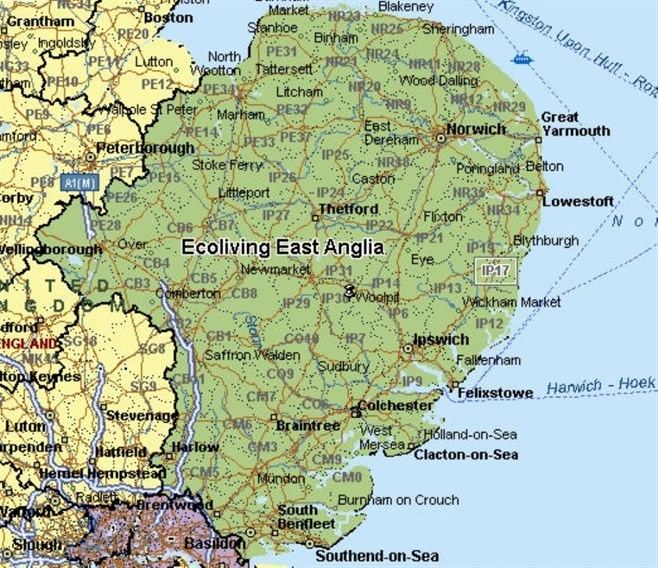
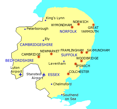
Major urban areas in East Anglia include the cities of Norwich, Cambridge, Peterborough and Ipswich,. Smaller towns and cities include Bury St Edmunds, Ely, Lowestoft, Great Yarmouth and King's Lynn. Much of the area is still rural in nature with many villages surrounded by agricultural land. The landscape of Cambridgeshire and Norfolk has been heavily influenced by Dutch technology, from the use of red clay roof tiles to the draining of The Fens.
Climate
The climate of East Anglia is generally dry and mild. Temperatures range from an average of 1-10 °C in the winter to 12-22 °C in the summer, although it is not uncommon for daily temperatures to fall and rise significantly outside of these averages. Although water plays a significant role in the fenland and broadland landscapes, the area is among the driest in the United Kingdom and during the summer months, tinder-dry conditions are frequently experienced, occasionally resulting in field and heath fires. Many areas receive less than 700mm of rainfall a year and this is fairly evenly distributed throughout the year. Sunshine totals tend to be higher towards the coastal areas.
Transport
Transport in East Anglia consists of an extensive road and rail network. Main A roads, such as the A12 and A47 link the area to the rest of the UK, and the A14 links the Midlands to the Port of Felixstowe. This is the busiest container port in the UK, dealing with over 40% of UK container traffic and a is a major gateway port into the country. There is very little motorway within East Anglia.
Rail links include the Great Eastern Main Line from Norwich to London Liverpool Street and the West Anglia Main Line connecting Cambridge to London. Sections of the East Coast Main Line run through the area and Peterborough is an important interchange on this line. The area is linked to the Midlands and north-west England by rail and has a number of local rail services, such as the Bittern Line from Norwich to Sheringham.
East Anglia is ideal for cycling and National Cycle Route 1 passes through it. Cambridge has the largest proportion of its residents in the UK cycling to work with 25% commuting by bicycle. The city is also home to the Cambridgeshire guided busway, which at 13.3 miles (21.4 km) was the longest stretch of guided bus-way in the world when it opened in 2011.
The only major commercial airport is Norwich International Airport, although London Stansted Airport, the fourth busiest passenger airport in the UK, lies just south of Cambridge in north-west Essex.
Universities
The University of Cambridge, established at the start of the 13th century and situated in the town of the same name, is East Anglia's best-known institution of higher learning, and is among the oldest and most famous universities in the world. Other institutions include the University of East Anglia (in Norwich), Norwich University of the Arts, Anglia Ruskin University (based in Cambridge), University Campus Suffolk (based in Ipswich) and University Centre Peterborough.
Enterprise zones
Great Yarmouth and Lowestoft Enterprise Zone, an enterprise zone initiated by New Anglia Local Enterprise Partnership, was announced in 2011 and launched in April 2012. It includes six sites with a total area of 121 hectares (300 acres), which have attracted a number of energy-related businesses. The sites are Beacon Park and South Denes in Great Yarmouth, Mobbs Way, Riverside Road and South Lowestoft Industrial Estate in Lowestoft and Ellough Business Park in Ellough near Beccles. There is also an enterprise zone in Cambridgeshire, Alconbury Enterprise Campus in Huntingdon.
Symbols and culture
A shield of three golden crowns, placed two above one, on a blue background has been used as a symbol of East Anglia for centuries. The coat of arms was ascribed by medieval heralds to the Anglo-Saxon Kingdom of East Anglia and the Wuffingas dynasty which ruled it. The arms are effectively identical to the coat of arms of Sweden.
The three crowns appear, carved in stone, on the baptismal font (c.1400) in the parish church of Saxmundham, and on the 15th century porch of Woolpit church, both in Suffolk. They also appear in local heraldry and form part of the arms of the diocese of Ely and the arms of the borough of Bury St Edmunds, where the crowns are shown pierced with arrows to represent the martyrdom of Edmund the Martyr, the last king of East Anglia. Other users of the arms include the former Isle of Ely County Council, the Borough of Colchester and the University of East Anglia.
The East Anglian flag as it is known today was proposed by George Henry Langham and adopted in 1902 by the London Society of East Anglians (established in 1896). It superimposes the three crowns in a blue shield on a St George's cross.
East Anglia features heavily in English literature, notably in Noël Coward's Private Lives and the history of its waterways and drainage forms the backdrop to Graham Swift's novel Waterland. The area also figures in works by L.P. Hartley, Arthur Ransome and Dorothy L. Sayers, among many others.
Tourism
East Anglia has a wide range of holiday resorts that range from the traditional coastal towns of Felixstowe and Lowestoft in Suffolk and Great Yarmouth and Hunstanton in Norfolk, to small fishing villages like Aldeburgh and Southwold in Suffolk. Other tourist attractions include historic towns like Bury St Edmunds, Cambridge and Ely as well as areas such as Constable Country, the Broads and the North Norfolk Coast.