
Type Highway | Length 1,062 km | |
 | ||
Route number(s) A39(Goondiwindi-NSW/QLD border) A39(NSW/QLD border-Tocumwal)Duplexes: B56(Coonabarabran-Gilgandra) B64(Marsden-West Wyalong) B94(Mirrool-Ardlethan) North end Leichhardt HighwayGoondiwindi, QueenslandNSW/Qld Border South end Goulburn Valley HighwayTocumwal, New South WalesNSW/Vic Border Major settlements Moree, Narrabri, Coonabarabran, Gilgandra, Dubbo, West Wyalong, Narrandera, Finley | ||
Road trips in australia newell highway
The Newell Highway is a national highway in New South Wales, Australia. The route is currently signed as the A39, however before 2013 was signed as National Highway 39. The Newell Highway is an important road link for freight between Queensland and Victoria and regional centres in western NSW. At 1,058 kilometres (657 mi) in length, the Newell is the longest highway in New South Wales, and passes through fifteen local government areas.
Contents
- Road trips in australia newell highway
- Map of Newell Hwy New South Wales Australia
- Speed limit boosted on newell highway
- Route
- History
- References
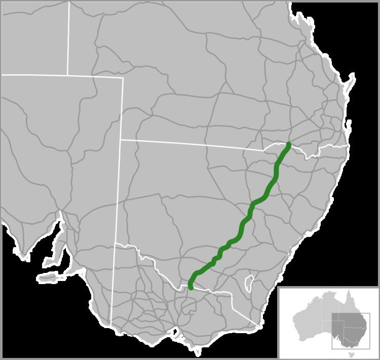
Map of Newell Hwy, New South Wales, Australia
Traffic volumes along the Newell Highway vary significantly from around 1,200 to 4,000 vehicles per day in rural areas. In the urban centres such as Dubbo, average daily traffic volumes are in the order of 20,000 vehicles a day. A large number of heavy vehicles use the Newell Highway – on average, between 26 per cent and 52 per cent of all traffic on the route. At one point in the south west of the state, the highway carries approximately 1,900 vehicle movements daily, of which about 32 per cent are heavy vehicles; while at another point in the north west of the state, believed to be the highest traffic density on that highway, a truck passes every 60 seconds, 24 hours a day 7 days a week.
The Newell Highway carries the National Highway 39 shield for its entire length. The highway is generally flat, with long, straight sections joined by the occasional curved section. However, passing through the Warrumbungle Ranges, there are steeper grades and tighter curves than on the rest of the highway. Open road sections of the Newell Highway are mostly 110 km/h (68 mph) zones. The Newell Highway serves as a major road link between Melbourne and Brisbane; and is named in honour of H. H. Newell, the Commissioner of Main Roads in New South Wales from 1932 until 1941.
Speed limit boosted on newell highway
Route
The highway runs generally north-south, parallel to the eastern coast of New South Wales, about 400 kilometres (250 mi) inland, and is the main inland direct road link from Victoria to Queensland, bypassing the more urbanised and congested coastal areas of the state.
From its northern terminus at Goondawindi in Queensland where it meets the Leichhardt Highway, the Newell runs to the south across the New South Wales and Queensland state border through Boggabilla, Moree, Narrabri, Coonabarabran, Gilgandra, Dubbo, Parkes, Forbes, West Wyalong, Narrandera, Jerilderie, and Finley. The Newell meets its southern terminus at Tocumwal where the highway crosses the Murray River (part of the border between New South Wales and Victoria) and adjoins the Goulburn Valley Highway in Victoria.
The highway crosses eight major inland rivers, from north to south, the Macintyre between Goondiwindi and Boggabilla, the Mehi at Moree, the Namoi near Narrabri, the Castlereagh at Coonabarabran and at Gilgandra, the Macquarie at Dubbo, the Lachlan and Lake Forbes at Forbes, the Murrumbidgee at Narrandera, and the Murray River at Tocumwal. The Newell Highway is subject to periodic flooding north of Moree, at Dubbo, and south of Narrandera.
At various points on its route, the Newell shares part of its route with other highways including, from north to south, the Gwydir at Moree, the Kamilaroi near Narrabri, the Oxley and Castlereagh between Coonabarabran and Gilgandra, the Mitchell at Dubbo, the Mid-Western between Marsden and West Wyalong, and the Riverina near Finley.
History
The Newell was declared a State Highway in 1938, numbered No. 17, and named in honour of H. H. Newell following his death in 1941. At the time of its gazettal, the Newell Highway followed existing roads as far as possible, the exceptions being between Narrandera and West Wyalong and from Coonabarabran to Narrabri completed during 1941-42 and 1946-49 respectively as wartime and post-war defence projects. Between 1965 and November 1992 the Newell Highway carried the National Route 39 black and white shield and despite its misnomer as a national route, the highway was a patchwork of other national and state highways, and funding of the highway was in the main the responsibility of the NSW Government. Following the passage of the Australian Land Transport Development Act 1988 on 15 January 1993 the Australian Government gazetted the Newell as a national highway and assumed funding and administrative responsibility. A large number of non-reflective signs along the highway have reflective NH39 coverplates, a clear indication that they once showed NR39.