
- location west of Coonabarabran - location west of Walgett Mouth Macquarie River | - elevation 630 m (2,067 ft) - elevation 121 m (397 ft) Country Australia | |
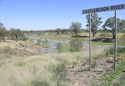 | ||
Castlereagh River, a mostly perennial river that is part of the Macquarie catchment within the Murray–Darling basin, is located in the central–western district of New South Wales, Australia.
Contents
Map of Castlereagh River, New South Wales, Australia
The river rises in the heart of the Warrumbungle mountains and initially flows east through the town of Coonabarabran. It then follows a looping course to the south, west, and finally northwest, joined by 26 minor tributaries, towards its confluence with the Macquarie River; dropping 509 metres (1,670 ft) over its course of 541 kilometres (336 mi). The Castlereagh River has a highly variable flow, and often, low to no flow.
From upstream towards downstream, the Castlereagh River flows through or near the towns of Coonabarabran, Binnaway, Mendooran, Gilgandra and Coonamble.
The Castlereagh River is partly a subterranean river. When there is no water on the surface of the river there is always a stream of water running underground.
European historyEdit
The Castlereagh River was discovered in 1818 by George Evans and explored by John Oxley, who named the river in honour of Lord Castlereagh the same year.
In January 2010, major flooding along the river inundated more than 400 rural properties. Fodder drops were needed and some livestock had to be moved.