
Population 4,368 (2011 census) Postcode(s) 2827 Mean max temp Mean min temp Local time Tuesday 10:49 AM Lga Gilgandra Shire | Established 1888 State electorate(s) Barwon Elevation 282 m Postal code 2827 Federal division Division of Parkes | |
 | ||
Location 460 km (286 mi) from Sydney
66 km (41 mi) from Dubbo Weather 22°C, Wind E at 24 km/h, 72% Humidity | ||
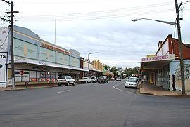
Gilgandra is a town located in the central west region of New South Wales, Australia. The town is located on the junction of the Newell, Oxley and Castlereagh highways and can be reached in about six hours by car from Sydney. The town is the administrative seat for the Gilgandra Shire.
Contents
- Map of Gilgandra NSW 2827 Australia
- History
- Shops and services
- Religion
- Schools
- Attractions
- Notable people
- References
Map of Gilgandra NSW 2827, Australia
Like Coonabarabran, Gilgandra can be considered to be a gateway to the Warrumbungles National Park. At the 2011 census the population of the Gilgandra "statistical area" was 4,368 people. The name Gilgandra is derived from an Aboriginal word meaning "long waterhole" and may be related to fact that town stands on the Castlereagh River.
History
The town was proclaimed in 1888, and the first town blocks were sold in 1889. The area had been previously settled and Gilgandra’s Post Office was established in 1867 and in 1881 a local school opened, and the first court hearing in the Gilgandra court house was in 1884. The shire was constituted in 1906.
During World War I, a recruitment march to Sydney began in Gilgandra. The march was known as the Coo-ee March, after the distinct call of "cooee" they shouted at each town along their journey to attract recruits. Twenty-six men left Gilgandra on 10 October 1915. They were feted at each town on the route and recruitment meetings were held. By the time they reached Sydney just over one month later on 12 November, the numbers had swelled to 263 recruits.
Shops and services
There is a hospital, pharmacy, and medical centres. In 2009, a Supa IGA supermarket was opened. various clothes stores including Target Country and several hotels. Two clubs have bowling greens (bowling club and RSL club) and the golf club has a full sized golf course surrounded by a racecourse.
Religion
Gilgandra has many churches especially for a small town. There is a Catholic, Anglican, United Churches, Lutheran, Jehovah's Witness, Church of Christ, Presbyterian, and a local Indigenous church.
Schools
Gilgandra has 3 schools; Gilgandra High School, (North Gilgandra) (7-12), St. Joseph's School (North Gilgandra) (K-6) and Gilgandra Public School (North Gilgandra) (K-6). The town also has a local pre-school (East Gilgandra), Early Childhood Centre (West Gilgandra) and a TAFE Campus (South Gilgandra). St John's primary (West Gilgandra) was closed in 2004.
Attractions
In the hotter months, the swimming pool is open, and there are skateboard ramps for the youth. There is a youth club, which has squash courts, basketball courts, a gym, and an indoor area.
The tourist information centre is on the south side of town, on the Newell Highway, as entering from Dubbo, on the right hand side after the silos.
There is a Rural Museum, which has old coaches, shearing sheds and equipment, as well as some of the old rooms, decked out as to how they were in the former days. There is Cactus World, which has a large range of cacti.
Gilgandra has an observatory open from Wednesday to Sunday.
There is the community radio station WARFM, which is on 98.9FM, which has a broad range of shows. This is run by local volunteers, and if one feels like they want to present a show, an application will be taken, training given, and probably an available timeslot will be given.
There is also an aero club which serves as a flight school.
Gilgandra has a technical college. There are courses such as business administration, digital photography, and others at times.