
Existed: by 1933 – present | Length 217.8 km | |
 | ||
Counties | ||
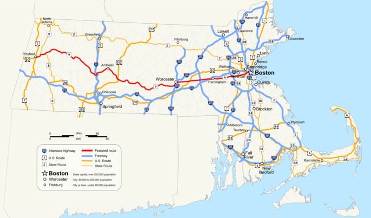
Route 9 is a major east–west state highway in Massachusetts. Along with U.S. Route 20, Route 2, and Interstate 90, Route 9 is one of the major east–west routes of Massachusetts, and like the others its eastern terminus is in Boston. Starting at Copley Square and passing along Huntington Avenue, Route 9 is a limited access route through the MetroWest suburbs to Worcester, and is also a major alternative to the Pike's toll road west of the city. After passing along major city streets in that city, the road becomes a country route, passing through the central Worcester Hills, the Pioneer Valley, and the city of Northampton, and into The Berkshires. The road ends near the center of the city of Pittsfield.
Contents
Map of MA-9, Massachusetts, USA
Route description
Route 9 passes through six counties and twenty-eight cities and towns. It begins in the western Massachusetts city of Pittsfield, at U.S. Route 20. It has a concurrency with U.S. Route 7 during its first mile through the center of that city, then continues east, passing through the towns of Dalton and Windsor, wherein the route reaches its highest point at 2033 ft, in Berkshire County. It continues its winding pass through the small towns of The Berkshires in Berkshire and western Hampshire Counties before passing through the center of Northampton, passing Smith College before its first interstate junction, at Interstate 91. It then crosses the Connecticut River at the Calvin Coolidge Bridge, just downstream from Elwell Island. It goes past the retail area of Hadley before passing the University of Massachusetts Amherst and Amherst College. From Amherst, it winds its way into western Worcester County, south of the Quabbin Reservoir, through small towns until it makes its way into the city of Worcester.
Once in Worcester, Route 9 becomes a major thoroughfare through the city, as Park Avenue, Highland Street (which passes Worcester Center Boulevard), before passing over Interstate 290 and Belmont Street, where University of Massachusetts Medical School and the former Worcester State Hospital are located. From Worcester, it crosses Lake Quinsigamond into Shrewsbury. At this point, Route 9 becomes the main retail artery of the MetroWest region. Several plazas and chain stores are located along the route as it makes its way towards Northborough, where it crosses U.S. Route 20; Westborough, where it crosses Interstate 495; and eventually in the Golden Triangle retail area of Framingham and Natick, after crossing the Massachusetts Turnpike. It passes Shopper's World and the Natick Mall, New England's largest mall.
Beginning in the Golden Triangle, Route 9 becomes one of the major routes into Boston, serving as a valuable bypass to the Mass Pike and its tolls. It crosses Interstate 95 (also known as Massachusetts Route 128) in Wellesley before crossing the Charles River into Newton and Brookline. It enters the city of Boston by crossing over Brookline's former namesake, the Muddy River, part of the Emerald Necklace. at this point it becomes Huntington Avenue, also known as "Avenue of the Arts." It passes the Longwood Medical and Academic Area, which includes Brigham and Women's Hospital, Harvard Medical School and other hospitals; the Museum of Fine Arts; and several colleges and universities, including Northeastern University. This stretch is also a major site of baseball history; the first game of the 1903 World Series, baseball's first true World Series, was played at the Huntington Avenue Grounds, the original home of the Boston Red Sox. (The site is now part of Northeastern's campus.) The "E" Branch of the MBTA Green Line roughly follows Huntington Avenue underground from Copley Square until it rises above ground at the Northeastern Portal. It then operates in a dedicated median of Huntington Avenue between Northeastern University and the Brigham Circle stop, where trains begin street running in mixed traffic to a terminus at Heath Street. Route 9 continues past Symphony Hall and The First Church of Christ, Scientist, which is the mother church of Christian Science. It then passes Copley Place and the Prudential Center complex, before splitting, the eastbound half onto Stuart Street, the westbound onto Saint James Street, past Copley Square; both the eastbound and westbound segments of Route 9 end at Route 28.
History
From Dalton to Goshen in the Berkshires, the road follows the old Berkshire Trail. The massive expansion of the University of Massachusetts Amherst transformed that part of Route 9 in the late 20th century; this otherwise rural part of the route now has several shops, restaurants, and the mid-sized Hampshire Mall. Between Worcester and Boston, Route 9 follows the path of the 19th-century Worcester Turnpike, opened in 1810. This route originally included a floating bridge over Lake Quinsigamond in Shrewsbury. In the 20th century, Route 9 became the focus for urban sprawl in towns like Newton and Wellesley. Further west, in Framingham, Route 9 was home to one of the first modern shopping malls, the aptly named Shoppers' World.
In Natick, Route 9 is officially the "Ted Williams Highway", named after the Red Sox sports legend Ted Williams, who sported that number. In Newton, it is officially the "United Spanish War Veterans Highway".
From 1903 to 1932, the Boston and Worcester Street Railway ran mostly via Route 9. Today the E branch of the MBTA's Green Line follows Route 9 along Huntington Avenue.
Highway improvements
For more information, refer to the Massachusetts Highway Project Listing.