
CT Route 94 → | MA I‑93 → Length 467.3 km | |
 | ||
States: Connecticut, Massachusetts, Vermont | ||
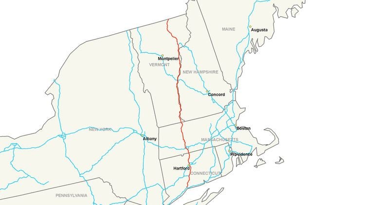
Interstate 91 (I-91) is an Interstate Highway in the New England region of the United States. It provides the primary north–south thoroughfare in the western part of New England. The Interstate's southern end is in New Haven, Connecticut at Interstate 95 and its northern end is at Derby Line, Vermont, a village in the town of Derby, at the Canadian border, where it continues past the Derby Line-Rock Island Border Crossing as Autoroute 55. I-91 is the longest of three Interstate highways whose entire route is located within the New England states (the other two being I-89 and I-93), and is also the only primary (two-digit) Interstate Highway in New England to intersect all five of the others that run through the region. The largest cities along its route are Springfield, Massachusetts, Hartford, Connecticut, and New Haven, Connecticut, in order from north to south.
Contents
- Map of I 91 United States
- Route description
- Connecticut
- Massachusetts
- Vermont
- History
- Route 9 interchange
- Impact on Springfields planned riverfront development
- Exit list
- References
Map of I-91, United States
Route description
I-91 is 290 miles (470 km) long and travels nearly straight north and south: 58 miles (93 km) in Connecticut, 55 miles (89 km) in Massachusetts, and 177 miles (285 km) in Vermont. I-91 parallels U.S. Route 5 (US 5) for all of its length, and many of the exits along I-91 provide direct or indirect access to the older highway. Much of the route of I-91 follows the Connecticut River, traveling from Hartford, Connecticut, northward to St. Johnsbury, Vermont.
Connecticut
I-91 is the major north–south transportation corridor for the center of the state. It is the main route between the larger cities of New Haven, Hartford, and Springfield, Massachusetts. As such, it is almost always heavily trafficked (especially during rush hour), and maintains at least three lanes in each direction through Connecticut except for a short portion in Hartford at the interchange with I-84 and in Meriden at the interchange with Route 15. The three cities also serve as Connecticut's control points along its length of the Interstate. Overhead signs in each direction consistently feature one or two of the cities, although very few (if any) conventional highway mileage signs are placed along the Interstate in Connecticut that indicate the remaining distance between the cities.
I-91 begins just east of downtown New Haven at an interchange with I-95 (the Connecticut Turnpike), and Route 34. At the bottom of the ramp for exit 5, US 5 begins at the first of its many interchanges with the freeway. Leaving New Haven, I-91 follows a northeastward trek into North Haven, where it meets the southern end of the Route 40 expressway. It travels through the eastern part of Wallingford before entering the eastern part of the city of Meriden. In Meriden, about halfway between Hartford and New Haven, I-91 sees a complex set of interchanges with the Wilbur Cross Parkway (Route 15), the Route 66 expressway, and its first spur route, I-691. I-691 provides a westward link to I-84 and the city of Waterbury. Leaving Meriden, I-91 enters Middlesex County as it briefly travels through the western part of Middletown before entering Cromwell, where it has an interchange with the Route 9 expressway.
It then enters Hartford County in the town of Rocky Hill, and then enters Wethersfield, where it meets the southern end of the Route 3 expressway, which leads to Glastonbury and the Route 2 expressway via the Putnam Bridge over the Connecticut River. From here to St. Johnsbury, Vermont, I-91 parallels the river, never more than five miles (8.0 km) from its shore. I-91 then enters the Hartford city limits. In Hartford, I-91 it has a set of interchanges with US 5/Route 15 (Wilbur Cross Highway), which provides access from I-91 north to I-84 east, and from I-84 west to I-91 south via the Charter Oak Bridge. I-91 then has an interchange with I-84, where all other movements to and from I-84 take place. Before leaving the city limits, an HOV lane begins that has its own set of interchanges up to exit 38.
I-91 then enters Windsor, where it meets the western end of its other Connecticut spur route, I-291. At the Windsor–Windsor Locks town line, it meets the eastern terminus of the Route 20 expressway, which provides direct access to Bradley International Airport. A couple miles north, I-91 crosses the Connecticut River on the Dexter Coffin Bridge into East Windsor. After traveling through East Windsor and Enfield, it crosses the Massachusetts state line into Longmeadow at milepost 58.
Massachusetts
I-91 travels 55 miles (89 km) through the Pioneer Valley of western Massachusetts paralleling the Connecticut River. I-91 serves as the major transportation corridor through three Massachusetts counties, linking the cities of Springfield, Northampton, and Greenfield. The three cities serve as the control cities listed on guide and mileage signs, along with Brattleboro, Vermont beginning with the first northbound conventional mileage sign (63 miles (101 km)) in Longmeadow.
In Springfield, I-91 has an interchange with I-291 at exit 8, a 5.44-mile-long (8.75 km) spur going eastbound connecting with the Massachusetts Turnpike, for travelers going either east to Boston or west to Albany, New York.
North of Springfield, I-91 briefly enters Chicopee itself where there is an interchange with the spur of I-391 at exit 12 before turning westward to cross the Connecticut River into West Springfield. I-391 provides direct access to Holyoke center, while I-91 continues on the western side of the river.
Just after the river crossing, exit 14 is a major interchange with the Massachusetts Turnpike (I-90) before entering the city of Holyoke where exit 15 is located. Just after exit 16 U.S. Route 202, I-91 goes from three lanes to two lanes in each direction to the Vermont state line.
After a short exit-less stretch, I-91 enters Northampton, passing the Northampton Airport and an oxbow lake. The towns of Hadley and Amherst, home to the main campus of the University of Massachusetts Amherst, are accessible from I-91 exits in Northampton via Route 9.
Continuing north, I-91 enters Hatfield, and where it begins its straightest section—nearly six miles (9.7 km) without a bend in the road. Several exits provide access to US 5 and Route 10 in Hatfield and Whately before entering Deerfield.
I-91 has two exits in Greenfield. At exit 26, there is a rest area/visitor information center for Franklin County. Exit 28 in Bernardston is the last exit in Massachusetts. Beyond exit 28, I-91 continues for about five miles (8.0 km) more before crossing into Vermont.
The 55-mile (89 km) stretch of I-91 in Massachusetts was the last section that featured motorist-aid call boxes. The call boxes were important as a good part of I-91 in Massachusetts is rural, unlike many other freeways in the state. The call boxes were eventually removed in 2012. Massachusetts is the only state traversed by I-91 where another numbered highway is concurrent with the Interstate (in this case, US 5, for a one-half mile (800 m) spur near the Springfield-Longmeadow town line and Route 2, for approximately three miles (4.8 km) in Greenfield).
Vermont
I-91 travels along the eastern border of Vermont and serves as a major transportation corridor for eastern Vermont and western New Hampshire. Many exits along Vermont's length of I-91 feature New Hampshire towns on the guide signs (for example, exit 3, which lists Brattleboro and Keene, as the points of access). The length of I-91 within Vermont is 177 miles (285 km), and has two lanes in each direction the entire way from the Massachusetts state line at Guilford to Derby Line at the Canadian border (nearly two-thirds of I-91's length) with 29 Vermont interchanges. The highway's rural character and long distances between exits in Vermont are in stark contrast to its south, where exits are more frequent and the road carries four lanes of traffic in each direction at some points. The major control cities in Vermont are Brattleboro, White River Junction, St. Johnsbury, and Newport. When re-entering northbound I-91 at exit 28 in Derby, the control city sign is for Canada. Of these destinations, only Newport is a city, although the other towns are sizable. In general, the road parallels its predecessor, US 5.
I-91 enters Vermont in the town of Guilford. Just before exit 1 in Brattleboro is the Vermont Welcome Center in Guilford. The first three Vermont exits (northbound) serve the town of Brattleboro. At exit 1, northbound Route 5 provides access to stores and a small industrial area before reaching the south end of the town's center, where a bridge crosses the Connecticut River into Hinsdale, New Hampshire via NH 119. Exit 2/VT 9 provides access to the western village of the town (West Brattleboro), then continues west to Marlboro, Wilmington, and Bennington. Brattleboro's main retail strip is located at and just south of the exit 3 trumpet interchange and traffic circle. Following VT 9 eastward, one can reach Keene, New Hampshire in 15 miles (24 km).
After exit 3, I-91 heads north to travel through the towns of Dummerston, Putney, Westminster, Rockingham, Springfield, Weathersfield, Windsor, Hartland, and Hartford, home of the village of White River Junction. White River Junction, listed as a control city on mileage signs as far south as Greenfield, Massachusetts, is where I-91 and I-89 meet and provide access to many points in Vermont and New Hampshire, at exit 10.
North of the interchange with I-89, I-91 continues towards St. Johnsbury and travels through the towns of Norwich, Thetford, Fairlee, Bradford, Newbury (with access to the village of Wells River), and Barnet, before coming to its next major intersection. Towns in New Hampshire on the other side of the river can also be easily accessed in this stretch. At exit 19 is the northern terminus of I-93, a major interstate highway in New England, which provides a direct route south through the White Mountains and to almost all major cities in New Hampshire. Just after exit 19, there are three exits for St. Johnsbury, including a major intersection with US 2. Along westbound US 2, the capital of Vermont, Montpelier, is eventually reached from I-91, although I-89 provides Montpelier with immediate Interstate access.
I-91 continues northward, now following the Passumpsic River valley. It travels through Vermont's Northeast Kingdom region and the town of Lyndon. Two exits in Lyndon serve the village of Lyndonville and Lyndon State College. After exit 24, I-91 departs Route 5, which it had been closely paralleling since the Massachusetts state line. I-91 follows the valley of Miller Run, and there are no convenient services until Barton at exit 25.
The interstate proceeds through Sheffield. Here it reaches the highest point on the road, just north of mile marker 150 on Sheffield Heights, elevation 1,856 feet (566 m).
After leaving the Heights, it enters Orleans County and follows the Barton River valley north with exits in Barton, Orleans, and Derby. Exit 29 is the final U.S. exit on I-91 just after mile marker 177 at Derby Line. Beyond the exit ramp, northbound motorists enter Canada Customs at Stanstead, Quebec and continue into Canada on Autoroute 55 through the Eastern Townships.
As with Connecticut and Massachusetts, US 5 closely parallels I-91 for their entire lengths in Vermont. Indeed, most of the large exit signs on I-91 list US 5 as one of the roads (if not the only road) that can be accessed from the exit, as seen in the exit list below. While paralleling I-91 in Vermont, US 5 is never concurrent with the freeway, but remains its own two-lane road, except for a portion in White River Junction where it is a four-lane divided surface arterial.
Traffic and the population of each successive town tend to diminish as the road proceeds northward. Average daily traffic count for 2002 were—Brattleboro (25,600), White River Junction (28,900), St. Johnsbury (10,800), and Derby Line (2,500).
History
A limited-access highway replacement for U.S. Route 5 was planned at the federal level starting in 1944. A 1953 Massachusetts plan was funded by the Federal Aid Highway Act of 1956, along with spur Interstate 291 (but not Interstate 391). The Vermont section of I-91 was built in stages from 1958 to 1965. In Massachusetts from Bernardston to Northampton, I-91 follows an abandoned right-of-way of the New York, New Haven and Hartford Railroad. To support plans for urban renewal along the "low value" waterfront, the highway crossed the Connecticut River to parallel active NYNHH railroad tracks on the Springfield side of the river, bypassing West Springfield, Massachusetts and Agawam, Massachusetts. Later, this path was perceived as cutting off the city from the river, restricting further commercial development. By 1960, a few miles in Massachusetts were completed, starting from the Connecticut and Vermont state lines. Massachusetts construction was completed from 1964 to 1970.
In the 1970s there were plans to extend I-91 along the Long Island Sound link across from New Haven, Connecticut, to Long Island in New York. The extension would have continued southward to the southern shore of the island perhaps along the route of the current William Floyd Parkway in central Suffolk County. It would also provide easier access to New York City via the Long Island Expressway, as well as to The Hamptons via Sunrise Highway (New York State Route 27). The various proposals for a bridge were dropped after a 1979 study of the concept.
Vermont completed its last sections of I-91 in 1978.
After the September 11 attacks, there has been a seldom-manned temporary border patrol checkpoint near White River Junction, VT that is about 100 miles (160 km) from the Canadian border.
Starting in the 1990s, several rest areas were downgraded in Vermont, increasing distances between facilities. In 2008, Vermont closed the Springfield-Rockingham rest areas because of suspected use by drug abusers. In 2009, the northbound rest area in Hartford was closed, creating a 90-mile (145 km) gap in on-highway facilities. At the present time, there exist 2 intermediate rest areas with facilities in each direction, in addition to a welcome center at each end of the state. Several parking areas remain open.
In 2005, the Massachusetts Highway Department completed a rebuild of on- and off-ramps in Springfield, to reduce accidents caused by weaving near the tightly spaced exits.
In the early 1990s after the Interstate 284 project was canceled, The Exit 44 interchange in East Windsor, Connecticut was altered as it was designed to be part of the freeway. After alters, Exit 44 connected to Route 5 for all traffic to get on and off. As a result, Exit 43 was shut down and closed in that same time frame. Exit 43 was a northbound exit/southbound entrance on State Route 510/Main Street in East Windsor, which was about 2/10ths of a mile away from exit 44.
Route 9 interchange
A major rebuild of the interchange with Route 9 in Northampton is in the planning phases, as of September 2015.
Impact on Springfield's planned riverfront development
In 2008, Springfield's urban planners contracted UMass Amherst's School of Urban Design to research I-91's effects on Springfield, after receiving complaints from Springfielders about I-91's inhibiting residents' access to Springfield's riverfront, and access to the Basketball Hall of Fame. By 2011, Amherst had produced several dozen critiques denoting that I-91's current route, height, and development beneath and around the highway are inhibiting the development of the city's greatest potential economic and recreational resources, the Connecticut River, the riverfront, and the Basketball Hall of Fame—and also limiting the interaction between these entities and the Metro Center.
During its construction in the 1960s, Interstate 91 sliced through three Springfield neighborhoods: the North End, Metro Center, and the South End. Widely regarded as positive progress at the time, by 2011, Springfield's portion of I-91 was perceived as disrupting the urban fabric of each riverfront neighborhood, while in effect amputating everything east of the highway—the majority of the city—from the Connecticut River, the Connecticut River Walk Park, and the Basketball Hall of Fame. However, Interstate 91 was erected without tunnels, footbridges, and other paths leading to the riverfront, and thus continues to pose logistical problems for people getting to the riverfront, which in turn poses problems for businesses that would like to set up along Springfield's riverfront. The placement of I-91 has left Springfield's riverfront virtually undeveloped aside from the sliver of land surrounding the Basketball Hall of Fame, an international tourist destination, which, under different circumstances, might have more commercial and residential development.
As of 2011, academic and civic studies are still underway. Preliminary findings indicate that I-91's placement negatively impacts tourism in Springfield's Metro Center—the site of many of Springfield's historic, cultural, and entertainment venues. Springfield's most popular tourist attraction, the riverfront Basketball Hall of Fame, is separated from Metro Center by a 20 feet (6.1 m) stone wall, buttressing an elevated portion of the 6-lane Interstate 91, and greatly discouraging travel between the two areas.
Initially, in the 1950s and early 1960s, Interstate 91 was planned to be routed through West Springfield, Massachusetts, down the avenue now known as Riverdale Road—with numerous bridges to be built to accommodate traffic into the City of Springfield. Indeed, Riverdale Road is the original four-lane highway built to accommodate the traffic of Interstate 91. (I-91 has since widened to six lanes.) In the 1960s, after Springfield learned that its longtime rival, and current business partner in the Knowledge Corridor initiative, the City of Hartford, would use its riverfront to host Interstate 91, Springfield civic leaders petitioned for the I-91 highway to be moved to the east side of the river to cut through the city, rather than employ a series of bridges, as was originally planned. At that time of initial construction, the Connecticut River was polluted and, to many, it seemed that its best days were long behind it. Construction plans were hastily drawn up and executed, and thus construction began on the I-91 highway. On its completion, although its daily usage far surpassed predictions, I-91 never catalyzed significant growth in Springfield, as was the original hope.
Academic suggestions that involve the demolition of the current highway and moving it to a less obtrusive site in the city have been proposed, including the demolition of the highway and following the original path suggested, Riverdale Road, and, least obtrusive but still requiring a great deal of work, a plan to construct numerous walkways beneath the elevated highway to better integrate the neighborhoods with the waterfront despite the highway's presence.
In 2010, the Urban Land Institute made recommendations for how Springfield might reconnect with its riverfront, suggesting the most cost-effective but also the most development-limiting strategy (constructing pathways beneath I-91). No decision has been reached regarding those recommendations.
Exit list
All interchanges in Massachusetts were to be renumbered to milepost-based numbers under a project scheduled to start in 2016. However, this project has now been indefinitely postponed.