
Founded April 24, 1761 Area 2,450 km² | Population 129,585 (2013) | |
 | ||
Points of interest The Berkshires, Norman Rockwell Museum, Massachusetts Museum of Contemp, Sterling and Francine, The Mount Colleges and Universities Williams College, Berkshire Community College, Massachusetts College of Liberal Arts, Bard College at Simon's, Charles H McCann Technical | ||
Berkshire County, pronounced /bərkʃər/, is a county located on the western edge of the U.S. state of Massachusetts. As of the 2010 census, the population was 131,219. Its largest city and traditional county seat is Pittsfield. The county was founded in 1761.
Contents
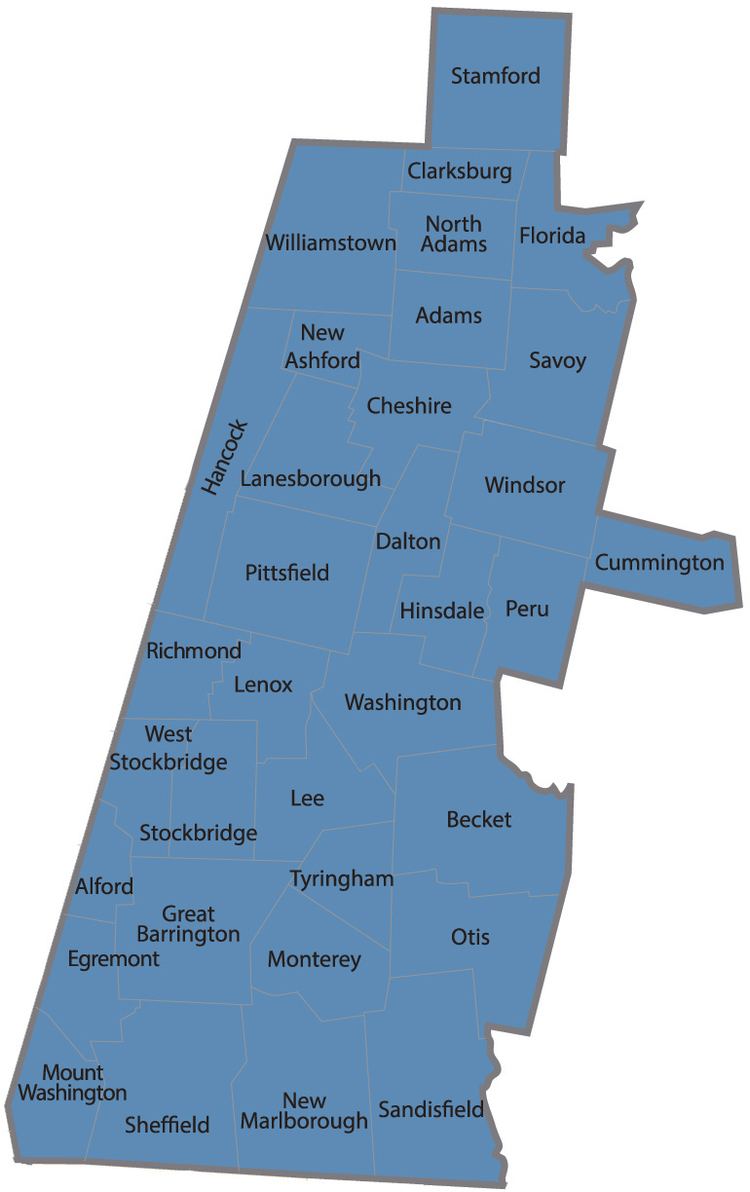
- Map of Berkshire County MA USA
- Law and government
- Geography
- 2000 census
- 2010 census
- Income
- Politics
- History
- Cities
- Villages
- Transportation
- Notable residents
- References
Map of Berkshire County, MA, USA
The Berkshire Hills are centered on Berkshire County, and the county itself is often referred to simply as the Berkshires. It exists today only as a historical geographic region, and has no county government.
Law and government
Of the fourteen Massachusetts counties, Berkshire County is one of eight that exists today only as a historical geographic region, and has no county government. Berkshire County government was abolished effective July 1, 2000, and all former county functions were assumed by state agencies, and there is no county council or commission. The sheriff became a Commonwealth employee, but remains locally elected to perform duties within the county region and retains administrative and operational control over the Berkshire Sheriff’s Office, an independent state agency that was created after the county government was abolished. The Berkshire Sheriff’s Office runs the county jail and house of correction.
Local communities were granted the right to form their own regional compacts for sharing services, and the towns of Berkshire County have formed such a regional compact known as the Berkshire Regional Planning Commission.
Berkshire County has three Registry of Deeds Districts, one for each district.
Berkshire County is located in the Massachusetts's 1st congressional district, a primarily rural district that makes up most of Western Massachusetts.
Berkshire County has four (4) districts and elected Representatives in the Massachusetts House of Representatives.
Berkshire County is located in one (1) district for the Massachusetts Senate.
The district consist of all of Berkshire County and the following cities: Chesterfield, Cummington, Goshen, Huntington, Middlefield, Plainfield, Westhampton, Williamsburg and Worthington, in the county of Hampshire; and Ashfield, Charlemont, Conway, Hawley, Heath, Monroe and Rowe, in the county of Franklin. Benjamin B. Downing (D), is the current Senator.
The Massachusetts Governor's Council, also known as the Executive Council, is composed of eight individuals elected from districts, and the Lt. Governor who serves ex officio. The eight councillors are elected from their respective districts every two years. Berkshire County is located in the 8th District.
The Council generally meets at noon on Wednesdays in its State House Chamber, next to the Governor's Office, to act on such issues as payments from the state treasury, criminal pardons and commutations, and approval of gubernatorial appointments; such as judges, notaries and justices of the peace.
See also the League of Women Voters of Massachusetts page on counties.
Geography
According to the U.S. Census Bureau, the county has a total area of 946 square miles (2,450 km2), of which 927 square miles (2,400 km2) is land and 20 square miles (52 km2) (2.1%) is water. It is the second-largest county in Massachusetts by land area. The highest natural point in Massachusetts, Mount Greylock at 3,492 feet (1,064 m) is located in Berkshire County.
Berkshire County is one of two Massachusetts counties that borders three different neighboring states; the other being Worcester County. The two counties are also the only ones to touch both the northern and southern state lines.
Running north-south through the county are the Hoosac Range of the Berkshire Hills in the eastern part of the county and the Taconic Mountains in the western part of the county. They are a source of pride for their beauty, and have marked the county's character. Due to their elevation, the Berkshires attract tourists and summer residents eager to escape the heat of the lowlands.
2000 census
As of the census of 2000, there were 134,953 people, 56,006 households, and 35,115 families residing in the county. The population density was 145 people per square mile (56/km²). There were 66,301 housing units at an average density of 71 per square mile (27/km²). The racial makeup of the county was 95.02% White, 1.99% Black or African American, 0.15% Native American, 0.99% Asian, 0.04% Pacific Islander, 0.59% from other races, and 1.23% from two or more races. 1.69% of the population were Hispanic or Latino of any race. 16.5% were of Italian, 16.4% Irish, 10.8% French, 10.3% English, 8.0% Polish, 7.1% German, 5.8% American and 5.1% French Canadian ancestry according to Census 2000. 94.1% spoke English, 1.6% Spanish and 1.1% French as their first language.
There were 56,006 households out of which 27.50% had children under the age of 18 living with them, 48.00% were married couples living together, 11.00% had a female householder with no husband present, and 37.30% were non-families. 31.60% of all households were made up of individuals and 13.90% had someone living alone who was 65 years of age or older. The average household size was 2.30 and the average family size was 2.89.
In the county, the population was spread out with 22.40% under the age of 18, 8.40% from 18 to 24, 26.40% from 25 to 44, 24.90% from 45 to 64, and 17.90% who were 65 years of age or older. The median age was 40 years. For every 100 females there were 91.70 males. For every 100 females age 18 and over, there were 88.10 males.
The median income for a household in the county was $39,047, and the median income for a family was $50,162. Males had a median income of $36,692 versus $26,504 for females. The per capita income for the county was $21,807. About 6.50% of families and 9.50% of the population were below the poverty line, including 12.30% of those under age 18 and 7.20% of those age 65 or over.
2010 census
As of the 2010 United States Census, there were 131,219 people, 56,091 households, and 33,618 families residing in the county. The population density was 141.6 inhabitants per square mile (54.7/km2). There were 68,508 housing units at an average density of 73.9 per square mile (28.5/km2). The racial makeup of the county was 92.5% white, 2.7% black or African American, 1.2% Asian, 0.2% American Indian, 1.2% from other races, and 2.1% from two or more races. Those of Hispanic or Latino origin made up 3.5% of the population. In terms of ancestry, 23.5% were Irish, 16.9% were Italian, 14.3% were English, 12.1% were German, 9.6% were Polish, and 3.0% were American.
Of the 56,091 households, 25.9% had children under the age of 18 living with them, 43.9% were married couples living together, 11.5% had a female householder with no husband present, 40.1% were non-families, and 33.0% of all households were made up of individuals. The average household size was 2.23 and the average family size was 2.82. The median age was 44.7 years.
The median income for a household in the county was $48,907 and the median income for a family was $64,783. Males had a median income of $47,401 versus $35,964 for females. The per capita income for the county was $28,300. About 7.9% of families and 11.6% of the population were below the poverty line, including 15.5% of those under age 18 and 7.3% of those age 65 or over.
Income
The ranking of unincorporated communities that are included on the list are reflective if the census designated locations and villages were included as cities or towns. Data is from the 2007-2011 American Community Survey 5-Year Estimates.
Politics
In the last two U.S. Presidential elections, Berkshire County was Massachusetts's second-bluest county behind Suffolk County, which consists primarily of Boston. In 2004, the Bay State's native son John Kerry carried Berkshire by a massive 47.4% margin over incumbent President George W. Bush, with Kerry winning his home state by 25.2% over President Bush. In 2008, the county voted for Barack Obama by a 52.4% margin over John McCain, with Obama winning by 25.8% over McCain statewide. Obama won the county by an even larger margin of 53.6% in the 2012 election.
History
The Mahican (Muh-he-ka-neew) Native American tribe lived in the area that now makes up Berkshire County until the early 18th century, when the first English settlers and frontiersmen appeared and began setting up farms and homesteads. On April 25, 1724, “The English finally paid the Indians 460 pounds, 3 barrels of cider, and 30 quarts of rum for what is today Berkshire County.” This deal did not include modern Sheffield, Stockbridge, Richmond, and Lenox, which were added later. Berkshire County remained part of Hampshire County until 1760.
In the 19th century, Berkshire County became popular with the American elite, which built what they called "cottages" throughout the countryside. The Gilded Age ended in the early 20th century with the income tax, World War I, and the Great Depression. In the 20th, century some of these cottages were torn or burned down, while others became prep schools, historic sites, or bed-and-breakfast inns.
Today Berkshire is known throughout the East Coast and the country as the summer home of the Boston Symphony Orchestra. It includes attractions such as Tanglewood, the Norman Rockwell Museum, Mass MOCA, and Hancock Shaker Village.
Cities
Villages
Villages and census-designated places are unincorporated communities that have no separate legal existence from the towns they are in.
Transportation
County-wide bus service is provided by the Berkshire Regional Transit Authority. Amtrak service is provided at Pittsfield.