
Maintained by: Caltrans | ||
 | ||
Similar Cypress Street Viaduct, Caldecott Tunnel, Temescal Creek, MacArthur station, Sausal Creek | ||
Amazing the rebuilding the macarthur maze documentary
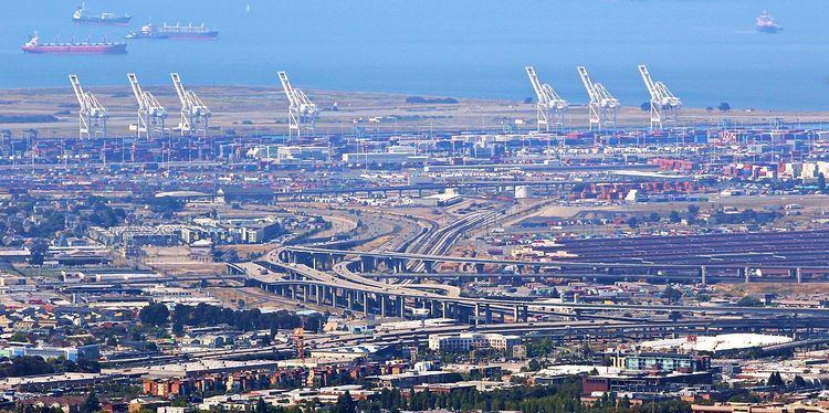
The MacArthur Maze (or simply the Maze, also called the Distribution Structure) is a large freeway interchange near the east end of the San Francisco–Oakland Bay Bridge in Oakland, California. It splits Bay Bridge traffic into three freeways—the Eastshore (I-80/I-580), MacArthur (I-580) and Nimitz (I-880).
Contents
- Amazing the rebuilding the macarthur maze documentary
- Description
- History
- 1989 Loma Prieta earthquake
- 2007 I 580 East Connector collapse
- Rebuilding
- References
Description
San Francisco Bay Area traffic funnels across the few bridges spanning the bay, so the Maze's central location near the east end of the San Francisco–Oakland Bay Bridge makes it a hub for east–west and north–south traffic accessing San Francisco. It is also next to the Port of Oakland, the fourth busiest container port in the United States.
The four freeways intersecting at this interchange are:
Local traffic using the interchange includes East Bay commuters to and from San Francisco via the Bay Bridge, as well as drivers traveling up and down the East Bay. For long distance traffic accessing other parts of the country, I-80 is the primary Interstate Highway for points east. Although Interstate 5, the main north–south Interstate Highway on the West Coast of the United States, bypasses the Bay Area to the east, connections are provided to the Maze via I-505 and I-80 from the north, and I-580 to the south. Furthermore, drivers on US 101 who want to bypass San Francisco can use I-880 from San Jose to the Maze, and then I-580 across the Richmond-San Rafael Bridge.
History
The Maze started as part of the construction of the Bay Bridge in the 1930s. It was named the "Distribution Structure" but eventually became the "Maze" to the media and public. The first maze was simple: westbound traffic from 38th St (later MacArthur Blvd) merged with northbound traffic from Cypress St and crossed above the Southern Pacific tracks, then split into ramps north to the Eastshore Highway (US 40) and west to the Bay Bridge. A parallel set of ramps handled eastward/southward traffic. Aerial view looking SE Traffic flows thus had only a few hundred feet to weave through each other until about 1955 when the Maze was enlarged to prepare for the four freeways that converged there a few years later. Another round of extensive re-engineering followed the 1989 Loma Prieta earthquake, including the addition of diamond lane ramps and a huge girder flyover connecting the relocated northbound Nimitz with the northbound Eastshore Freeway (which is technically I-80 eastbound and I-580 westbound). The original 1936 ramps were removed during this 1990s construction.
The nickname "MacArthur" Maze originated sometime after the construction of the MacArthur Freeway in the late 1950s, named after MacArthur Boulevard, the original US Route 50 through Oakland that the freeway bypassed, which is named for General Douglas MacArthur.
Film footage of the early Maze can be seen in the 1941 movie Shadow of the Thin Man, as Nick and Nora Charles drive off the Bay Bridge on their way to Golden Gate Fields in Albany.
1989 Loma Prieta earthquake
During the 6.9 Mw Loma Prieta earthquake, the double-decked Cypress Street Viaduct on I-880 between I-80 and the 14th Street exit collapsed, crushing cars and killing 42 people. Traffic on the MacArthur Maze headed towards I-880 was re-routed to I-580 and I-980, and ramps at both ends of the viaduct leading to the former Cypress Structure were signed for local traffic access to Cypress Street.
The Cypress Street Viaduct was demolished soon after the earthquake, but a replacement freeway wasn't finished until July 1997, due to lawsuits by environmentalists and local residents. The final connection to the Maze, known as the East Bay Viaduct, opened in 1998 (though a connection northwest to the Bay Bridge along the alignment of the old Grand Avenue Viaduct was built in 1995). The replacement sections of the Nimitz Freeway dispensed with the double-deck design. It was built near the Union Pacific railway tracks around the outskirts of West Oakland, rather than bisecting that neighborhood as the Cypress Viaduct had. Cypress Street, which ran on each side of the old double-deck highway, is now a landscaped parkway and has been renamed Mandela Parkway. In 2007 Mandela Parkway was linked at its north end with the west end of Yerba Buena Avenue, creating a route into Emeryville.
2007 I-580 East Connector collapse
At 3:42 am on Sunday, April 29, 2007, a tank truck carrying 8,600 gallons (32,500 liters) of unleaded gasoline overturned on the connector from Interstate 80 west (from Berkeley) to Interstate 880 south.Wikimapia The intense heat from the subsequent fuel spill and fire weakened the steel structure of the roadway above, which served as the connecting ramp from Interstate 80 east (from San Francisco) to Interstate 580 east (to Oakland), collapsing approximately 168 feet (50 m) of it onto the lower connector. The truck driver involved suffered second degree burns on his hands but was nonetheless able to walk 1.5 miles (2.4 km) to a gas station, where he found a taxi and was given a ride to Oakland Kaiser Medical Center. No other vehicles or persons were reported to be involved in the accident.
The California Highway Patrol (CHP) initially reported that they suspected that the tanker had been speeding and bounced off a guard rail, leading to the overturn. The driver was found to have a clean record the preceding decade; drug or alcohol use was determined not to be a factor in the accident.
The collapse of this bridge cut off the return route from San Francisco for many East Bay commuters (primarily those whose destinations are Walnut Creek and southeastern Oakland). To help ease the expected traffic snarl, Caltrans set up temporary detours within the days following the incident, Bay Area Rapid Transit (BART) added additional capacity to lines serving areas that had been impacted by the incident, and on Monday April 30, all public transportation in the Bay Area was free, with the estimated cost of $2.5 million paid out of state funds. News commentators have pointed out the similarities to the disruption caused by the Loma Prieta earthquake 18 years earlier. While there was some serious congestion on the detour routes, the expected traffic jams and long delays did not fully materialize. This was possibly due to commuters switching to alternate transit options, indicated by BART posting record ridership numbers during that time.
Rebuilding
Caltrans spokespersons estimated immediately after the accident that it would take weeks to clear the debris from the scene and months to rebuild the affected sections. Initial cost projections for rebuilding the I-580 connector alone reached $10 million. However, due to the urgency to reopen such a vital highway link the project was expedited, and most demolition work and debris removal was completed by the Tuesday following the accident. For a historic comparison, Caltrans did successfully replace a single damaged upper deck panel of the Bay Bridge (after the Loma Prieta earthquake) and the collapsed portion of the I-10 Santa Monica Freeway in Los Angeles (after the Northridge earthquake) in roughly one month by expediting its internal approval process and offering an incentive program for the contractors.
On May 7, 2007, the I-880 connector reopened at 4:30 am to traffic. Substantial work was done to retrofit the strength of the structure, which had sunk 9 inches (230 mm) due to the collapse of the I-580 connector onto the I-880 connector.
A contractor with a proven track record of rebuilding damaged freeways (most notably the Santa Monica Freeway after the 1994 Northridge earthquake) well ahead of schedule, C. C. Myers, Inc., submitted a winning bid of $876,075 to repair the damage to the I-580 connector. The bid was estimated to cover only one-third of the cost of the work, but the firm counted on making up the shortfall with an incentive of $200,000 per day if the work was completed before June 27, 2007.
On the evening of Thursday, May 24, the I-580 connector re-opened, just before the busy Memorial Day weekend. The deadline to finish the project was beaten by over a month, with the contractor earning the $5 million bonus for early completion. The entire reconstruction project was completed only 26 days after the original accident.
A state projection concluded that the connector collapse had cost $90 million, based on a $6 million per day economic impact estimate. This includes a $491,000 loss in toll revenue for the Oakland Bay Bridge.
On May 25, 2007, the CHP revoked the license for transporting hazardous materials from Sabek Transportation, the owner of the tank truck, after an investigation found 36 violations of its operations and equipment.