
County Alameda ZIP codes 94546, 94552 Elevation 49 m Area code Area code 510 | State California Time zone PST (UTC-8) FIPS code 06-11964 Area 43.82 km² Population 61,388 (1 Apr 2010) | |
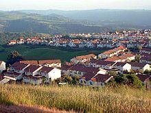 | ||
Castro Valley is a census-designated place (CDP) in Alameda County, California, United States. As of the 2000 census, it is the fifth most populous unincorporated area in California and the twenty-third most populous in the United States. The population was 61,388 at the 2010 census.
Contents
- Map of Castro Valley CA USA
- History
- Geography
- 2010
- 2000
- Economy
- Art and culture
- First public school in Castro Valley
- Adobe Art Gallery
- Law and government
- Education
- Public schools
- Private schools
- Transportation
- Services
- References
Map of Castro Valley, CA, USA
Castro Valley is named after Don Guillermo Castro, who was a soldier in the Mexican army and a rancher.
First known for chicken ranches, Castro Valley eventually became a bedroom community.
History
Before the arrival of European settlers the area was settled by the Chocheño (also spelled Chochenyo or Chocenyo) subdivision of the Ohlone Native Americans.
With the arrival of Europeans, Castro Valley was part of the land granted to Mission San Jose in 1797. The area Castro Valley now occupies was part of the extensive colony of New Spain in what was the state of Alta California.
Castro Valley was part of the original 28,000 acre (110 km²) land grant given to Castro, called Rancho San Lorenzo. This land grant included Hayward, San Lorenzo, and Castro Valley, including Crow Canyon, Cull Canyon, and Palomares Canyons. Castro had a gambling habit and had to sell off portions of his land to pay gambling debts. The last of his holding was sold in a sheriff's sale in 1864 to Faxon Atherton for $400,000.
Atherton (after whom the city of Atherton is named) in turn began selling off his portion in smaller parcels. Two gentlemen named Cull (the namesake of Cull Canyon) and Luce bought some 2,400 acres (10 km²) and began running a steam-operated saw mill in Redwood Canyon. The Jensen brothers also bought land from Atherton in 1867.
During the 1940s and 1950s, Castro Valley was known for its chicken ranches. Later it developed into a bedroom community, where workers live and commute to their jobs in the surrounding communities.
Geography
Lake Chabot lies at the north of Castro Valley. Directly to the west is San Leandro. Hayward is to the south. To the east, the closest cities are San Ramon, Dublin, and Pleasanton. The San Leandro Hills extend along the northeastern edge of the community.
The eastern hills of Castro Valley constitute the headwaters of the San Lorenzo Creek watershed and the origin of several creeks that flow into San Lorenzo Creek: Bolinas, Castro Valley, Chabot, Crow, Cull, Eden, Hollis, Kelly Canyon, Norris, and Palomares Creeks.
2010
The 2010 United States Census reported that 61,388 people, 22,348 households, and 16,112 families resided in the CDP. The population density was 3,690.3 people per square mile (1,424.8/km²). There were 23,392 housing units at an average density of 1,382.6 per square mile (533.8/km²). The racial makeup of the CDP was 58.0% White (49.5% non-Hispanic), 6.9% African American (6.6% non-Hispanic), 0.5% Native American, 21.4% Asian, 0.7% Pacific Islander, 6.1% from other races, and 6.3% from two or more races. 17.4% of the population was Hispanic or Latino of any race.
The Census reported that 98.0% of the population lived in households, 0.4% lived in non-institutionalized group quarters, and 1.5% were institutionalized.
There were 22,348 households out of which 36.1% had children under the age of 18 living in them, 54.3% were opposite-sex married couples living together, 12.6% had a female householder with no husband present, and 5.2% had a male householder with no wife present. 5.0% of households were unmarried opposite-sex partnerships and 1.0% were same-sex married couples or partnerships. 21.7% of households were made up of individuals and 8.9% had someone living alone who was 65 years of age or older. The average household size was 2.69 and the average family size was 3.15.
The population was spread out with 23.4% under the age of 18, 7.6% aged 18 to 24, 24.5% aged 25 to 44, 31.1% aged 45 to 64, and 13.4% who were 65 years of age or older. The median age was 41.2 years. For every 100 females there were 94.5 males. For every 100 females age 18 and over, there were 91.0 males.
There were 23,392 housing units of which 69.0% were owner-occupied and 31.0% were occupied by renters. The homeowner vacancy rate was 1.3%; the rental vacancy rate was 5.4%. 68.8% of the population lived in owner-occupied housing units and 29.2% lived in rental housing units.
2000
As of the census of 2000, there were 57,292 people, 21,606 households, and 15,016 families residing in the CDP. The population density was 3,971.6 people per square mile (1,533.0/km²). There were 22,003 housing units at an average density of 1,525.3 per square mile (588.7/km²).
There were 21,606 households out of which 32.3% had children under the age of 18 living with them, 54.0% were married couples living together, 11.0% had a female householder with no husband present, and 30.5% were non-families. 23.2% of all households were made up of individuals and 9.3% had someone living alone who was 65 years of age or older. The average household size was 2.58 and the average family size was 3.05.
In the CDP, the population was spread out with 23.7% under the age of 18, 6.8% from 18 to 24, 29.8% from 25 to 44, 25.0% from 45 to 64, and 14.7% who were 65 years of age or older. The median age was 39 years. For every 100 females there were 94.6 males. For every 100 females age 18 and over, there were 91.0 males.
The median income for a household in the CDP was $76,197, and the median income for a family was $91,713 as of a 2008 estimate. About 2.7% of families and 4.5% of the population were below the poverty line, including 4.3% of those under age 18 and 4.5% of those age 65 or over.
Economy
The economy of Castro Valley consists largely of the provision of goods and services for local residents. Being a primarily residential community, only about 5% of the area has been developed for commercial uses.
The greatest number of people (6,683) are employed by the health care and social assistance industry, followed by the retail trade industry with 1,073 employees and accommodation and food service with 1,044 employees. The health care and social assistance industry provided $1.1 billion in sales, shipments, receipts or revenue in 2012, which is the highest of all industries, and it is followed by the retail trade industry, which had a value of $324.1 million in sales, shipments, receipts or revenue.
The median household income of residents was $83,211 in 2013, compared to a median income of $72,112 for all of Alameda County.
Art and culture
Castro Valley is one of the sites where Joseph Eichler built some of the 10,000 or so homes he built in the Bay Area. Castro Valley has a one-screen movie theater, the Chabot Cinema. The Castro Village complex on Castro Valley Boulevard is widely considered the commercial center of town. The Harry Rowell Rodeo Ranch is located in Castro Valley and is managed by the Hayward Area Recreation and Park District. Rodeos are held there regularly.
First public school in Castro Valley
The first public school in Castro Valley is a designated California Historical Landmark. A plaque is placed at the original site. The one-room schoolhouse was donated for "educational purposes only," by Josiah Grover Brickell in 1866. Brickell provided the salary for the first teacher. During the day the teacher taught children and in the evening they taught farmhands. The school burnt down in 1901. It was rebuilt and burned down again in 1920. A new school was built on another property.
Adobe Art Gallery
The Adobe Art Gallery is a program operated by the Hayward Area Recreation and Park District promoting the visual arts and uses the Adobe building, built as a Works Progress Administration project in 1936.
Law and government
Castro Valley is an unincorporated community and thus is governed directly by the County of Alameda. There is no city police force, with policing provided by the Alameda County Sheriff's Office and the California Highway Patrol. The town has fire protection provided by the Alameda County Fire Department. Castro Valley has its own sanitary district, as well as its own school district. Efforts to incorporate Castro Valley have been voted down by its residents at the polls in both 1956 and 2002. Castro Valley is also represented by a seven-member Municipal Advisory Council, which is an advisory body appointed to advise the Alameda County Board of Supervisors on local issues.
Education
As of 2013, educational attainment for Castro Valley residents 25 to 34 years old is 95.4% have a high school degree or higher and 42.8% have a bachelor's degree or higher.
Public schools
Castro Valley is primarily served by the Castro Valley Unified School District, though portions of it are served by the Hayward Unified School District (South of I-580 and West of Grove Way) and the San Lorenzo Unified School District (westernmost part). Overall, the Castro Valley Unified School District serves almost 9,000 students.
The main high school is Castro Valley High School with over 3000 students. Castro Valley also has Redwood High School, an alternative high school with approximately 193 students in 2005.
The school district includes the Castro Valley Adult School.
Private schools
There is also a Roman Catholic school, called Our Lady of Grace (K-8), which is part of the Roman Catholic Diocese of Oakland. Redwood Christian Schools has one elementary school (K-5) Redwood Christian Elementary.
Transportation
Interstate 580, which approaches from the east, makes a turn northward at Castro Valley. Interstate 238, which originates in Castro Valley, connects I-580 to Interstate 880. In addition to being served by those two freeways, Castro Valley is served with public transportation by bus system AC Transit, and rapid transit system BART with a station.
The primary local east-west arterial road is Castro Valley Boulevard, while Lake Chabot Road, Redwood Road and Crow Canyon Road are the major north-south arterials.
Historically, Castro Valley Boulevard was part of the first transcontinental highway system, the Lincoln Highway.
Services
Eden Medical Center operates in Castro Valley. It is a Sutter Health facility, and provides basic emergency medical services for the area.