
Length: 1.78 mi (2.86 km) | Opened 11 June 1957 | |
 | ||
History: 1957–1984 as SR 17, 1984–89 as I-880 South end: Market Street at 7th Street in Oakland Similar Loma Prieta, MacArthur Maze, Temescal Creek, Caldecott Tunnel, Sausal Creek | ||
Worst engineering structures ever built cypress street viaduct
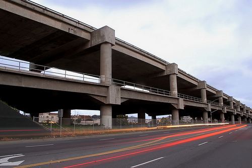
The Cypress Street Viaduct, often referred to as the Cypress Structure, was a 1.6 mile long, raised two-tier, multi-lane (four lanes per deck) freeway constructed of reinforced concrete that was originally part of the Nimitz Freeway (State Route 17, and later, Interstate 880) in Oakland, California.
Contents
- Worst engineering structures ever built cypress street viaduct
- Construction
- Loma Prieta earthquake
- Reconstruction around West Oakland
- Exit list
- Similar structures damaged by earthquakes
- References
It replaced an earlier single-deck viaduct constructed in the 1930s as one of the approaches to the San Francisco–Oakland Bay Bridge. It was located along Cypress Street between 7th Street and Interstate 80 in the West Oakland neighborhood.
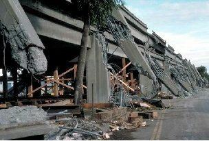
It officially opened to traffic on June 11, 1957 and was in use until the 1989 Loma Prieta earthquake, when much of the upper tier collapsed onto the lower tier, killing 42 people.
The Cypress Freeway Memorial Park is located in Oakland, at 14th Street and Mandela Parkway.
Construction
The double-decked viaduct was initially designed in 1949 by the City of Oakland as a way to ease traffic on local streets leading to the Bay Bridge, such as Cypress Street (which was California State Route 17 at the time). Built during the “white roads through black bedrooms” era, the route was partially chosen to displace perceived slums in West Oakland.
The southernmost portion of the Cypress Street viaduct, which was designed as a central offramp structure exiting at Market Street between Fifth and Sixth Streets to the Eighth Street/Seventh Street on/off ramps, was the first phase of the overall project completed in October, 1955, by contractors Frederickson and Watson at a cost of $1.7 million. Construction on the second phase of the project, the double-decked viaduct portion (which started from Adeline Street in the south to the MacArthur Maze in the north), began in February, 1956 by contractors Grove, Wilson, Shepard and Kruge at a cost of $8.3 million, bringing the total cost of the viaduct project to $10 million. It was California's first double-decked freeway when it officially opened to traffic on June 11, 1957.
Loma Prieta earthquake
On October 17, 1989, the portion of the structure from 16th Street north all the way to the MacArthur Maze collapsed during the 1989 Loma Prieta earthquake, due to ground movement and structural flaws.
When in use, the upper tier was used by southbound traffic, and the lower tier was used by northbound traffic. Some sections of the Cypress Street Viaduct were largely supported by two columns on either side, but some sections were only supported beneath by a single supporting column. The design was unable to survive the earthquake because the upper portions of the exterior columns were not tied by reinforcing to the lower columns, and the columns were not sufficiently ringed to prevent bursting. At the time of its design, such structures were not analyzed as a whole, and it appears that large structure motion contributed to the collapse. It was built on filled land on top of bay clay; filled land is highly susceptible to soil settlement during an earthquake, and bay clay exhibits larger ground motion.
After the earthquake stopped (with no aftershock), local residents and workers began crawling into and climbing upon the shattered structure with the goal of rescuing those left alive. Many were saved, some only by amputation of trapped limbs. The collapse of the upper tier onto the lower tier resulted in 42 fatalities—while this represented two-thirds of the total quake death toll of 63, it was a magnitude lower than initially feared; with San Francisco and Oakland in the World Series, many would-be commuters in both cities had left early or stayed late to watch the upcoming Game 3, and as a result traffic on the viaduct was far lighter at the time of the quake than it normally would have been.
After the viaduct was torn down, Cypress Street was renamed Mandela Parkway, in honor of Nelson Mandela, and a landscaped median strip was planted where the viaduct once stood. Before reconstruction occurred, the viaduct ended at the Eighth Street exit on the southern end, with the two roadways going over Seventh Street, while the southbound exit off the MacArthur Maze onto Cypress Street at 32nd Street remained open to local traffic on the northern end.
Reconstruction around West Oakland
In 1997, the Nimitz Freeway was rerouted to loop around the area using a largely ground-level design with more conventional single-level viaduct. The space was mainly taken from a railroad yard which was relocated. The exit at Eighth Street was eliminated, a southbound exit near Seventh and Union Street and a single northbound and southbound exit at Seventh Street, near the Port of Oakland was constructed also providing access via a frontage road to Grand Avenue and the Oakland Army Base, before a viaduct-type interchange splitting traffic to the Bay Bridge via Grand Avenue and also northbound to the Eastshore Freeway.
During construction of the new section of the Nimitz Freeway, a team of archaeologists made many interesting discoveries about the people who lived in West Oakland in the 19th century.
Due to cost overruns, the costs of the replacement freeway doubled from initial estimates of $650 million to $1.2 billion ($250 million per mile) making the five-mile freeway replacement the most expensive project in the state's history at the time. (It would be subsequently overshadowed by the northbound addition of the Benicia–Martinez Bridge and the Eastern span replacement of the San Francisco–Oakland Bay Bridge.) The cost overruns were mainly due to the opposition to replacing the highway on the site of the one partially destroyed in 1989, having to purchase land and property from Southern Pacific Railroad and Amtrak (moving part of the rail yard, and causing the earthquake-damaged 16th Street Amtrak Station to be closed and replaced with two Amtrak stations in Jack London Square and Emeryville) and the United States Postal Service (having to replace a parking lot with a parking garage), as well as replacing BART support beams and purchasing land from the U.S. Army (the freeway went through the Oakland Army Base to re-route the freeway).
Exit list
The entire route was in Oakland, Alameda County.