
Length 1,301 km | Constructed 1926 | |
 | ||
Existed: November 11, 1926 (1926-11-11) – present South end: I-5 / I-10 / SR 60 in Los Angeles North end: US 101 at Oregon state line Major cities San Francisco, Los Angeles, Santa Barbara, Santa Rosa, Eureka, Ventura, San Luis Obispo, Ukiah Similar West Oakland station, Richardson Grove State Park, Frog Woman Rock, Lake Mendocino, Dumbarton Bridge | ||
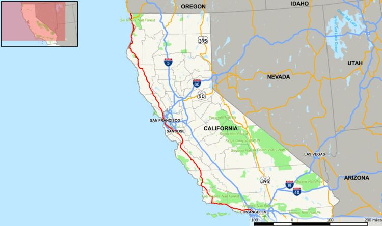
U.S. Route 101 (US 101) in the state of California is one of the last remaining and longest U.S. Routes still active in the state, and the longest highway of any kind in California. US 101 was also one of the original national routes established in 1926.
Contents
- Route description
- Los Angeles to Ventura
- Central Coast
- San Francisco Bay Area
- North Coast
- Juan Bautista de Anza National Historic Trail
- Historic route Los Angeles to San Diego
- OceansideCarlsbad freeway bypass
- El Camino Real Los Angeles to San Francisco
- Redwood Highway Marin County to Del Norte County
- Major intersections
- References
Although the highway has been superseded in overall importance for transport through the state by Interstate 5 (I-5), US 101 continues to be the major coastal north–south route that links the Greater Los Angeles Area, the Central Coast, the San Francisco Bay Area, and the North Coast (Redwood Empire). Significant portions of US 101 between the Los Angeles area and the San Francisco Bay Area follow El Camino Real, the historic road connecting the former Alta California's 21 missions. US 101 also has portions designated as the Santa Ana Freeway, Hollywood Freeway, Ventura Freeway, South Valley Freeway, and the Bayshore Freeway. The Redwood Highway, the 350-mile-long (560 km) northernmost segment of the highway, begins at the Golden Gate and passes through the world's tallest and only extensive preserves of virgin, old-growth coast redwood trees.
Route description
This route is part of the California Freeway and Expressway System.
Los Angeles to Ventura
The south terminus of US 101 is in Los Angeles, about one mile (1.6 km) east of downtown Los Angeles at the East Los Angeles Interchange, also known as the "Commuters' Complex". This southernmost portion is named the Santa Ana Freeway, inheriting that title as the northerly extension of the roadway now known as I-5.
After merging with westbound traffic from the San Bernardino Freeway (I-10), US 101 then proceeds northwest via the Downtown Slot under the northern edge of Los Angeles' Civic Center to State Route 110 (SR 110 at the Four Level Interchange. From here, US 101 becomes the Hollywood Freeway. It then heads to Hollywood and up through the Cahuenga Pass before reaching the San Fernando Valley.
US 101 then intersects with SR 134 and SR 170 at the interchange known as the Hollywood Split. Here, the alignment of US 101 shifts to the alignment of SR 134 (i.e. heading northbound, the road's alignment turns left, or westbound) and thereafter is referred to as the Ventura Freeway until it reaches Ventura. Though confusing, the "Hollywood Freeway" name continues northward from this interchange on SR 170, and the "Ventura Freeway" name continues eastward to SR 134.
From the Hollywood Split, US 101 is an east–west highway (until it reaches Gaviota State Park in Santa Barbara County where it shifts back to a north–south alignment). It meets with I-405 in Sherman Oaks, an interchange which holds claim to the most traveled intersection in the nation. The east–west geographical alignment of the Ventura Freeway and the north–south designation which appears on the freeway signs can be confusing to visitors; the same freeway entrance can often be signed as "101 North" and "101 West"; this is most common in the San Fernando Valley where the local E/W signing does not match the Caltrans' proper statewide N/S designation.
Upon reaching Ventura, there is an interchange with SR 126.
Central Coast
North of Ventura, US 101 switches intermittently between freeway and expressway status (i.e. there is occasional cross-traffic), but there are no traffic signals until San Francisco. The last traffic signals along this stretch of the route were removed in the early 1990s when the section through downtown Santa Barbara was constructed to freeway standards after years of disagreement over the impact that the original elevated design would have on the community.
From Ventura and through Santa Barbara, US 101 closely follows the Pacific coastline (generally no more than one to two miles [1.6 to 3.2 km] from the shore) until Gaviota State Park, about 23 miles (37 km) west of Goleta. At Gaviota State Park, the highway shifts back from an east–west highway to a north–south alignment. About one mile (1.6 km) north of this point, US 101 passes through the Gaviota Tunnel.
A few miles north of the Gaviota Tunnel, SR 1 splits from US 101 and heads northwest, running along the Pacific coastline parallel and to the west of US 101. US 101 passes through Buellton, Los Alamos, Orcutt, Santa Maria, and Nipomo. South of Santa Maria, US 101 widens from a four-lane highway to a six-lane freeway. SR 166 joins US 101 for about 3 miles (4.8 km) before splitting just north of the city limits, of which US 101 continues as a four-lane freeway before reverting to expressway status north of Nipomo.
Farther north, SR 1 rejoins US 101 between Pismo Beach and San Luis Obispo. Then US 101 takes an inland route through the Salinas Valley, while Highway 1 heads northwest, running along the Pacific coastline in California, parallel and to the west of US 101.
A steep segment (7% grade) between San Luis Obispo and Atascadero is known as the Cuesta Grade. North of Atascadero, the highway joins SR 46 for about three miles (4.8 km) through Paso Robles.
From Paso Robles to Salinas, US 101 is an expressway known as the Salinas River Valley Highway, since the Salinas River Valley extends from Santa Margarita to the SR 156 junction in Prunedale. US 101 resumes freeway status between San Miguel and King City, passing through the smaller towns of Camp Roberts, Bradley, and San Ardo, as well as the San Ardo Oil Field about five miles (8.0 km) south of San Ardo. Near this point, the wide agricultural bottomlands of the Salinas Valley begins. North of King City, US 101 once again switches intermittently between freeway and expressway status, passing through Greenfield, Soledad, Gonzales, and Chualar before reaching Salinas. Shortly after leaving Salinas, US 101 joins SR 156 in Prunedale for about eight miles (13 km). After crossing the San Benito County line, SR 156 splits from US 101 near San Juan Bautista while US 101 continues northward mostly as a four-lane highway until it reaches Gilroy.
San Francisco Bay Area
US 101 crosses the Pajaro River into Santa Clara County as a four-lane highway, with an interchange at SR 25 a few miles later. Upon reaching Gilroy, it becomes the South Valley Freeway, and at the same time, it expands to three lanes in each direction. It then heads through the suburb of Morgan Hill, and shortly afterwards expands to four lanes in each direction, with a HOV lane in the middle, before reaching San Jose. From San Jose to San Francisco, US 101 is known as the Bayshore Freeway as it passes through Palo Alto and the other major communities along the San Francisco Peninsula.
US 101 is called the James Lick Freeway, named for James Lick, a philanthropist, from the San Francisco county/city line, through the interchange with I-280 at the Alemany Maze, until the junction with the San Francisco Skyway (I-80) and the Central Freeway near the city's Civic Center. US 101 continues in a northwestern direction on the Central Freeway, and then leaves the freeway, on Mission Street (northbound) and South Van Ness Avenue (southbound), to run north on Van Ness Avenue. At the intersection of Van Ness Avenue and Lombard Street, US 101 heads west on Lombard Street, and then on Richardson Avenue, entering The Presidio, where it becomes a divided highway again (the partially built Presidio Parkway). It is then joined by Route 1 before approaching and crossing the Golden Gate Bridge.
From San Francisco north the highway is heavily traveled by commuters through to Windsor, just north of Santa Rosa. North of the Golden Gate Bridge, US 101 enters Marin County and is known as the Redwood Highway. After crossing the bridge, US 101 climbs the Waldo Grade and passes through the Robin Williams Tunnel, the first of its kind in 300 miles (480 km) (the other being the Gaviota Tunnel in Santa Barbara County). Upon exiting the tunnel, it passes above the hillside town of Sausalito and descends to Richardson Bay, where SR 1 splits from the freeway and heads to the coast. US 101 then passes through Mill Valley, Corte Madera, Larkspur, San Rafael and Novato, before entering Sonoma County. The section between Novato in Marin County and Petaluma in Sonoma County changes from its original six or eight lanes through Marin to four lanes, creating a bottleneck, and is thus called the "Novato Narrows" by locals. The Narrows continue up to North of Petaluma. The entire area between Novato and Petaluma is also the voter approved Novato–Petaluma Community Separator, which forbids most development.
Upon entering Sonoma County, it continues as a four-lane highway until Petaluma, where it resumes freeway status and eventually a six-lane freeway between Petaluma and Windsor, passing through Cotati, Rohnert Park, and Santa Rosa. Upon reaching Windsor, the freeway returns to two lanes in each direction, passing through Healdsburg. It then proceeds up the Alexander Valley with the Russian River. SR 128 joins US 101 in the town of Geyserville before splitting just north of Cloverdale. US 101 then heads up a steep hill just before leaving Sonoma County and entering Mendocino County.
North Coast
US 101 crosses into the Mendocino County line as a freeway for one mile (1.6 km), but then narrows to an expressway through the Russian River canyon and eventually a two-lane road south of Hopland, the first time since leaving San Francisco. Just before reaching Ukiah, US 101 becomes a four-lane freeway. In the community of Calpella, SR 20 merges with US 101 for the next 15.5 miles (24.9 km) to Willits. The freeway portion ends as the combined US 101 and SR 20 ascend the 1,953-foot (595 m) Ridgewood Summit, the highest elevation along the route's 807-mile-long (1,299 km) trek through California.
US 101 leaves Willits as a two-lane road, but soon widens to a four-lane expressway until the intersection with the western portion of SR 162, where it reverts to a two-lane road. North of Laytonville, US 101 ascends Rattlesnake summit (1,796 feet or 547 metres) before a descent to follow the South Fork Eel River and Eel River all the way to Fortuna near the mouth of the river. About 12 miles (19 km) northwest of Laytonville, US 101 becomes an undivided freeway near the community of Cummings. SR 271 is the old portion of US 101 through this area. At Leggett, US 101 meets SR 1 for the last time, and from this point until Piercy, US 101 runs along a section of highway with frequent landslides. Cal Trans bypassed the most difficult section in 2009 with unique construction of two bridges known collectively as the Confusion Hill Bridges. This project, funded by an emergency act from the State Legislature, moved the highway across the Eel River away from the troubled spots to prevent disruption in commerce and travel from infrequent, but costly, winter closures on the main transportation route to the far North Coast. North of Piercy, the freeway portion again ends and the road narrows down to two lanes, before another stretch of divided highway.
Arriving in Humboldt County, another narrow two lane portion of US 101 bisects Richardson Grove State Park. Just after the park boundary, the highway switches to a short undivided freeway and then eventually a divided freeway just before reaching Garberville. North of Garberville, US 101 reverts to an undivided freeway, which continuing north by northwest, passes through the 53,000-acre (210 km2) Humboldt Redwoods State Park, California's third largest State Park and the site of the largest remaining Redwood old growth forest in the world. A preserved portion of the original, bypassed highway route, known as the Avenue of the Giants for the huge, centuries-old redwood trees, parallels the highway for over 30 miles (48 km) in southern Humboldt County. US 101 again switches to another stretch of divided freeway near the town Pepperwood before reverting to a short, 2-mile (3 km) expressway just north of Stafford. A short freeway then runs through Rio Dell before another short, 3-mile (5 km) expressway.
Shortly before reaching the western terminus of SR 36, US 101 becomes a freeway again between Fortuna and Eureka. North of Humboldt Hill, the road enters the City of Eureka (a potential new freeway cutting through or bypass of the city was successfully blocked repeatedly). As the route traverses Eureka, the southern portion is known as "Broadway" and then as it bears east along Humboldt Bay, the Highway is aligned on a one-way couplet (4th and 5th streets). Five miles (8.0 km) later the highway leaves Eureka's northern city limit and continues north. The expressway style section between Eureka and Arcata, which is also a safety corridor, is named the "Michael J. Burns Freeway," in honor of the State Senator who was a proponent of California's Highways. The Highway becomes an unobstructed Freeway south of the center of Arcata. Proceeding north it passes the junction for SR 299 (also the western terminus for that route), in the Valley West (northernmost) part of the college town.
The highway continues north as it skirts westerly around McKinleyville on a high bluff north of the Mad River. As the highway reaches Clam Beach (a county park), motorists get their first magnificent full view of the Pacific Ocean north of the Golden Gate. North of Trinidad, the highway narrows to one lane in each direction after crossing Big Lagoon to pass inland of Stone Lagoon and follow the coastal bar between Freshwater Lagoon and the Pacific Ocean south of Orick. After a 14-mile (23 km) freeway section through Redwood National and State Parks running inland east of the Prairie Creek Redwoods State Park boundary, the highway again narrows to one lane in each direction at the Klamath River. The original placement of the highway near giant Coast Redwoods led to increased awareness of the destruction of the redwoods after decades of extensive logging, which ultimately led to the establishment of Redwood National Park in 1968. The original highway segment through Prairie Creek Redwoods State Park is now a scenic alternate similar to Avenue of the Giants, named Newton B. Drury Scenic Parkway in honor of the fourth director of the National Park Service and executive director of the Save-the-Redwoods League
North of the town of Klamath just inside Del Norte County, the highway closely follows the Pacific coast again. In Crescent City, US 101 once again separates into a one-way couplet (L and M Streets) for nine blocks. As it leaves Crescent City, US 101 becomes a divided freeway for the last time in California (built slightly to the west of the original two-lane alignment, now called Parkway Drive). As the 3-mile divided freeway portion ends, US 101 intersects the southern terminus of US 199, which heads northeast as the Redwood Highway, terminating in Grants Pass, Oregon. US 101 (no longer called the "Redwood Highway" at this point) is reduced to two lanes and continues north along the California coast until it reaches the Oregon border.
Juan Bautista de Anza National Historic Trail
The US 101 Highway is part of the auto tour route of the Juan Bautista de Anza National Historic Trail, a National Park Service unit in the United States National Historic Trail and National Millennium Trail programs. In 2005, Caltrans began posting signs on roads that overlap with the historic 1776 Juan Bautista de Anza trail route, so that California drivers can now follow the trail.
Historic route: Los Angeles to San Diego
Instead of terminating in Los Angeles, US 101 once continued all the way south through San Diego to the United States–Mexico border in San Ysidro. However, this part was decommissioned on July 1, 1964, in favor of I-5. The only remnant of the old route on US 101's current alignment is a mileage sign at the Santa Barbara–Ventura county line, which lists the distance to San Diego, even though US 101 ends in Los Angeles.
Oceanside–Carlsbad freeway bypass
By the early 1950s, traffic had become very heavy on US 101 through Oceanside and Carlsbad. The US 101 freeway bypass (Oceanside-Carlsbad freeway bypass) was built in 1953 and completed in 1955 by the California Department of Public Works (now Caltrans) and brought up by the San Diego Highway Development Association on a US 80/US 101 discussion on how to resolve the huge traffic loads on US 101 in Oceanside. Today it is part of I-5 and Palomar Airport Road. It follows I-5 from Coast Highway (former Hill Street exit) in Oceanside to Palomar Airport Road in Carlsbad. From there the US 101 bypass went onto Palomar Airport Road to merge with US 101 Bus. on Carlsbad Boulevard. As it approached the Coast Highway/SR 76 exit on southbound I-5 in Oceanside, US 101 Bus. split off. US 101 Bus. followed the original US 101 through downtown Oceanside and Carlsbad as former Hill Street/Carlsbad Boulevard (CR S-21) while the US 101 freeway followed modern I-5 and Palomar Airport Road. The south end of the freeway bypass is Carlsbad Boulevard and Palomar Airport Road and the north end is I-5 and the Coast Highway/SR 76 exit. The south end was modified after US 101 was decommissioned between the East Los Angeles Interchange in Los Angeles and the Mexican border in San Ysidro. This freeway construction by the California Department of Public Works put US 101 on an all new highway route alignment to relieve Oceanside and Carlsbad of their very heavy bumper-to-bumper burdensome traffic problem. Also before the bypass in the 1950s, US 101 followed North Coast Highway (formerly Hill Street) from San Luis Rey Mission Expressway (SR 76 and north end of the Oceanside–Carlsbad freeway bypass) to Harbor Drive. From there it followed Harbor Drive to Vandergrift Boulevard, San Rafael Drive, and the freeway onramp for I-5 north near the Camp Pendleton north entrance guardhouse gate. It merges with the I-5 northbound onramp to shoot onto the southbound lanes of I-5 to follow the freeway lanes all the way to Las Pulgas Road in Camp Pendleton.
El Camino Real: Los Angeles to San Francisco
Significant portions of US 101 from its southern terminus to the San Francisco Bay Area is designated as the Royal Road or El Camino Real. The route roughly follows the historic trail that connected the former Alta California's 21 missions.
Before the Golden Gate Bridge was completed in 1937, there was regular vehicle ferry service across the Golden Gate strait. Under the California Streets and Highways Code § 401, the Golden Gate Bridge is legally not part of US 101. The portion of US 101 starting from Los Angeles ends at "the approach to the Golden Gate Bridge" and then resumes at "a point in Marin County opposite San Francisco" to the Oregon state line. The bridge itself is maintained by the Golden Gate Bridge, Highway and Transportation District instead of Caltrans.
From the 1940s to 1991, various segments of US 101 between Los Angeles and San Francisco were upgraded to either a freeway or expressway. In the Los Angeles area, the first segment of the Hollywood Freeway through the Cahuenga Pass opened in 1940, while the segment from the San Fernando Valley to Downtown Los Angeles opened in 1954. The Ventura Freeway then opened in 1960. The segment of the original two-lane alignment between Emma Wood State Beach north to the Mobil Pier Undercrossing near Sea Cliff, which followed the historic Rincon Sea Level Road, was the re-signed as part of SR 1.
In the San Francisco Bay Area, US 101 was originally divided. US 101W followed the same general right-of-way of today's US 101 through the region, primarily along what was originally signed as Bayshore Boulevard. US 101E then generally followed the right-of-way taken by today's I-880 from San Jose to Oakland, then across the Carquinez Bridge to follow what is now SR 37, joining US 101W. The US 101E designation was removed by the 1940s and became SR 17 (later designated as I-880 and the westernmost section I-580), running from San Jose to Oakland and then across the Richmond–San Rafael Bridge. Meanwhile, Bayshore Boulevard was later redesignated as the US 101A bypass and then eventually upgraded to what is now the Bayshore Freeway. The first stretch that was completed between Redwood City and South San Francisco was the Bay Area's first freeway when it opened in 1947. After the entire Bayshore Freeway was completed in the early 1960s, the old alignment along the peninsula was renumbered and renamed as SR 82/El Camino Real.
Various other freeway or expressway bypasses along the California Central Coast were also built. In 1991, the last traffic signal along US 101 between Los Angeles and San Francisco was taken down in Santa Barbara. The primary control city that is listed on freeway signs along northbound US 101 through the Central Coast region remains San Francisco. Although San Jose surpassed San Francisco population decades after the highway was built, there has been no push to change all the signs.
As the result of freeway revolts in San Francisco in the 1950s, a direct freeway connection through the city to the Golden Gate Bridge has never been built. The Central Freeway was completed to extend from the Bayshore Freeway to Turk Street in 1959, before the San Francisco Board of Supervisors voted to remove the remainder of the Central Freeway and most other proposed freeways from the city's highway plan. For decades, southbound traffic on US 101 flowed on the one-way Turk Street from Van Ness Avenue to the Central Freeway, while northbound traffic used the parallel Golden Gate Avenue. After the 1989 Loma Prieta earthquake damaged the structure, the segment of the Central Freeway north of Market Street was replaced with the surface-level Octavia Boulevard; traffic on US 101 was then eventually re-routed to exit south of that at Mission Street/South Van Ness Avenue. With no direct freeway along US 101 through the City of San Francisco, the old US 101E/I-880/I-580 route remains as a faster bypass through the Bay Area.
In 2003, the segment of US 101 between Morgan Hill and San Jose, also known as the Sig Sanchez Freeway, expanded to eight lanes between Cochrane Road and SR 85 exits. Originally, the ten-mile segment was only four lanes. The improved segment was to alleviate the consistent congestion that had expanded as far south as Masten Avenue coming from Gilroy, and as far north as Bernal Road coming from San Jose. Traffic now typically only runs slow between the Bailey Avenue and Dunne Avenue exits.
The interchange at the beginning of I-280 and I-680 was constructed years before it its completion. The two bridges, with no on ramps or off ramps stood over US 101 as a 110-foot-tall (34 m) monument to inefficiency for years in the 1970s. It became the butt of many local jokes. The highlight prank occurred in January 1976, when a 1960 Chevrolet Impala was placed on the highest bridge overnight, where it obviously would be impossible to drive. The following day, San Jose City Councilman Joe Colla was photographed standing next to the car, a photo which was circulated across many newspapers. It has been suggested this stunt nudged the wheels of progress to find the funds to complete the freeway. In 2010, the interchange was named the Joe Colla Interchange.
Redwood Highway: Marin County to Del Norte County
A segment of the Redwood Highway, US 101, located in the Redwood National and State Parks near Klamath was added to the National Register of Historic Places in 1979.
Freeway segments along the Redwood Highway portion of US 101 are not as prevalent as along the Los Angeles-San Francisco route. A notable segment of the old US 101 alignment is SR 254, also known as the Avenue of the Giants, in Humboldt Redwoods State Park. The freeway bypassing this scenic route, surrounded by towering Coast Redwoods, was completed in 1960. Several bridges along the segment of highway running along the Eel River were destroyed during the Christmas flood of 1964.
The city of Eureka has long resisted a freeway through it. Another freeway bypass currently under construction that will bypass Willits remains controversial because the intended route goes through protected wetlands.
Major intersections
Except where prefixed with a letter, postmiles were measured on the road as it was in 1964, based on the alignment that existed at the time, and do not necessarily reflect current mileage. R reflects a realignment in the route since then, M indicates a second realignment, L refers an overlap due to a correction or change, and T indicates postmiles classified as temporary (for a full list of prefixes, see the list of postmile definitions). Segments that remain unconstructed or have been relinquished to local control may be omitted. The numbers reset at county lines; the start and end postmiles in each county are given in the county column.