This is a list of islands whose land is divided by one or more international borders.
Lake islands
Among Norway, Sweden and Finland:Three-Country Cairn, the boundary cairn at the tripoint, is 10 metres from the shore of Lake Goldajärvi/Koltajauri, and hence arguably a tiny artificial island. Around 14 m².Between the United States and Canada:A lake island at 62.649677°N 141°W / 62.649677; -141, north of the Yukon–Alaska Highway border crossingA lake island at 62.641158°N 141°W / 62.641158; -141, north of the Yukon–Alaska Highway border crossingA lake island at 62.637174°N 141°W / 62.637174; -141, just north of the Yukon–Alaska Highway border crossingTwo islands in a small lake at 62.538443°N 141°W / 62.538443; -141, 8.2 km south of the Yukon–Alaska Highway border crossingSeveral rocky islets in a small lake on the Okanogan County, Washington/British Columbia border at 49°N 120.177376°W / 49; -120.177376An island in a small lake on the Okanogan County, Washington/British Columbia border at 49°N 120.172980°W / 49; -120.172980An island in a small lake adjacent to the Milk River at 49°N 110.546975°W / 49; -110.546975 in Montana/AlbertaAn island in Salt Lake (Alkali Lake) 49°N 104.311173°W / 49; -104.311173 in Montana/SaskatchewanAn island in Brush Lake at 49°N 103.981638°W / 49; -103.981638 in North Dakota/SaskatchewanTwo islands in Boundary Lake at 49°N 100.217095°W / 49; -100.217095, in North Dakota/ManitobaAn island in Lake Metigoshe at 49°N 100.353901°W / 49; -100.353901 in North Dakota/ManitobaAn islet east of Ross Lake at 49°N 100.298939°W / 49; -100.298939 in North Dakota/ManitobaAn island in a small lake on the Rolette County, North Dakota/Manitoba border at 49°N 100.013149°W / 49; -100.013149An island in a small lake on the Towner County, North Dakota/Manitoba border at 49°N 99.218163°W / 49; -99.218163An island in a small lake on the Cavalier County, North Dakota/Manitoba border at 49°N 98.541357°W / 49; -98.541357An islet in a small reservoir (when filled) just east of the Maida port of entry on North Dakota Highway 1 at 49.000253°N 98.356943°W / 49.000253; -98.356943, North Dakota/ManitobaAn island in a small lake on the border of Maine/New Brunswick at 46.004988°N 67.7810°W / 46.004988; -67.7810, southeast of Hodgdon, MaineProvince Island in Lake Memphremagog, between Quebec (91%) and Vermont (9%) Between Norway and Russia:In Klistervatn: Store GrenenholmenIn Grensevatn: Korkeasaari and an unnamed isletBetween Finland and Russia:Äikkäänniemi in NuijamaanjärviSuursaari and a smaller island in Yla-TirjaTarraassiinsaari, Härkäsaari, and Kiteensaari in MelaselänjärviIsland in VirmajärviRajasaari in KokkojärviKalmasaari in VuokkijärviVarposaari in HietajärviParvajärvensaari in ParvajärviKeuhkosaari in Pukarijärvi / Ozero PyukharinSiiheojansuusaari and Tossensaari in Onkamojärvi / Ozero OnkamoBetween Finland and Norway:Island in Kivisarijärvi/KeđgisualuijävriIsland in lake SE of boundary marker 347ABetween Sweden and Norway:Island in Sör Vammsjön/Vammen SøndreHisön/Hisøya in Norra Kornsjön/Nordre Kornsjø (≈0,09 km²)Kulleholmen/Kalholmen (≈5500 m²) and Tagholm/Tåkeholmen (≈600 m²) in Södra Boksjön/Søndre BoksjøSalholmen and Trollön/Trolløya in Stora Le/Store LeIsland in Tannsjøen/TannsjönLinneholmene in HelgesjöJensøya in HolmsjøenStorøya in UtgardsjøenFallsjøholmen in Fallsjøen (Nordre Røgden)Island in KroksjøenIsland in VonsjøenIsland in Skurdalssjøen/KruehkiejaevrieIsland in a lake at altitude 710m on the Gihcijoka riverThree islands in ČoarvejávriBetween Lithuania and Belarus:Sosnovec and another nameless island in Lake DrūkšiaiBetween the United Kingdom and Ireland:Pollatawny in Lough Vearty.Between Ethiopia and Djibouti:Island off Cape Aleilou in Lake AbbeThe border between Austria and Hungary cuts across the Neusiedler See/Fertő tó, where the water level fluctuates, sometimes exposing island flats which straddle the border.River islands
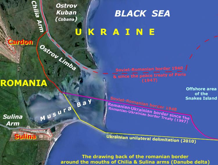
Island (Staustufe Apach) in the Moselle River near Schengen: mostly in France, the tip is in the Moselle condominium shared by Luxembourg and GermanyBolshoy Ussuriyskiy (Heixiazi) at the confluence of the Ussuri and Amur rivers, between the People's Republic of China and Russia.Bolshoy (Abagaitu) at the Argun River, between the People's Republic of China and Russia.An island in the Šešupė River divided between Lithuania and the Kaliningrad Oblast of RussiaCorocoro Island in the delta of the Barima River: split between Venezuela and GuyanaSan Jose Island, Río Negro: between Colombia and Brazil.The island complex Martín García – Timoteo Domínguez in the Río de la Plata between Argentina and Uruguay.The lower reaches of the Ganges, Teesta, and Brahmaputra Rivers, approaching the Ganges Delta, are braided and contain numerous sand islands called chars. These can be large and inhabited but are impermanent. At any given time, several are likely to straddle the border between India (Assam and West Bengal) and Bangladesh, though this border is not fully specified.An island labelled 'Q' in the Maritsa River, between Greece and Turkey.An islet in the Uutuanjoki, between Finland and Norway, at 69.579665°N 29.231701°E / 69.579665; 29.231701.An islet in the Vadet near Tunnsjø, between Norway and Sweden, at 64.644443°N 13.71056°E / 64.644443; 13.71056.An islet on the western side of the golf course that straddles the municipalities of Tornio in Finland, and Haparanda in Sweden, at 65.861513°N 24.129624°E / 65.861513; 24.129624.An islet in the Euphrates River on the border of Iraq and Syria.Nokiel and another unnamed islet in the Dunajec river, between Slovakia and Poland, at 49.3984°N 20.359726°E / 49.3984; 20.359726.Nicaragua and Honduras share four islands along a straight-line border in the delta of the Río Negro at the Gulf of Fonseca.Canada / USA:9 islands serially located in the Clarence River on the Alaska North Slope near Demarcation Bay; northernmost at 69.616789°N 141°W / 69.616789; -141, southernmost at 69.557094°N 141°W / 69.557094; -141One or more islands in Trail Creek at 68.881754°N 141°W / 68.881754; -141, northeast of Arctic Village, AlaskaAn island in Mancha Creek at 68.663957°N 141°W / 68.663957; -141, northeast of Arctic Village, AK6 (or more) islands in bifurcated flow in the Firth River at 68.641781°N 141°W / 68.641781; -141, northeast of Arctic Village, AKAn island in Sunaghun Creek at 67.426117°N 141°W / 67.426117; -141, near its mouth at the Porcupine River, downstream of Old Crow, YukonAn island in the watershed of the Bluefish River at 66.838155°N 141°W / 66.838155; -141, east of Chalkyitsik, Alaska and 15 km WWSW of Bluefish Lake, Yukon.An island in Fort Creek at 66.759004°N 141°W / 66.759004; -141, east of Chalkyitsik, AKAn island in the Black River (Salmon Fork) at 66.543661°N 141°W / 66.543661; -141, east of Chalkyitsik, AKAn island in Beaver Creek at 62.227460°N 141°W / 62.227460; -141, southwest of Beaver Creek, YukonTwo islands in Klehini River at 59.448142°N 136.365213°W / 59.448142; -136.365213, near Klukwan, Alaska11 (or more) islands in bifurcated river flow on Whiting River at 58.184862°N 133.221034°W / 58.184862; -133.221034, upstream of Gilbert Bay, which empties into Stephens PassageTwo islands in Stikine River at 56.658546°N 131.848698°W / 56.658546; -131.848698, downstream of Great Glacier, YukonAn island in Columbia River at Waneta border crossing at 49.004380°N 117.640936°W / 49.004380; -117.640936 in Washington/British ColumbiaAn island in Belly River at 49°N 113.683294°W / 49; -113.683294 in Montana/AlbertaAn island in a branch of Lee Creek at 49°N 113.600862°W / 49; -113.600862 in Montana/AlbertaAn islet in Boundary Creek at 49°N 113.357300°W / 49; -113.357300 in Montana/AlbertaAn island in St. Mary River 49°N 113.326222°W / 49; -113.326222 in Montana/AlbertaAn islet in Milk River at 48.998739°N 112.555541°W / 48.998739; -112.555541 in Montana/AlbertaAn island in Mundell Creek at 49°N 109.089222°W / 49; -109.089222 in Montana/SaskatchewanAn island in McEachern Creek at 49°N 106.938504°W / 49; -106.938504 in Montana/SaskatchewanAn island in the Pembina River at 49.000288°N 98.206118°W / 49.000288; -98.206118 in North Dakota/ManitobaAn island in tributary of Northwest Branch Saint John River at 46.687062°N 69.998996°W / 46.687062; -69.998996 in Maine/QuebecAn island in North Branch Meduxnekeag River at 46.276686°N 67.782°W / 46.276686; -67.782 in Maine/New BrunswickTwo islands on the Maine/New Brunswick border southeast of Monticello, Maine (46.272890°N 67.782°W / 46.272890; -67.782 and 46.272293°N 67.782°W / 46.272293; -67.782) that are formed by the forks of a stream that rises from Gentle Lake in Maine, then flows into the North Branch–Meduxnekeag River.Historically divided islands
Other islands have been divided by international borders in the past but they are now unified.
The definite borders of modern nation-states do not apply in other forms of societal organisation, where "divided" islands may consequently be less noteworthy. For example, in Ancient Greece, the island of Euboea was divided among several city states, including Chalcis and Eretria; and before its settlement by Europeans, the Island of Tasmania was divided among nine indigenous tribes.
Islands in wartime may be divided between an invading and defending power, as with Crete in 1645–69 between the Ottoman Empire and the Republic of Venice.
Examples of formerly divided islands include:
Corsica – was divided between the Republic of Pisa and the Republic of Genoa by a ruling by Pope Innocent II in 1132, and it remained so until the Battle of Meloria of 1284. Then Corsica successively became part of Genoa, Aragon, Genoa again, the Corsican Republic, France, Anglo-Corsican Kingdom, and finally France again.Sardinia – was divided into indigenous giudicati since before the year 900 through the extinction of the Giudicato of Arborea in 1420. Since then, Sardina has successively has been part of Aragon, the Spanish Empire, Piedmont-Sardinia, the Kingdom of Italy, and the Republic of Italy.Saaremaa (1237–1570) and Hiiumaa (1254–1563) – Divided between the Livonian Order and the Bishopric of Ösel-Wiek (the Kingdom of Denmark after 1560). Thereafter these were part of Denmark (Saaremaa only), the Kingdom of Sweden, Imperial Russia, Estonia, the U.S.S.R., Nazi Germany (1941–44), the U.S.S.R. again, and finally Estonia after the dissolution of the U.S.S.R. in 1991.Tobago – from 1654 through 1659, this island had colonies from both the Duchy of Courland and Semigallia and the Dutch Republic. Both of these colonies failed economically and were abandoned. Later, Tobago became part of the French Empire, then the Kingdom of Great Britain (1706), the United Kingdom of Great Britain and Ireland, the present United Kingdom, and the independent country of Trinidad and Tobago.Ternate – divided between the Spanish Empire allied with Tidore, and the Dutch Republic allied with the Sultan of Ternate from 1607 through 1663. Later, Ternate has successive been owned by the Netherlands, the Japanese Empire (1942–45), Netherlands again, and the independent country of Indonesia, beginning in 1949.Long Island, New York – divided between the Dutch Republic and the Kingdom of England beginning in 1640 (de facto, by the founding of the Southold), or in 1650 (de jure, by the Treaty of Hartford), through to the surrender of New Netherland to the British Army in 1664. Thereafter, Long Island has been owned by Kingdom of England, the United Kingdom, and the United States from 1781 through the present. Long Island has been part of the State of New York since 1781, and it is the largest island in the Contiguous United States (48 states).Great Britain – Earlier divided into three or more kingdoms, including England, Wales, and Scotland, and sometimes ruled in part by the Roman Empire and the Danish Empire. These parts were reduced to just two before 1707, when the Kingdom of England and the Kingdom of Scotland enacted the Acts of Union of 1707, establishing just one monarchy and one parliament. Since 1707, England, Scotland, and Wales have been part of (successively) the Kingdom of Great Britain, the United Kingdom of Great Britain and Ireland, and the United Kingdom of Great Britain and Northern Ireland, often called the United Kingdom for short.Newfoundland Island – Earlier divided between Great Britain and the French Empire until the enactment of the Treaty of Utrecht in 1713. Following this treaty, Newfoundland was part of the British Empire. Then it became the partially independent Dominion of Newfoundland, which next became a Province of Canada in 1949.Saint Kitts – Divided between Great Britain and the French Empire in 1628. "The island fell to the French in April 1666, but by the Treaty of Utrecht, April 11, 1713, it was yielded entirely to the British crown." Then it became part of the British Empire for about 250 years, and finally part of the independent country of Saint Kitts and Nevis. At various times of war in the Caribbean Sea, either France or Great Britain occupied all of Saint Kitts both before and after 1713.Elba – divided from 1548 through 1802. Portoferraio belonged to the Duke of Florence (later the Grand Duchy of Tuscany) from 1548 until this was ceded to France in 1802 under the Treaty of Amiens. Porto Longone belonged to the State of Presidi, a client of first the Spanish Empire and then the Kingdom of Naples, from 1557 until ceded to France in 1801 by the Treaty of Florence. The rest of this island belonged to the Principality of Piombino until conquered by the French Empire, and then in 1802 Napoleon made Elba into the Kingdom of Etruria. This island was successively part of the French Empire, the Principality of Piombino under Elisa Baciocchi, under the sovereignty of Napoleon by the terms of the Treaty of Fontainebleau (1814), part of Tuscany again, part of the Kingdom of Italy, Italian Social Republic (1943–44), and finally part of the Republic of Italy.Efate – Divided for several months during 1889 between Franceville and the New Hebrides, then under an Anglo-French joint naval commission.Sakhalin Island – Divided between the Russian Empire, then the U.S.S.R., and the Japanese Empire along the 50th parallel north by the terms of the Treaty of Portsmouth of 1905 through the final Surrender of the Japanese Empire in 1945. Henceforth, all of Sakhalin became part of the U.S.S.R., and then the Russian Federation, de facto. The Japanese Empire still considers the ownership of Sakhalin to be undetermined, and Sakhalin is shown on many Japanese maps as a "no man's land".Killiniq Island – divided between Canada and the Colony of Newfoundland and then the Dominion of Newfoundland beginning with the Founding of Canada in 1867 through 1949 with the addition of Newfoundland to Canada.Ankoko Island in the Cuyuni River on the border between Venezuela and British Guiana (now Guyana).Zhongshan Dao in the Pearl River Delta was divided between China and Macau from ratification of the Treaty of Tientsin in 1862 through the final return of Macao to China in the year 1999.Frijoles Island within Gatun Lake in the former Panama Canal Zone was split between the United States and Panama on 1 October 1979, the date that the 1977 Panama Canal Treaty took effect. Much of the former Canal Zone area was transferred to Panama on that day. The Panama Railroad served as the new border in an area where it crosses Gatun Lake via a causeway, with the railroad bisecting Frijoles Island. The entire island transferred to exclusive Panamanian jurisdiction on 31 December 1999.The small middle island of Las Tres Hermanas ("The Three Sisters") off the Pacific coast of Panama City was split between the U.S. Panama Canal Zone and Panama by the Taft Agreement on 12 December 1904. The entire island was placed in the Canal Zone on 11 February 1915. Today the Cinta Costera lies on top of it.Popes Folly Island in Passamaquoddy Bay between the United States (Maine) and Canada (New Brunswick) had been divided prior to the 1908 border treaty between the U.S. and Great Britain.A few former islands have disappeared because of changes in water levels:
Vozrozhdeniya Island in the Aral Sea was split between the Soviet Republics of Uzbekistan and Kazakhstan. This border became an international one in 1991 when the U.S.S.R. was dissolved. By the year 2002, this island had become a peninsula of the mainland because of the falling water level of the Aral Sea.The small Bogomerom archipelago of islets in Lake Chad was formerly divided between Chad and Nigeria. The water level of Lake Chad has historically varied a lot, but this level has fallen so low that these islets are now part of the mainland of Africa.Subnational divided islands
There are islands that lie across different provinces or states of the same country. An example would be Killiniq Island of Canada, which is divided between Newfoundland and Labrador and Nunavut, whereas Melville Island and Victoria Island are divided between Nunavut and the Northwest Territories. In Australia, the Boundary Islet is divided between Tasmania and Victoria. Smith Island in Chesapeake Bay and Assateague Island, a barrier island on the Atlantic coast of the United States, are divided between the states of Maryland and Virginia. Fenwick Island, on the coast immediately to the north, is divided between Maryland and Delaware. Ellis Island, itself in the United States state of New Jersey, contains a true exclave of the state of New York; elsewhere in New York Harbor, the northern tip of Shooters Island, otherwise in New York, is in New Jersey. Zhongshan Island, in China, is divided between the province of Guangdong and the special administrative region of Macau.
The island of Ceylon (Sri Lanka) has also two nationalities – Sinhalese and Tamils. Tamils live in the North and Eastern Provinces, whereas Sinhala people live in other provinces. Tamils call their place Eelam. The island is naturally divided when mapped by language, religion and ethnicity race.