
Existed: 1913 – present East end: Washington, D.C. | Constructed 1913 | |
 | ||
States: California, Arizona, New Mexico, Texas, Louisiana, Mississippi, Alabama, Georgia, South Carolina, North Carolina, Virginia | ||
The Jefferson Davis Highway was a planned transcontinental highway in the United States in the 1910s and 1920s that began in Washington, D.C., and extended south and west to San Diego, California; it was named for Jefferson Davis, who, in addition to being the first and only President of the Confederate States of America was also a U.S. Congressman and Secretary of War. Because of unintended conflict between the National Auto Trail movement and the federal government, it is unclear whether the Jefferson Davis highway ever really existed in the complete form that its founders originally intended.
Contents
- Map of Jefferson Davis Hwy Virginia USA
- Background
- End of the auto trails
- Remaining portions
- Virginia
- North Carolina
- South Carolina
- Georgia
- Alabama
- Mississippi
- Texas
- New Mexico
- California
- Washington
- References
Map of Jefferson Davis Hwy, Virginia, USA
Background
In the first quarter of the 20th century, as the automobile gained in popularity, a system of roads began to develop informally through the actions of private interests, these were known as auto trails. They existed without the support or coordination of the federal government, although in some states, the state governments participated in their planning and development. The first of these National Auto Trails was the Lincoln Highway, which was first announced as a project in 1912.
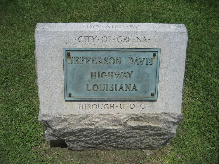
With the need for new roads being so significant, dozens of new auto trails were begun in the decade following. One such roadway was the Jefferson Davis Memorial Highway, which was sponsored by the United Daughters of the Confederacy. The UDC planned the formation of the Jefferson Davis as a road that would start in Washington, D.C. and travel through the southern states until its terminus at San Diego. More than ten years after the construction of the Jefferson Davis was begun, it was announced that it would be extended north out of San Diego and go to the Canada–US border.
End of the auto trails
In the mid-1920s, the disparate system of national auto trails had grown cumbersome, and the federal government imposed a numbering system on the nations's highways. Using a system of even numbers for east–west routes and odd numbers for north–south routes, the numbers were imposed on the auto trails. And rather than designate one number for each auto trail, different sections of each trail were given different numerical designations. However the UDC petitioned the U.S. Bureau of Public Roads to designate the Jefferson Davis as a national highway with a single number. The Bureau's reply casts doubt on whether or not the JDMH ever really existed as a transcontinental highway:
A careful search has been made in our extensive map file in the Bureau of Public Roads and three maps showing the Jefferson Davis highways have been located, but the routes on these maps are themselves different and neither route is approximately that described by you, so that I am somewhat at a loss as to just what route your constituents are interested in. For instance, there is the Jefferson Davis Memorial Highway which extends from Miami, Florida to Los Angeles (but not to San Francisco); and there is another Jefferson Davis Highway shown on the Rand-McNally maps which extends from Fairview, Kentucky the site of the Jefferson Davis monument, by a very circuitous route to New Orleans, but I find no route whatever bearing the name Jefferson Davis extending from Washington, D.C. to San Francisco. [emphasis added]
This problem may well have been the fault of the UDC themselves. In addition to the planned transcontinental route, they also designated an auxiliary route running from Kentucky to Mississippi, as well as another that ran through Georgia. These ancillary routes were intended to commemorate important venues in Davis' life, but they also contributed to the confusion of the federal government in trying to locate exactly where the Jefferson Davis highway traveled. What is known is that when numbered highways came into existence, the Jefferson Davis National Highway was split among US 1, US 15, US 29, US 61, US 80, US 90, US 99, US 190 and others. But today many of these numbered routes themselves are no longer extant, having been supplanted by the Interstate Highway System.
Remaining portions
Although it may not be possible to view the entire length of the highway on a map today, many parts of it still exist, scattered across the country. This is an incomplete listing of some of the places today where one can see pieces of the Jefferson Davis highway.
Virginia
North Carolina
The Jefferson Davis Highway traverses through the state for 162 miles (261 km). Starting at the Virginia state line along US 15 to Sanford; then on US 1 from Sanford to the South Carolina state line. Designation of highway was approved on May 28, 1955.
South Carolina
The Jefferson Davis Highway traverses through the state for 170 miles (270 km). Starting at the North Carolina state line, it follows US 1 to the Georgia state line near Augusta. Several monuments can be found along the route including in Camden and Aiken.
Georgia
Alabama
In Alabama, the segment of US 80 from Selma to Montgomery is the most famous part of the Jefferson Davis Memorial Highway today. On this road, the Reverend Dr. Martin Luther King, Jr., led the 1965 Voting Rights March that helped prompt Congress to pass the Voting Rights Act. This road also extends through eastern Montgomery and today is known as the Atlanta Highway, although interstate I-85 has replaced the route to Atlanta.
Mississippi
In Biloxi, located at 2244 Beach Boulevard in front of "Beauvoir", the Last home of Jefferson Davis. It is located on the coastline overlooking the Gulf of Mexico.
Texas
The original alignment of the main route traversed from Sabine River to El Paso, via Houston, Austin, San Antonio, Alpine and Van Horn. This routing today would predominantly be along US 90, with US 290 and I-35 connecting Austin. A coastal spur, brancing from Houston to Brownsville, travels along US 59 and US 77. At least 20 markers are still in existence across the state.
New Mexico
Parts along I-10 are signed as Jefferson Davis Highway. There is a marker at a rest stop that indicates the highway and that the marker was paid for by the Daughters of the Confederacy in 1955.
California
The western terminus of the highway is identified by a monument on Horton Plaza, in downtown San Diego. The formal opening of the highway at this terminus was performed by President Warren Harding. Photographs of this event are available in the archives of the San Diego Union-Tribune and in the files of the San Diego Historical Society.
Washington
In 1939, the Washington State Legislature named U.S. Route 99 as the "Jefferson Davis Highway", making it the final component of the Jefferson Davis Memorial Highway.
Virginia
The northeastern Virginia section of the highway approximates the route of the older Washington and Alexandria Turnpike, which received its charter from the United States Congress in 1808. A street in Crystal City once designated as "Old Jefferson Davis Highway" parallels the east side of US 1, part of which is the present Jefferson Davis Highway in the area. This street, which was the original route of the highway, now ends before reaching the 14th Street Bridge. In 2011, the Arlington County Board (see Arlington County, Virginia#Government) voted to change the name of the street to "Long Bridge Drive" after the Board's chairman, who was originally from the northeastern part of the United States, stated: "I have a problem with 'Jefferson Davis' ... There are aspects of our history I'm not particularly interested in celebrating". However, the name of Jefferson Davis Highway itself, a portion of U.S. 1 that only the Virginia General Assembly could rename, remained unchanged.
In its 2016 legislative package, the Arlington County Board asked the Virginia General Assembly to rename the portion of Jefferson Davis Highway that was within the County. However, no member of Arlington's legislative delegation offered any such legislation during the 2016 session of the General Assembly.
In February 2016, the Virginia Attorney General's office issued an advisory opinion that the City of Alexandria, unlike the neighboring Arlington County, had the legal authority to change the name of the portion of Jefferson Davis Highway that was within the City's jurisdiction. In September 2016, the Alexandria City Council voted unanimously to change the name of the City's portion of the Highway.
Washington
In 1998, officials of the city of Vancouver removed a marker of the Jefferson Davis Highway and placed it in a cemetery shed in an action that several years later became controversial. The marker was subsequently moved twice, and eventually was placed alongside Interstate 5 on private land purchased for the purpose of giving the marker a permanent home.
In 2002, the Washington House of Representatives unanimously approved a bill that would have removed Davis' name from the road. However, a committee of the state's Senate subsequently killed the proposal.
In March 2016, the Washington State Legislature unanimously passed a joint memorial that asked the state transportation commission to designate the road as the "William P. Stewart Memorial Highway" to honor an African-American volunteer during the Civil War who later became a pioneer of the town and city of Snohomish. In May 2016, the transportation commission agreed to the renaming.