
Existed: 1959 – present Length 655.3 km | Constructed 1959 | |
 | ||
Majorjunctions: North end: I‑35 / US-77 at Oklahoma state line | ||
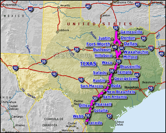
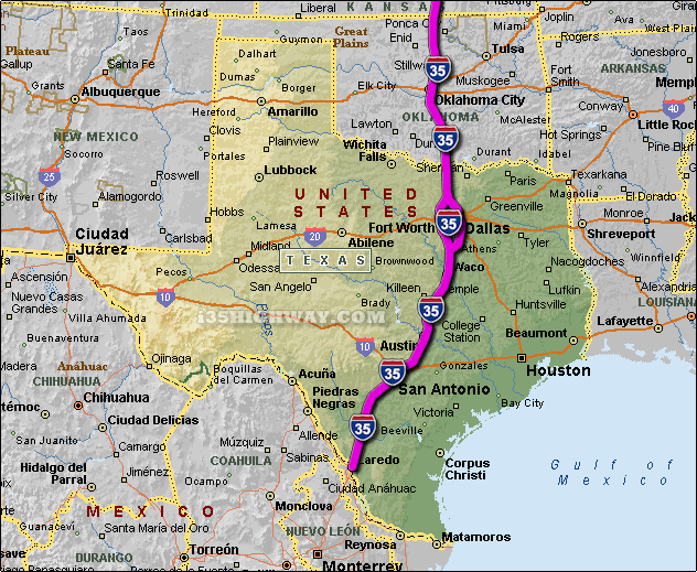
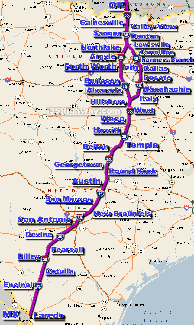
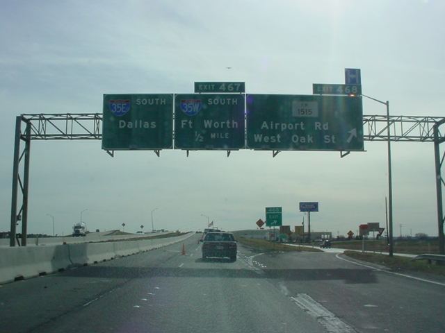
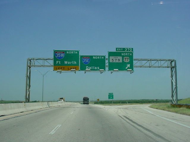
Interstate 35 (abbreviated I-35 or IH-35) in Texas is a major north–south Interstate Highway running from Laredo near the United States-Mexico border to the Red River north of Gainesville where it crosses into Oklahoma. Along its route, it passes through the cities of San Antonio, Austin, and Waco before it splits into two auxiliary routes just north of Hillsboro. Interstate 35E heads northeast where it passes through Dallas. Interstate 35W turns northwest to run through Fort Worth. The two branches meet up in Denton to again form Interstate 35, where it continues to the Oklahoma border. The exit numbers for Interstate 35E maintain the sequence of exit numbers from the southern segment of Interstate 35, and the northern segment of Interstate 35 follows on from the sequence of exit numbers from Interstate 35E. Interstate 35W maintains its own sequence of exit numbers.
Contents
- Laredo and South Texas
- San Antonio
- Austin
- Waco and Central Texas
- My35 Expansion Project
- Denton and North Texas
- Central Texas
- North Texas
- Auxiliary routes
- Miscellanea
- References
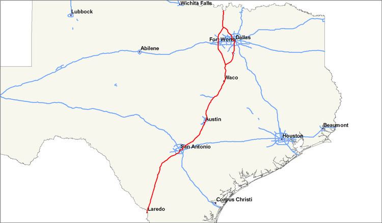
In Texas, Interstate 35 runs for just over 407 miles (655 km), which does not include either the 85-mile (137-km) segment of Interstate 35W or the 97-mile (156-km) segment of Interstate 35E. Texas contains more miles of the overall length of Interstate 35 than any other state, almost one-third of the entire length.
The Interstate is currently undergoing an extensive renovation and expansion project, known as 'My35.' The project includes work on portions of the interstate from Dallas south to Laredo.
Laredo and South Texas
In Laredo, Interstate 35 is between 6 and 8 main lanes in each direction, dropping to 4 near mile marker 13. After running concurrently with US 83 for 20 miles (32 km), the highway continues north-northeast across the South Texas Plains. The highway passes through the towns of Cotulla, Dilley, Pearsall, Devine, and Lytle before reaching San Antonio.
San Antonio
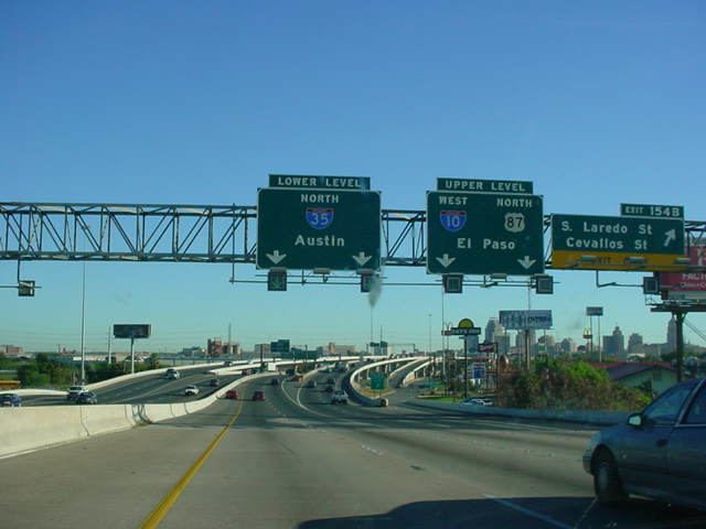
In San Antonio, I-35 is listed as the PanAm Expressway. It starts out as four lanes from the south until it reaches the Poteet-Jourdanton Freeway, expanding to six to eight mainlanes of travel. Its southern point begins in the southwest corner of town and travels northeast, crossing Interstate 410 near its southwest point. At the southwest corner of Downtown, it reaches an intersection with Interstate 10, United States Route 87 and United States Route 90. US 90 continues east and west from this junction, while I-10 westbound/U.S. 87 northbound joins with I-35 northbound along the western side of Downtown. In this section, it splits lanes to form two levels, a lower one for local traffic and a higher one for express traffic. They briefly rejoin near the northwest corner of Downtown to allow I-10/U.S. 87 to split off and go northwest.
I-35 continues, resplitting lanes again as it curves around the northwest corner of Downtown and turns east. It rejoins the lanes as it goes through an intersection at the northeast corner of Downtown, where Interstate 37's northern terminus is located, while United States Highway 281 will continue on the north–south freeway. I-35 continues east for a few miles until it begins to curve back to the northeast. It merges with I-410 on its eastern north–south leg from its northbound direction in a triangular interchange and continues north concurrently from there. A couple miles later, I-410 will split off onto its northern west–east leg, while I-35 resumes its north-northeast course past the northeast corner of the city.
Trucks are restricted from travel in the far left lane of I-35 in either direction throughout the San Antonio area. The restriction covers Bexar, Guadalupe, and Comal Counties.
Austin
In Austin, Interstate 35 is named Interregional Highway. Through most of the greater Austin area, I-35 is three to four lanes in each direction, dropping to three lanes north of Williamson County. It forms the eastern boundary of Downtown Austin and also passes through the eastern side of the University of Texas campus. I-35 is co-located with U.S. Highway 290 through central Austin.
Trucks are restricted from travel in the far left lane of I-35 in either direction throughout the Austin area. The restriction covers Hays and Travis counties and most of Williamson county and ends north of Jarrell, Texas where I-35 is reduced to three lanes in each direction .
I-35 is split into two decks between Martin Luther King Boulevard and Airport Boulevard, north of Downtown Austin. Both the upper and lower decks are signed as I-35 and US 290, and they use a common set of exit numbers, with some exit numbers duplicated between the two decks. The upper deck lanes are express lanes, with no on- or off-ramps. Drivers wishing to exit between Martin Luther King Boulevard and Airport Boulevard must use the lower deck.
The I-35 corridor between San Antonio and Austin is considered one of the most congested stretches of highway in the Interstate System. Much of this traffic is due to I-35 being considered one of the primary NAFTA corridors. Efforts to alleviate the congestion include State Highway 130, which forms an I-35 bypass loop to the east of Austin. Many local and regional governance organizations have on-going studies on other methods to improve mobility on I-35, which include such features as commuter rail lines and additional managed lanes.
On March 26, 2015, an overpass bridge beam fell in Salado, Texas, killing one person.
Waco and Central Texas
In Waco, Interstate 35 is known as the Jack Kultgen Freeway. I-35 has six to eight lanes through the city of Waco. It passes just to the west of the Baylor University campus and crosses the Brazos River adjacent to McLane Stadium, the new home of Baylor Bears football. Beginning in Waco and continuing up until just before the I-35E/I-35W split north of Hillsboro, I-35 is co-located with U.S. Highway 77.
'My35' Expansion Project
Interstate 35 through Central Texas is undergoing major expansion and renovation. The project is known as 'Main Street Texas', which is part of the larger scale 'My35' expansion plan. The 'Main Street' project primarily focuses on expanding the number of main lanes from four to six through McLennan and Bell counties. It also calls for complete replacement of the main lane bridges over the Brazos River, and extensive renovations to frontage roads and interchanges throughout the corridor. Funding for the project has been secured, with the exception of the portion of freeway to be renovated through the Downtown Waco area. $280 million in funding has yet to be secured for that section of the project.
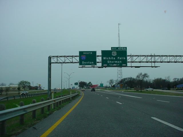
Denton and North Texas
Just southwest of Denton, Interstate 35W and Interstate 35E join to reform Interstate 35, which then continues north to the Oklahoma border. The exit numbers on I-35 continue on from the last exit of Interstate 35E.
Just north of Denton, U.S. Highway 77 is co-located with Interstate 35 through to the Oklahoma border, although it is not signed as such.
Central Texas
The right-of-way for the future Interstate 35 in Austin began being purchased in 1946, running along the so-called "inter-regional highway" (named for the precursor to the current Interstate Highway System). The formal opening of Interstate 35 in Austin took place in 1962. The alignment was chosen to line up with U.S. Highway 81 and with East Avenue, which formed the eastern boundary of Austin. US 81 has since been truncated and does not extend to Austin, and East Avenue today forms part of the frontage road for I-35 through downtown Austin.
In 1975, a 2-mile (3.2 km) set of elevated express lanes were added to I-35 between 15th Street and Airport Boulevard. The reason double-decking was used is because the highway is bounded in the area by the University of Texas campus on the west and by the Mount Calvary Cemetery on the east, restricting the available right-of-way. The lower deck kept its original configuration, which featured short on- and off-ramps with limited visibility. In 2000, some off-ramps on the lower deck were removed, in response to the already dangerous conditions becoming more so as traffic levels on the road increased. Interstate 35 in general and the double-decked section in particular have been viewed as a social dividing line between the central Austin and U.T. communities and the more economically depressed East Austin neighborhoods.
Interstate 35 at one time had one of the few at-grade railroad crossings in the Interstate Highway System. The crossing was removed during the 1970s.
North Texas
Construction on Interstate 35 in the DFW region began around 1960 with the upgrading of U.S. 77 to Interstate standards between Dallas and Denton. By 1965, Interstate 35 was complete from Dallas to the Oklahoma border, and by 1967 it was complete from both Dallas and Fort Worth southward to Austin. The remaining segment of Interstate 35W from Fort Worth to Denton was not completed until 1969.
Auxiliary routes
I-35 has three auxiliary routes in Texas: