
Type Highway | Length 2,834 km | |
 | ||
Route number(s) National Highway 1 (Darwin – Daly Waters; future route A1) National Highway 87 (Daly Waters – NT/SA border; future route A87) National Highway A87 (NT/SA border – Port Augusta) Major settlements Katherine, Daly Waters, Tennant Creek, Alice Springs, Coober Pedy | ||
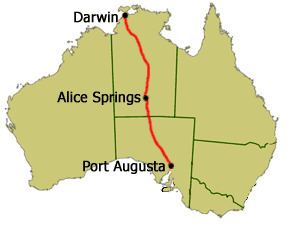
Stuart Highway is one of Australia's major highways. It runs from Darwin, Northern Territory, in the north, via Tennant Creek and Alice Springs, to Port Augusta, South Australia, in the south – a distance of 2,834 km (1,761 mi). Its northern and southern extremities are segments of Australia's Highway 1. The principal north-south route through the central interior of mainland Australia, the highway is often referred to simply as "The Track".
Contents
- Map of Stuart Hwy Australia
- Target 300km h in a fpv gt f falcon on the stuart highway nt
- Route description
- Northern Territory
- South Australia
- Background
- Highway planning and construction
- Speed limits
- Cannonball Run
- World Solar Challenge
- References
Map of Stuart Hwy, Australia
The highway is named after Scottish explorer John McDouall Stuart, who was the first European to cross Australia from south to north. The highway approximates the route Stuart took.
Target 300km h in a fpv gt f falcon on the stuart highway nt
Route description
Stuart Highway runs from Darwin, Northern Territory, in the north, via Tennant Creek and Alice Springs, to Port Augusta, South Australia, in the south – a distance of 2,834 km (1,761 mi).
The Royal Flying Doctor Service uses the highway as an emergency landing strip and sections of the highway are signed to that effect. These sections of highway have been specially selected and prepared for the landing of aircraft which only takes place after the piece of road has been closed by the police.
Northern Territory
The Northern Territory section of the Stuart Highway starts from the edge of the Darwin Central Business District at Daly Street and continues as a dual-carriageway to the Arnhem Highway in Howard Springs. The highway continues 317 km (197 mi) south passing the Kakadu Highway to the Victoria Highway at Katherine. The route number changes from National Highway 1 to National Highway 87. The highway then continues 673 km (418 mi) south passing the Roper Highway, the Carpentaria Highway and the Buchanan Highway to the Barkly Highway at Tennant Creek. The highway continues 508 km (316 mi) south into Alice Springs passing the Plenty Highway. It passes through the Macdonnell Ranges and finally crosses the South Australia/Northern Territory border south of Kulgera. The highway was only fully sealed in the mid-1980s as part of Australia's bicentenary roadworks programme. There are no police patrolling the majority of this remote highway and until the end of 2006 there was no speed limit outside towns and other built-up areas on the Northern Territory part. The bulk of the Northern Territory's population not living in Darwin lies along its track.
South Australia
At the Northern Territory/South Australia border the route number changes from to National Highway A87. The Stuart Highway passes through the Far North region to Port Augusta. The highway passes through the Woomera Prohibited Area where travellers may not leave the road. The highway continues south-east towards Adelaide.
There are petrol and other facilities (meals, toilets, etc.) available at reasonable intervals (usually around 200 km (120 mi)) and more frequent rest stops. Some of the rest stops are located at scenic points with information boards, but others are little more than a picnic table and a rubbish bin in the middle of nowhere.
Background
John McDouall Stuart led the first successful expedition to traverse the Australian mainland from south to north and return, through the centre of the continent, in 1861–1862. In 1871-72 the Australian Overland Telegraph Line was constructed along Stuart's route. The principal road from Port Augusta to Darwin was also established on a similar route.
A track developed along the route of the telegraph, and by 1888 the road between Adelaide and Alice Springs was well known. Several wells along the route provided water, although these could run dry or be contaminated by dead animals, resulting in sections as long as 144 miles (232 km) without water.
The route was traversed by motor vehicles in the 1920s. While passable, sections of the road could be sandy, boggy, washed away in the winter, or rugged with boulders. Several creek crossings were required, though few were difficult.
Highway planning and construction
With the onset on World War II, supply roads leading to the north of the country were considered vital by the federal government. This lead to the construction of Stuart Highway, as well as the connecting Barkly and Eyre highways. Over 960 kilometres of the Stuart Highway, from Tennant Creek to Darwin, was upgraded from an often impassable track to an all-weather sealed highway that could cope with heavy military traffic.
Speed limits
There was no absolute speed limit in the Northern Territory before 1 January 2007 but maximum speed limits are now posted on some road sections. Drivers, previously, were simply required to drive at a safe speed to suit the conditions. Thus, the Northern Territory section of the Stuart Highway had no speed limits at all. The Northern Territory traffic laws were updated from 1 January 2007 to be similar to the rest of Australia. This included placing a speed limit on all roads (130 km/h or 81 mph on major highways such as the Stuart Highway) and significantly increasing penalties for speeding.
The South Australian Section is signposted as 110 km/h (68 mph) outside built-up regions, between Port Augusta and the Northern Territory border.
In October 2013 the NT Government announced a trial period of reverting to an open speed limit on the 200 km (120 mi) stretch between Alice Springs and Barrow Creek, beginning 1 February 2014. In September 2015, following the conclusion of the trial, a 276 km (171 mi) stretch of the highway had its speed limits permamently derestricted.
As of November 2016, a speed limit has been reinstated, with the maximum speed now being 130 km/h (81 mph)
Cannonball Run
In 1994 the first and only Cannonball Run in Australia ran from Darwin to Yulara and back again. Based on similar events in the United States, this event ended in tragedy when an out of control Ferrari F40 crashed into a checkpoint south of Alice Springs, resulting in the death of the two event officials manning the checkpoint as well as the two competitors. The remainder of the race had a 180 km/h (112 mph) speed limit imposed to prevent further accidents.
World Solar Challenge
Stuart Highway is the highway taken in the World Solar Challenge. The 2013 Bridgestone World Solar Challenge will welcome 42 teams from 24 countries to Australia to take part in what is the world’s largest solar electric vehicle event. The World Solar Challenge starts in Darwin in the Northern Territory and travels the Stuart Highway to Port Augusta and then via Highway 1 to the finish in the City of Adelaide in South Australia – 3000 km. The elite Challenger class is conducted in a single stage from Darwin to Adelaide. Once the teams have left Darwin they must travel as far as they can until 5pm in the afternoon where they make camp in the desert wherever they happen to be. Other classes have different requirements, but all teams must be fully self-sufficient.
During the journey there are 7 mandatory check points where observers are changed and team managers may update themselves with the latest information on the weather and their own position in the field. Here teams may perform the most basic of maintenance only – checking and maintenance of tyre pressure and cleaning of debris from the vehicle.
There are also undisclosed check points which may be imposed by the event officials to ensure regulatory compliance.