
Type Highway Formerroute number State Route 1 | Opened 1954 Length 17 km | |
 | ||
Via | ||
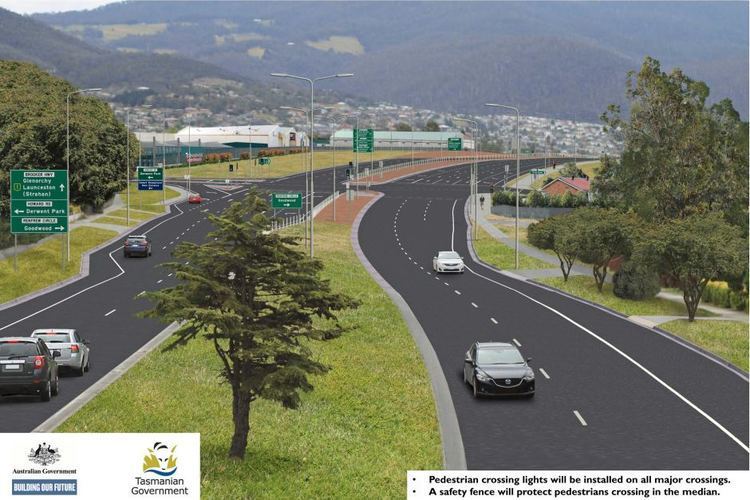
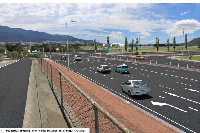
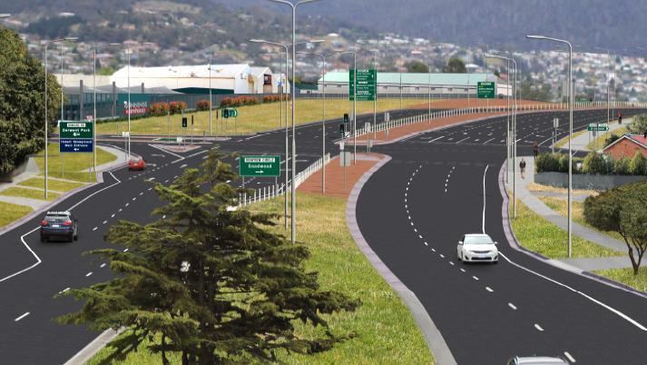
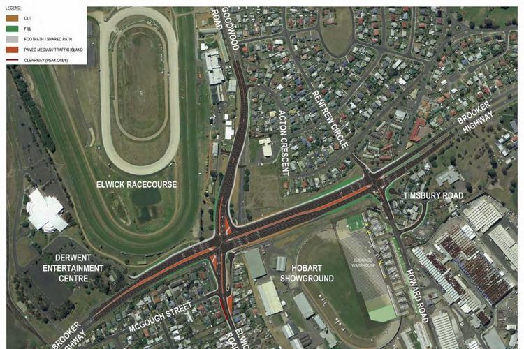
During the brooker highway upgrade 2016
The Brooker Highway (sometimes referred to as the Northern Outlet) is a highway in the State of Tasmania, Australia. As one of Hobart's 3 major radials, the highway connects traffic from the Hobart city centre with the northern suburbs and is the major road connection to the cities and towns of Northern Tasmania. With an AADT of 48,000, the highway is one of the busiest in Tasmania. The Brooker Highway has recently been declared part of the National Highway.
Contents
- During the brooker highway upgrade 2016
- Pedestrian killed on brooker highway
- History
- Lighting
- 2010 Emergency Landing Incident
- Future
- Route description
- References
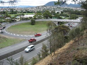
The Brooker Highway runs approximately 17 km (11 mi) north from the CBD, through the northern suburbs of Hobart, and through the City of Glenorchy, bypassing commercial and industrial centres along the original Main Road. It is primarily a four lane (dual-carriageway) highway, and apart from the Domain Highway junction, only the northern sections of the highway have grade separated junctions. The remainder of the junctions are regulated by traffic light and roundabout intersections.
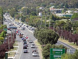
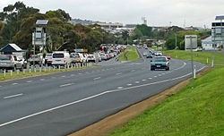
While the highway is substantially less congested than in other states during peak hours, it is more congested off-peak than roads in Queensland, Western Australia, and almost as congested as those in New South Wales. It is thus a busy road by any Australian standard. The Brooker Highway is currently below the acceptable levels of service and congestion issues are expected to worsen significantly over the next 20 years with the Highway already approaching its designed capacity. A current proposal to convert the Southern Railway Line for use as a Light rail system has the potential to alleviate the Brooker Highway's traffic problems.
Pedestrian killed on brooker highway
History
The original Brooker Avenue was constructed in 1954 as a 2 lane road from the end of Liverpool Street to Elwick Road. In 1965, the Hobart Area Transportation Study was released and entailed large development plans for the Brooker Highway. By 1968 the road had been duplicated and works reached Berriedale. In 1977 the highway was further extended, taking the road to the Claremont Link Road. By 1983 the highway that stands today was complete through to Granton and the Bridgewater bridge. The Brooker Highway was built as a replacement to the original Midland Highway route between Hobart city and Granton, which passed along Elizabeth Street, New Town Road and Main Road, through the built up areas of New Town, Moonah, Glenorchy, Rosetta, Montrose, Claremont and Berriedale. This was the first major highway construction in the Hobart City region, and was named the Brooker Highway, after the Minister for Transport at the time of the conception of the project, Edward Brooker (between Davey Street and Cleary's Gates at the top of the ridge, the highway is also known as "Brooker Avenue").
Lighting
In April 2007, the Department of Infrastructure, Energy and Resources announced plans to replace the sub-standard rusted light poles between Risdon Road and Clearys Gates Road. These are over 40 years old and were the first lights on the Highway, which sparked some concern from the Hobart City Council. They argue that the light poles are in good condition and are a significant feature of the Brooker Highway entrance to Hobart. While the Hobart City Council supports the replacement, they have written to Infrastructure Minister Jim Cox asking him to consider retaining the ornate arms on modern pole bases.
2010 Emergency Landing Incident
On 4 April 2010 18-year-old pilot Patrick Humphries made world headlines by using the normally busy highway as an emergency landing strip after running out of fuel. Humphries was unhurt from the accident and no vehicles were involved in the incident.
Future
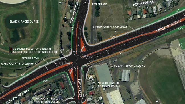
The Department of Infrastructure, Energy and Resources proposes to re-align the Elwick Road and Goodwood Road exits, reducing confusion and the number of traffic lights. The nearby Goodwood roundabout will also be replaced with traffic lights. The Tasmanian Government has also revealed they are currently planning to upgrade the interchange at the Domain Highway to improve access and travel flows for passenger and freight. This includes a capacity expansion to 6 lanes from the Domain Highway to Risdon Road.
Recently the government came under pressure from the community to improve pedestrian access over the highway at Goodwood and eliminate the stairs primarily for the benefit of the elderly and handicapped.
Route description
The highway starts in the Hobart CBD at the junction with Eastern Outlet (A3, Tasman Highway), Davey Street (A6) and Macquarie Street (A6). The Tasman Highway heads east over the Tasman Bridge, past the Airport and eventually leads to the east coast of the state, while Davey Street leads towards the Southern Outlet (A6), which in turn heads south towards Kingston and Huonville (Davey and Macquarie are one-way streets - Davey Street flows south-west, and Macquarie Street flows north-east through the CBD).
Apart from the connection to Davey and Macquarie Streets, the major intersection with streets in the CBD is the three-lane roundabout at the north-east end of Liverpool Street. Because it was built in close proximity to the main railway station at the time, the roundabout was, and continues to be, called the "Railway Roundabout". The sunken garden in the centre of the roundabout functions as a pedestrian thoroughfare, with under-road tunnels connecting to the two sides of Liverpool Street, the original site of the railway station to the north-east, and to the Domain and the suburb of The Glebe to the north-west. The roundabout was originally just an un-controlled intersection, but with the gradual increase in traffic, particularly from the eastern shore of the Derwent, it was often in grid-lock at peak travel times. Traffic lights were introduced and alleviated the situation, and later construction of the direct links from the Tasman Bridge to Davey and Macquarie Streets further relieved the pressure. Other streets from the CBD provide access to the highway, but for much of its length to the city boundary at Risdon Road it is limited access road.
Through the City of Glenorchy the highway has large multi-lane intersections, at Risdon Road, Elwick Road and Derwent Park Road. The highway is in a reasonable condition for its age, and experiences congestion for only a few hours a day.
Trees line the middle nature strip for several kilometres, and fencing prevents pedestrian access at various points. The Highway makes its way past The Domain, Cornelian Bay Hockey Grounds, Rugby Park, The Royal Hobart Showgrounds, Tattersalls Park and the Derwent Entertainment Centre. At the northern end (at Granton) it connects to the Midland Highway (National Highway 1) (which heads north towards Launceston) and the Lyell Highway (A10) (which takes motorists towards the west coast).