
Length 52 km (32.3 mi) Highest elevation 1,121 m (3,678 ft) Elevation 1,121 m Peak Mount Bowen | Total islands great barrier reef Width 10 km (6 mi) Highest point Mount Bowen Area 399 km² Established 1932 | |
 | ||
Similar Wallaman Falls, Wet Tropics of Queensland, Fitzroy Island, Family Islands National, Brook Islands National | ||
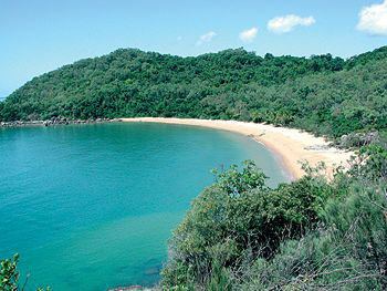
Zoe bay hinchinbrook island qld
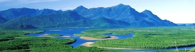
Hinchinbrook Island lies east of Cardwell and north of Lucinda, separated from the northern coast of Queensland, Australia by the narrow Hinchinbrook Channel. Hinchinbrook Island is part of the Great Barrier Reef Marine Park and wholly protected within the Hinchinbrook Island National Park, except for a small and abandoned resort. It is the largest island on the Great Barrier Reef. It is also the largest island national park in Australia.
Contents
- Zoe bay hinchinbrook island qld
- Hinchinbrook island thorsborne trail
- Natural heritage
- History
- Tourism
- Destinations and regulations
- Access
- Shipwreck
- References
Hinchinbrook island thorsborne trail
Natural heritage
Hinchinbrook Island is made up of late Palaeozoic igneous rocks. The main 16-kilometre-long (9.9-mile) pluton in the east of the island, the Hinchinbrook Granite, is composed of various hypersolvus granites and intrudes volcanics, granodiorites, and granites. The island and coastal ranges are thought to have been thrust up as blocks with subsidence between them to form the coastal plain with the summit level of the island being an older dissected surface that has been uplifted to approximately 1 kilometre (0.62 miles) or more above sea level. The Hinchinbrook Channel that separates the island from the mainland is considered to be fault controlled.
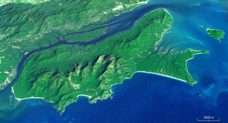
Since the last Ice Age 18,000 years ago sea level has risen. Once there was a significant rugged coastal range, now there is Hinchinbrook Island. To the west is the mangrove-fringed Hinchinbrook Channel with 164 km2 of robust mangrove estuaries. The channel is the valley of the Herbert River flooded following the last glacial period. The island is only separated from the mainland at times of high sea-level such as the present and is thought to have had dry land connections to the mainland for most of the past few million years. Further west is the Cardwell Range Escarpment rainforest. East of Hinchinbrook Island lies the Coral Sea, Great Barrier Reef Lagoon and Great Barrier Reef.
To the north of Hinchinbrook Island, Rockingham Bay hosts densely vegetated continental islands e.g. Garden Island, Goold Island, Brook Islands Group, Family Island Group, Bedarra Island and Dunk Island east of Mission Beach. South of Hinchinbrook Island, the Cardwell Range gives way to the Herbert River floodplain and delta.
Missionary Bay is at the northern end of Hinchinbrook Island National Park. Natural features of this biodiverse area include 50 km2 of dense mangrove communities lining the shoreline. Many botanists believe the mangrove forests along the island's western coast are the most diverse in the country. 31 different species of mangrove has been identified. A shallow subhorizontal tidal zone has extensive offshore sea grass beds grazed by dugong. The beach stone-curlew thrives on the island, unlike on mainland beaches because vehicles are banned.
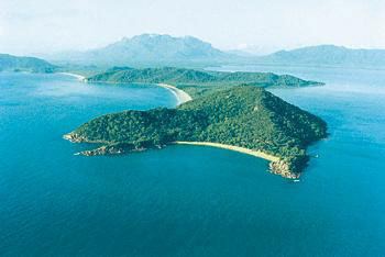
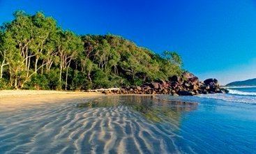
The eastern coastline of Hinchinbrook Island is punctuated with headland outcrops, incised drainage conduits, forest, secluded sandy pocket beaches and sand dunes. Mangroves are in proximity to freshwater streams. At Ramsay Bay on the northeast coast, a transgressive dune barrier or tombolo links Cape Sandwich, a granite outlier at the northeastern tip of the island, to the main part of the island. The barrier is widest in the north with a maximum width of about one kilometre (0.62 miles) and narrows to the south to a width of about 100 to 200 metres (330 to 660 feet). The barrier, which consists mainly of aeolian sands, extends more than 30 metres (98 feet) below the present sea level in places. It is thought to have been formed in two major episodes, the older dunes being partly drowned during an early Holocene marine transgression (9500-6000 C-14 years BP) with the later generation of dunes forming within the last 900 C-14 years BP.
Hinchinbrook Island is described as a "wilderness area," wild and rugged with soaring mountainous peaks. Hinchinbrook Island's highest mountain is Mount Bowen, 1,121 metres (3,678 feet) above sea level. Terrestrial vegetation types include thick shrubs, heath, bushland and forest. The island habitat provides refuge for numerous endangered species, both flora and fauna such as the giant tree frog.
The local climate is tropical, warm to mildly cool and dry during the winter months. The summer monsoon wet is warm to hot and humid, coinciding with the tropical cyclone season. The island has no reefs in the waters surrounding it, most likely due to fresh water runoff from the island.
History
Hinchinbrook Island was inhabited by the Bandjin people, along a western coastal strip. Shell middens and fish traps are evidence of their activities. Fish were an important source of food for Aboriginal people living in the area. The Bandjin fish trap rock formations exploited the cyclic tidal regime, not only capturing fish, but also holding their catch alive for days. At times, many fish would be caught in the traps. These fish would not be killed nor eaten, instead they were left for the birds. To this day fish are still captured by these traps feeding the local birds.
In 1770 James Cook and his crew on HMS Endeavour sailed past at some distance east of Hinchinbrook Island. Hinchinbrook Island was named on the 19 May 1819 by Lieutenant Phillip Parker King RN (1791–1856). It is named after Hinchingbrooke House, in Huntingdon, as John Montagu, 4th Earl of Sandwich was First Lord of the Admiralty, and the naming of Hinchinbrook Island, Brampton Island and Montague Island in the South Sandwich Islands are evidence of Cook's thanks to the 4th Earl. King was a naval officer, hydrographer and company manager who explored the northeastern coast of Australia on the HM Colonial Cutter Mermaid.
In the following decades Europeans settled on Hinchinbrook Island. Their main activities were fishing, farming and mining. In 1932 Hinchinbrook Island was declared a national park. In 1942, a US B24 Liberator bomber crashed into a mountain on the island, killing all 12 people on board. After World War II, commercial crocodile hunting in the area nearly reduced numbers to the point of extinction by the 1960s.
The 2008 movie Nim's Island was partly filmed on the island.
Tourism
The island had a single provider of accommodation called the Hinchinbrook Island Wilderness Lodge, however it closed in 2010 as a result of financial difficulties caused by the global financial crisis. Several months later it was struck by Cyclone Yasi. The infrastructure has since been looted and left to decay. It is located on the north-eastern corner of the island at Cape Richards.
Destinations and regulations
Hinchinbrook Island, Hinchinbrook Channel and the coastal plain south to the Herbert River Delta(Lucinda) is a unique biogeographical region.
Along the east coast of the island is the 32 km (20 mi) long Thorsborne Trail. The trail was named in honour of environmental activists Arthur and Margaret Thorsborne.
Marine nature based activities include; sightseeing cruises, sailing, outrigger canoeing, swimming, snorkelling and scuba diving. Sea kayaking is possible east of Hinchinbrook Island; west, the island is known saltwater crocodile habitat.
Hinchinbrook Island camping is by permit only. Visitor numbers to the island is restricted. The aim is to preserve the islands biodiversity and limit environmental degradation. Open fires are not permitted.
Access
The Bruce Highway connects Townsville, Lucinda, Cardwell, and Cairns. Locally the Bruce Highway within Cardwell town limits is known as Victoria Street. Regular scheduled coach services operate from the transit zone in Brasenose Street, Cardwell and Townsvillee Road in Ingham. Hinchinbrook resorts and Helloworld in Ingham run bus shuttles to Townsville and return to Lucinda for people hiking the Thorsborne trail. Queensland Rail has regular services operating, transiting from the Cardwell Rail Station in Roma Street.
Shipwreck
In 2011, the shipwreck of a thirty-metre (98-foot) longboat was discovered on the shores of Ramsay Bay by a fisherman. It is thought that the wreck is about 130 years old and was uncovered by Cyclone Yasi.