
Length 130 km (81 mi) Countries Austria and Italy Country Austria | Elevation 3,798 m (12,461 ft) Width 50 km (31 mi) Orogeny Alps | |
 | ||
Mountains Similar Grossglockner, Alps, Großvenediger, Kitzsteinhorn, Eastern Alps | ||
Beautiful nature high tauern national park austria nationalpark hohe tauern
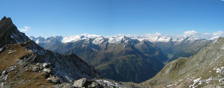
The High Tauern (pl.; German: Hohe Tauern, Italian: Alti Tauri) are a mountain range on the main chain of the Central Eastern Alps, comprising the highest peaks east of the Brenner Pass. The crest forms the southern border of the Austrian state of Salzburg with Carinthia and East Tyrol, while a small part in the southwest belongs to the Italian province of South Tyrol. The range includes Austria's highest mountain, the Grossglockner at 3,798 metres (12,461 ft) above the Adriatic.
Contents
- Beautiful nature high tauern national park austria nationalpark hohe tauern
- Map of Hohe Tauern 5730 Mittersill Austria
- GeographyEdit
- High Tauern National ParkEdit
- PeaksEdit
- Tunnels and passesEdit
- References
Map of Hohe Tauern, 5730 Mittersill, Austria
In the east, the range is adjoined by the Lower Tauern. For the etymology of the name, see Tauern.
GeographyEdit
According to the Alpine Club classification of the Eastern Alps, the range is bounded by the Salzach valley to the north (separating it from the Kitzbühel Alps), the Mur valley and the Murtörl Pass to the east (separating it from the Lower Tauern), the Drava valley to the south (separating it from the Southern Limestone Alps), and the Birnlücke Pass to the west (separating it from the Zillertal Alps).
Its most important subgroups along the Alpine crest are (from West to East):
The eastern end of the High Tauern is formed by the Hafner massif of the Ankogel Group, which includes the easternmost three-thousander peaks in the Alpine chain.
Further parts of the High Tauern south of the main crest of the Alps are (from West to East):
High Tauern National ParkEdit
Along 100 kilometres (62 mi) of the main chain stretches the High Tauern National Park (Nationalpark Hohe Tauern), to which the Austrian Alpine Club as freeholder and the three states of Carinthia, Salzburg and Tyrol have contributed territory. With an area of about 1,834 square kilometres (708 sq mi), it is by far the largest of Austria's seven national parks as well as the largest nature reserve in the Alps. It is divided into a core zone including the Grossglockner and Grossvenediger massifs, with complete prohibition of agricultural use, and a fringe zone used for forestry and alpine-meadow farming. Five special nature sanctuaries are protected from any human disturbance.
The park of the IUCN II category comprises the Pasterze and numerous further glaciers, the Krimml Waterfalls, several glacial valleys and alluvial fans, as well as extended tundra areas and forests. Among the flora of the Alps, especially Swiss Pines grow along the tree line; above subshrub, mainly alpenrose but also the endemic saxifraga rudolphiana, up to nival level at about 2,800 m (9,200 ft). The fauna includes chamois, Alpine ibex and red deer, as well as griffon vulture and the golden eagle. The formerly extinct bearded vulture and the Alpine marmot have been successfully reintroduced.
The park was established according to a 1971 declaration signed by the participating states at Heiligenblut, it nevertheless took until 1981, when the first parts around Großglockner and Hochschober in Carinthia were put under protection. The adjacent area in Salzburg followed two years later, and Tyrol finally joined in 1992. Tourism only increased marginally since the creation of the national park, but has become less harmful to the environment. A particular emphasis is put on environmental protection and the maintenance of traditional ways of life in the Alps.
PeaksEdit
The main peaks of the High Tauern are:
Tunnels and passesEdit
The High Tauern are crossed by three tunnels:
The best-known mountain pass road of the High Tauern is the scenic Grossglockner High Alpine Road inaugurated in 1935, including a tunnel at an elevation of 2,505 metres (8,219 ft) under the Hochtor Pass (2,573 metres (8,442 ft)). East of it, the Katschberg Pass (1,641 metres (5,384 ft)) on B 99 Katschberg Straße highway parallel to the Katschberg Tunnel links Sankt Michael and Rennweg. Another road crosses the Staller Sattel between Sankt Jakob in Defereggen and Rasen-Antholz at 2,052 metres (6,732 ft).
Beside there are numerous bridle and foot paths, in part used since ancient times: