
Parent range Alps | Elevation 3,510 m (11,520 ft) Highest point Hochfeiler Country Italy | |
 | ||
Mountains | ||
Farming simulator 17 zillertal alps
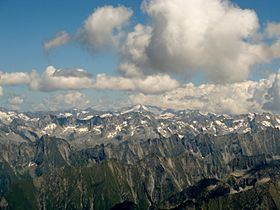
The Zillertal Alps (Italian: Alpi Aurine; German: Zillertaler Alpen) are a mountain range of the Central Eastern Alps on the border of Austria and Italy.
Contents
- Farming simulator 17 zillertal alps
- Map of Zillertal Alps 39030 Ahrntal Province of Bolzano South Tyrol Italy
- Hiking the zillertal alps in austria
- NameEdit
- GeographyEdit
- Sub groupsEdit
- PeaksEdit
- PassesEdit
- References
Map of Zillertal Alps, 39030 Ahrntal, Province of Bolzano - South Tyrol, Italy
Hiking the zillertal alps in austria
NameEdit
The range is named after the Zillertal (Ziller river valley) on its north.
GeographyEdit
The range is bounded by the Tuxerjoch mountain pass to the north (separating it from the Tux Alps); the Birnlücke - Forcella del Picco pass to the east (separating it from the Hohe Tauern); the Eisack and its tributary the Rienz to the south (separating it from the Southern Limestone Alps); and the Brenner Pass to the west (separating it from the Stubai Alps).
Sub-groupsEdit
The Zillertal Alps are divided into the following sub-groups:
This is further sub-divided as follows: Hauptkamm, Hochstellerkamm, Greinerkamm, Mörchen and Igentkamm, Floitenkamm, Ahornkamm, Riblerkamm, Magnerkamm.
This is further subdivided as follows: Reichenspitzkamm, Gerloskamm, Schönachkamm, Wimmerkamm, Schwarzachkamm, Zillerkamm, Klockerkarstock.
This is further subdivided as follows: Kreuzspitzkamm, Plattspitzkamm, Wurmaulkamm, Grubbachkamm, Mühlwalder Kamm.
PeaksEdit
The main peaks of the Zillertal Alps are:
PassesEdit
The main mountain passes of the Zillertal Alps are:
References
Zillertal Alps Wikipedia(Text) CC BY-SA