
Isolation 7.39 km → Alplesspitze First ascent 1861 | Elevation 3,098 m Prominence 490 m | |
 | ||
Normal route Southern ascent from the Glauret (I) Similar Großvenediger, Zunig, Hoher Eichham, Kreuzspitze, Rötspitze | ||
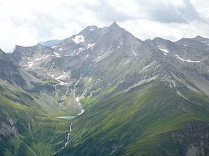
The Lasörling is a mountain, 3,098 m (AA), and the highest summit in the eponymous range that stretches from the Virgental to the Defereggental valleys opposite the Großvenediger. Occasionally the mountain is also called the "Großer Lasörling" ("Great Lasörling) because it has a double summit - its southeast top reaching a height of 3,055 m (AA). The main top was formerly also called the Bergerspitze, and the southeast top the Musspitze or Virgen Lasörling.
Contents
Map of Las%C3%B6rling, 9972, Austria
The easiest ascent of the mountain begins in the valley of Virgental and runs through the Mullitztal valley to the Lasörling Hut. This climb is glacier-free, but requires sure-footedness and has climbing sections rated at grade I.
Name
The name "Lasörling" refers to the appearance of the mountain: Arl(ing) is an old German word for ploughshare or plough and stems from the Old Germanic word or loanword from the Slovene word oralnik. Around 1531, the mountain was still recorded with the Slovenian suffix -nik as "Lasornik". For the year 1670 it is written as "Lasernik". The syllable -nik was replaced in later usage by "-ling". The prefix "Las-" goes back to the (Old) Slovenian word for clearance (German: Gereute), as in other words like Lasnitzen, Laßnitz etc.
First ascent
The Lasörling was first climbed via the northern arête in 1861 by Carl von Sonklar after several attempts.
According to other sources the first climbers are unknown, but probably hunters. The first historically confirmed ascent was carryed out by H. v. Acken and his survey assistants in 1854 in the course of state survey work using the present normal route, the southern ascent from the Glauret. Carl Sonklar first crossed the east face on the descent (1861) and the northwestern arête (1864).
Routes to the summit
The most popular route up the Lasörling runs initially from the Lasörling Hut (2,350 m (AA)) heading northwest into the former mining area of Glauret. South of the summit the path branches off north and runs in zig-zags over piles of moraine to the Lasörlingscharte notch (2,950 m (AA)) and finally to the summit. The 748 metres of height can be climbed in about three hours.
The shortest way from the Virgental valley to the summit runs through the Lasnitzental valley in a southern and later southeasterly direction to the western arête. After a short and easy climb on the ridge in an easterly direction the route arrives at the Lasörlingscharte and joins the path from the Lasörling Hut.