
Elevation 2,962 m (9,718 ft) | Length 44 km (27 mi) | |
 | ||
Similar Alps, Villgratental, Rieserferner Group, Schober group, High Tauern | ||
The Villgraten Mountains (German: Villgratner Berge) or Deferegg Alps (Deferegger Alpen), also called the Defreggen Mountains (Defreggengebirge, archaically also with "ff") are a subgroup of the Austrian Central Alps within the Eastern Alps of Europe. Together with the Ankogel Group, the Goldberg Group, the Glockner Group, the Schober Group, the Kreuzeck Group, the Granatspitze Group, the Venediger Group and the Rieserferner Group, the Villgraten Mountains are part of the major mountain range, the High Tauern. Their highest summit is the Weiße Spitze with a height of 2,962 m (AA).
Contents
- Map of Deferegger Alpen 9961 Austria
- LocationEdit
- RangeEdit
- Highest summitEdit
- PeaksEdit
- ValleysEdit
- Neighbouring mountain groupsEdit
- HutsEdit
- References
Map of Deferegger Alpen, 9961, Austria
LocationEdit
The Villgraten Mountains lie mainly in Austria, in the state of Tyrol, with a smaller element in Italy in the province of South Tyrol, in the region of Trentino-South Tyrol. They are located in the south of the High Tauern. Lienz, the regional capital of East Tyrol, is on the eastern side of the mountain range. Olang in the Puster Valley is located on the western side. Their name comes from the Villgraten Valley (Villgratental), which runs up into the mountains from the south.
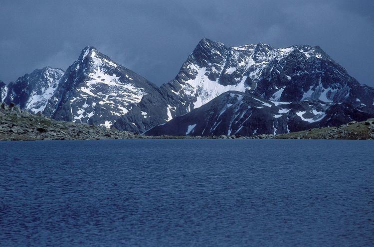
The Villgraten Mountains are a peaceful backwater in many respects. There are no spectacular mountain peaks nor any comprehensive access with cable cars and roads. By contrast, the mountain hiker and nature lover can still find peace and quiet and enjoy nature in these mountains. The range is well known for a host of picturesquely situated mountain lakes, its rich plant life and the still relatively intact alpine pastures (Almmähder). The eponymous Villgraten Valley and its neighbour, the Gsies Valley to the west, are a ski touring paradise in winter.
RangeEdit
The range was formally designated as the Villgraten Mountains (Villgratner Berge or Villgrater Berge) in the AVE, the Alpine Club classification of the Eastern Alps in 1984. This term is also used by the publisher, Bergverlag Rudolf Rother, the publishing house with the widest coverage of the Eastern Alps. On many maps, however, they are called the Defereggen Mountains (Defereggengebirge) or Gsies Mountains (Gsieser Berge).
The Defereggen valley is located on the northern edge of the mountain group. North of the valley is the Venediger Group. The Villgraten Valley, by contrast, is located entirely within the Villgraten Mountains. Consequently, the mountains are undoubtedly more logically named after this valley than after the Defereggental. In older classification systems of the Eastern Alps the Lasörling Group, north of the Defereggental, was counted as part of the Defereggen range. In earlier times the Defereggen valley would have been a suitable source of the name. Under the AVE, however, the Lasörling Group now belongs clearly to the Venediger Group.
Following the enforced annexation of South Tyrol after the First World War, the western part of the Villgraten Mountains ended up politically as part of Italy and was officially renamed the Monti di Casies. This was not a historically derived regional name, but a translation by Ettore Tolomei. German-speaking South Tyrolese frequently call them the Gsies Mountains (Gsieser Berge).
The term Villgraten Mountains is also historically and formally correct in referring to the entire mountain chain between the Hochstein east of Lienz and the Staller Saddle. Some maps use the name Defereggen Mountains (Defereggengebirge) for the eastern portion that lies within Austria, whilst labelling them the Gsieser Berge/Monti di Casies in the western portion that lies in Italy.
Highest summitEdit
In the centre of the group rise two summits of almost equal height (46°52′18″N 12°21′29″E and 46°52′34.86″N 12°20′39.96″E), called the Weiße Spitze and Rote Spitze ("White Peak" and "Red Peak"). The more easterly, with a height of 2,962 m (AA), is the highest point in the group. On that, all the maps and literature are agreed. However, the naming of the two summits is disputed. Whilst the majority of the Alpine literature, the official maps and the inhabitants of the southern Villgraten valleys call the higher, eastern summit the Weiße Spitze, and its lower, western, neighbour the Rote Spitze, it is referred to in the Defreggental, north of the mountains, and in one of the hiking books the other way around, thus naming the highest point as the Rote Spitze.
Because the sources do not agree on the naming of these peaks, the designation used by the Austrian Federal Office of Metrology and Surveying is generally preferred. They confirm that the eastern summit is called the Weiße Spitze with a height of 2,962 m (AA) as the highest peak in the group.
PeaksEdit
No peak in the Villgraten Mountains reaches the 3000 metre mark, but there are 20 summits higher than 2,800 m (AA) They are (sorted by height):
ValleysEdit
Four larger valleys runs from the south into Villgraten Mountains: the uninhabited Wilfernertal, that descends to the village of Thal in the municipality of Assling, the likewise unpopulated Kristein, the Villgraten valley with its municipalities of Außervillgraten and Innervillgraten and the Gsieser valley in South Tyrol with its villages of Pichl, St. Magdalena and St. Martin. The Villgraten Mountains are bounded in the north by the Defereggen valley, in the east by the Iseltal, in the southeast by the Lienzer Talboden, in the south by the Puster valley and in the west by the Antholz Valley. Their boundary with Rieserferner Group is formed by the Staller Saddle. Of note is the Gsieser Törl within the Villgraten Mountains which acts as the transition from the South Tyrolean Gsies valley (Gsieser Tal) to the East Tyrolean Defereggen valley (Defereggental), which after the First World War until the 1970s was used as a smuggler's route between Austria and Italy.
Neighbouring mountain groupsEdit
The Villgraten Mountains border on the following other mountain groups of the Alps:
HutsEdit
In the Villgraten Mountains there is an Alpine Club hut as well as several private huts and mountain cafes or (Jausenstationen):