
Governing body U.S. Forest Service Nearest city Amboy | Visitors 1,800,000 (in 2005) Established 1908 | |
 | ||
Area 1,321,506 acres (5,347.95 km) Management | ||
Government mineral springs guard station gifford pinchot national forest
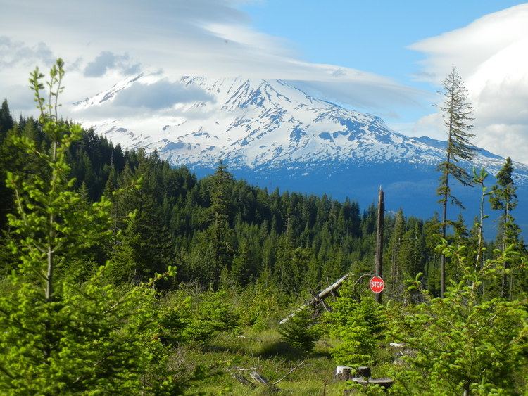
Gifford Pinchot National Forest is a National Forest located in southern Washington, USA, managed by the United States Forest Service. With an area of 1.32 million acres (5300 km2), it extends 116 km along the western slopes of Cascade Range from Mount Rainier National Park to the Columbia River. The forest straddles the crest of the South Cascades of Washington State, spread out over broad, old growth forests, high mountain meadows, several glaciers, and numerous volcanic peaks. The forest's highest point is at 12,276 ft. at the top of Mount Adams, the second tallest volcano in the state after Rainier. It includes the 110,000-acre (450 km2) Mount St. Helens National Volcanic Monument, established by Congress in 1982.
Contents
- Government mineral springs guard station gifford pinchot national forest
- Map of Gifford Pinchot National Forest Washington 98377 USA
- Iron creek campground gifford pinchot national forest washington campsite photos
- History
- Geography
- Major Rivers
- Major Lakes
- Congressional action
- National Monuments
- Wilderness Areas
- Points of Interest
- Forest Service management
- Fauna
- References
Map of Gifford Pinchot National Forest, Washington 98377, USA
Iron creek campground gifford pinchot national forest washington campsite photos
History
Gifford Pinchot National Forest is one of the older national forests in the United States. Included as part of the Mount Rainier Forest Reserve in 1897, the area was set aside as the Columbia National Forest in 1908. It was renamed the Gifford Pinchot National Forest in honor of Gifford Pinchot, on June 15, 1949. In 1985 the non-profit Gifford Pinchot Task Force formed to protect the area. People for over 6,000 years have made an impact in the ecology of the Gifford Pinchot National Forest. Native Americans hunted in high meadows below receding glaciers. The natives then began to manage the forest to meet their own needs. One method they used was to burn specific areas to help in the huckleberry production. About 338 spots more than 6,000 culturally modified trees were identified, of which 3,000 are protected now. Archaeological investigations on the forest continually find new information to this day about the past lifestyles of the Native Americans.
The forest was named after Gifford Pinchot, one of the leading figures in the creation of the national forest system of the United States. The forest is home to the Big Tree at the southern flank of Mt Adams, one of the world's largest Ponderosa Trees.
Geography
Gifford Pinchot National Forest is located in a mountainous region approximately between Mount St. Helens to the west, Mount Adams to the east, Mount Rainier National Park to the north, and the Columbia River to the south. This region of Southwest Washington is noted for its complex topography and volcanic geology. About 65 percent of the forest acreage is located in Skamania County. In descending order of land area the others are Lewis, Yakima, Cowlitz, and Klickitat. counties.
Major Rivers
The Pacific Northwest brings abundant rainfall to the Gifford Pinchot National Forest, feeding an extensive network of rivers. The forest has only one river currently designated as Wild and Scenic, the White Salmon River, fed from glaciers high on Mount Adams. The Gifford Pinchot National Forest recommends four rivers to be added to the Wild and Scenic System. They are the Lewis River, the Cispus River, the Clear Fork and the Muddy Fork of the Cowlitz River. There are an additional thirteen rivers in the forest being studied for consideration into the national Wild and Scenic River System.
The following listed are the major streams and rivers of the Gifford Pinchot National Forest. Many of these provide excellent fishing.
Major Lakes
The Gifford Pinchot National Forest includes many popular and secluded backcountry lakes. Most of the lakes offers excellent fishing. Goose Lake is known for the best fishing in the State of Washington.
The following table lists the major lakes of the Gifford Pinchot National Forest:
Congressional action
Congressional action since 1964 has established one national monument and seven wilderness areas in the Gifford Pinchot National Forest.
National Monuments
In August 26, 1982, congressional action established the Mount St. Helens National Volcanic Monument, after the cataclysmic eruption of Mount St. Helens in 1980.
Wilderness Areas
Congressional action since 1964 has established the following wilderness areas:
Points of Interest
The forest also offers the following special areas and points of interest:
Forest Service management
A 1993 Forest Service study estimated that the extent of old growth in the Forest was 198,000 acres (80,000 ha), some of which is contained within its wilderness areas. The forest supervisor's office is located in Vancouver, Washington. There are local ranger district offices in Randle, Amboy, and Trout Lake. The forest is named after the first chief of the United States Forest Service, Gifford Pinchot. Washington towns near entrances of the forest include Cougar, Randle, Packwood, Trout Lake and Carson.
Fauna
The Gifford Pinchot National Forest is the native habitat for several threatened species which include the spotted owl (threatened 2012) as well as multiple species of Northwest fish like the bull trout (threatened 1998), chinook salmon (threatened 2011), coho salmon (threatened 2011) and steelhead (threatened 2011).