
Area 4,359 km² Population 11,274 (2013) | Website www.skamaniacounty.org Founded 9 March 1854 | |
 | ||
Points of interest Columbia River Gorge, Mount St Helens, Beacon Rock State Park, Bonneville Dam, Bridge of the Gods Destinations | ||
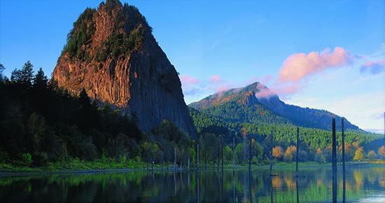
Lower lewis river falls north fork lewis river skamania county washington
Skamania County /skəˈmeɪniə/ is a county located in the U.S. state of Washington. As of the 2010 census, the population was 11,066. The county seat and largest incorporated city is Stevenson, although the Carson River Valley CDP is more populous. The county was founded in 1854 and derives its name from the Cascades Chinook word sk'mániak, meaning "swift waters".
Contents
- Lower lewis river falls north fork lewis river skamania county washington
- Map of Skamania County WA USA
- History
- Geography
- Geographic features
- Major highways
- Adjacent counties
- 2000 census
- 2010 census
- Recreation
- Parks and other protected areas
- County parks
- State parks
- Sites maintained by the US Forest Service
- National protected areas
- Cities
- Census designated place
- Unincorporated communities
- References
Map of Skamania County, WA, USA
Skamania County is included in the Portland-Vancouver-Hillsboro, OR-WA Metropolitan Statistical Area.
History
Skamania County was formed on March 9, 1854. On May 18, 1980, Mount St. Helens erupted.
Geography
According to the U.S. Census Bureau, the county has a total area of 1,684 square miles (4,360 km2), of which 1,656 square miles (4,290 km2) is land and 28 square miles (73 km2) (1.7%) is water. 90% of Skamania is forested and 80% is a part of Gifford Pinchot National Forest.
Geographic features
Major highways
Adjacent counties
2000 census
As of the census of 2000, there were 9,872 people, 3,755 households, and 2,756 families residing in the county. The population density was 6 people per square mile (2/km²). There were 4,576 housing units at an average density of 3 per square mile (1/km²). The racial makeup of the county was 92.11% White, 0.30% Black or African American, 2.20% Native American, 0.54% Asian, 0.17% Pacific Islander, 2.43% from other races, and 2.25% from two or more races. 4.03% of the population were Hispanic or Latino of any race. 17.7% were of German, 12.5% English, 12.1% Irish, 11.2% United States or American and 5.2% Norwegian ancestry.
There were 3,755 households out of which 34.00% had children under the age of 18 living with them, 60.50% were married couples living together, 8.20% had a female householder with no husband present, and 26.60% were non-families. 21.10% of all households were made up of individuals and 6.60% had someone living alone who was 65 years of age or older. The average household size was 2.61 and the average family size was 3.02.
In the county, the population was spread out with 26.60% under the age of 18, 6.70% from 18 to 24, 28.60% from 25 to 44, 27.10% from 45 to 64, and 11.00% who were 65 years of age or older. The median age was 39 years. For every 100 females there were 101.30 males. For every 100 females age 18 and over, there were 99.40 males.
The median income for a household in the county was $39,317, and the median income for a family was $44,586. Males had a median income of $36,732 versus $25,130 for females. The per capita income for the county was $18,002. About 10.00% of families and 13.10% of the population were below the poverty line, including 18.10% of those under age 18 and 7.90% of those age 65 or over.
There are more Seventh-day Adventists in Skamania County than members of any other religious group. Skamania County is the only county in the United States for which this is true.
2010 census
As of the 2010 United States Census, there were 11,066 people, 4,522 households, and 3,072 families residing in the county. The population density was 6.7 inhabitants per square mile (2.6/km2). There were 5,628 housing units at an average density of 3.4 per square mile (1.3/km2). The racial makeup of the county was 92.8% white, 1.6% American Indian, 0.9% Asian, 0.4% black or African American, 0.1% Pacific islander, 1.3% from other races, and 3.0% from two or more races. Those of Hispanic or Latino origin made up 5.0% of the population. In terms of ancestry, 20.6% were German, 15.7% were Irish, 11.0% were English, 6.3% were Norwegian, and 5.0% were American.
Of the 4,522 households, 28.4% had children under the age of 18 living with them, 54.3% were married couples living together, 8.9% had a female householder with no husband present, 32.1% were non-families, and 25.6% of all households were made up of individuals. The average household size was 2.44 and the average family size was 2.92. The median age was 44.0 years.
The median income for a household in the county was $ and the median income for a family was $. Males had a median income of $ versus $ for females. The per capita income for the county was $. About of families and of the population were below the poverty line, including of those under age 18 and of those age 65 or over.
Recreation
Parks and other protected areas
There are many parks in Skamania County. Only a few have been listed.