
- elevation 5,381 ft (1,640 m) Length 71 km | - elevation 79 ft (24 m) Basin area 1,036 km² | |
 | ||
Mouths | ||
Condit dam is breached letting the white salmon river run free
The White Salmon River is a 44-mile (71 km) tributary of the Columbia River in the U.S. state of Washington. Originating on the slopes of Mount Adams, it flows into the Columbia Gorge near the community of Underwood. Parts of the river have been designated Wild and Scenic. The principal tributaries of the White Salmon River include Trout Lake and Buck, Mill, Dry, Gilmer, and Rattlesnake Creeks.
Contents
- Condit dam is breached letting the white salmon river run free
- Map of White Salmon River Washington USA
- Wild and ScenicEdit
- RecreationEdit
- Condit Dam demolitionEdit
- References
Map of White Salmon River, Washington, USA
Wild and ScenicEdit
In 1986, the lower White Salmon River was designated Wild and Scenic between Gilmer Creek and Buck Creek. In 2005, the upper river between the headwaters and the boundary of the Gifford Pinchot National Forest was added to the designation. The two reaches, which are not contiguous, total 27.7 miles (44.6 km), of which 6.7 miles (10.8 km) are "wild" and 22.3 miles (35.9 km) are "scenic."
RecreationEdit
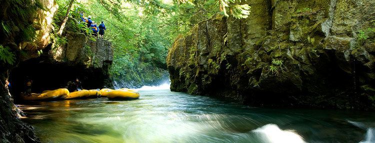
The White Salmon River is used for whitewater boating nearly year-round. A popular spot to launch a raft or kayak is the public put-in at the unincorporated community of BZ Corner. The day-use area at the put-in includes parking, restrooms, and toilets. Guided whitewater trips can be arranged with commercial outfitters with special-use permits for the White Salmon.
Condit Dam demolitionEdit
On October 26, 2011, the Condit Dam on the White Salmon River was intentionally breached as part of the dam's decommissioning by PacifiCorp. The breach allowed the river to flow unimpeded for the first time in nearly a century.