
Type natural Surface elevation 1,338 m Length 545 m Catchment area 182 ha | Primary inflows Max. length 1,788 ft (545 m) Area 13 ha Width 344 m | |
 | ||
Primary outflows Canyon Creek (Tributary) | ||
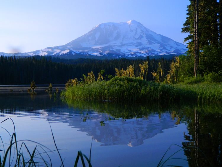
Midway High Lakes Area, also known as High Lakes Area is a United States Forest Service designated area located in Washington’s Cascade Mountains. It lies on a high plateau on Mount Adams' northwestern flank. It is between the Goat Rocks on the north and Mount Hood to the south and contains Takhlakh Lake along with several other lakes. The area offers five scenic high elevation lakes all within a seven mile radius. It is administered by the Gifford Pinchot National Forest. While even the most visited areas at Mount Adams pale in comparison to nearby St. Helens or Rainier, it is by its own standards one of the most popular recreational areas around Mount Adams. Some of the lakes offers photogenic views of Mount Adams from across the lake.
Contents
- Map of Midway High Lakes Area Washington USA
- GeographyEdit
- Major lakesEdit
- RecreationEdit
- Media and notabilityEdit
- References
Map of Midway High Lakes Area, Washington, USA
GeographyEdit
The Midway High Lakes Area lies below the volcanic peak of 12,276 feet (3,742 m) Mount Adams, and Adams Glacier cascading from the summit in a series of icefalls. It is the second largest glacier in the State of Washington, after Carbon Glacier on Mount Rainier. The area is characterized by several volcanic features in addition to Mount Adams, such as the Takh Takh Lava Flow, the Muddy Fork Lava Flows, and Potato Hill, a small 200 foot tall cinder cone below the Muddy Fork Lava Flows. There are some meadows and marshes, with Takh Takh Meadows being the most well known. Muddy Meadows is another named meadow in the High Lakes Area, near Riley Horse Camp and Muddy Meadows Trail accessing the Pacific Crest Trail and the Mount Adams Wilderness.
Major lakesEdit
The table below lists the five major lakes within the Midway High Lakes Area.
RecreationEdit
The High Lakes Area includes several lakes offering hiking, backpacking, fishing, non-motorized boating and canoeing, scenic driving, and developed and primitive camping experiences. The area offers several campgrounds including the popular Takhlakh Lake Campground. Other campgrounds are Olallie Lake Campground, Horseshoe Lake Campground, Killen Creek Campground, Council Lake Campground, Chain of Lakes Campground, Cat Creek Campground, Twin Falls Campground, and Adams Fork Campground. The popular and developed Walupt Lake Campground is also nearby, northeast of the Midway High Lakes Area at the southwestern base of the Goat Rocks. The area is the highlight of the 79-mile High Lakes Loop, a scenic driving loop in the White Pass National Scenic Byway beginning at Randle.
There are several waterfalls nearby, including Twin Falls, Steamboat Falls, Babyshoe Falls, Big Spring Creek Falls, and Riley Creek Falls.