
 | ||
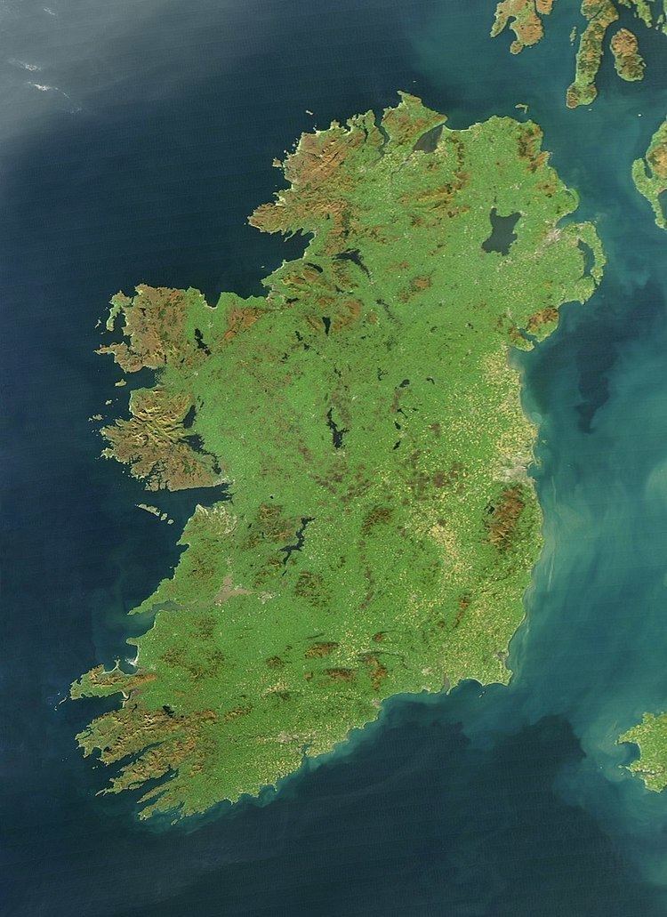
Ireland is an island in Northwestern Europe in the north Atlantic Ocean. The island lies on the European continental shelf, part of the Eurasian Plate. The island's main geographical features include low central plains surrounded by coastal mountains. The highest peak is Carrauntoohil (Irish: Corrán Tuathail), which is 1,041 metres (3,415 ft) above sea level. The western coastline is rugged, with many islands, peninsulas, headlands and bays. The island is bisected by the River Shannon, which at 360.5 km (224 mi) with a 102.1 km (63 mi) estuary is the longest river in Ireland and flows south from County Cavan in Ulster to meet the Atlantic just south of Limerick. There are a number of sizeable lakes along Ireland's rivers, of which Lough Neagh is the largest.
Contents
- Map of Ireland
- Geological development
- Mountain ranges
- Rivers and lakes
- Inlets
- Headlands
- Islands and peninsulas
- Climate
- Political and human geography
- References
Map of Ireland
Politically, the island consists of the Republic of Ireland, with jurisdiction over about five-sixths of the island; and Northern Ireland, a constituent country (and an unconfirmed "practical" exclave) of the United Kingdom, with jurisdiction over the remaining sixth. Located west of the island of Great Britain, it is located at approximately 53°N 8°W. It has a total area of 84,421 km2 (32,595 sq mi). It is separated from Great Britain by the Irish Sea and from mainland Europe by the Celtic Sea. Ireland and Great Britain, together with nearby islands, are known collectively as the British Isles; as the term British Isles is controversial in relation to Ireland, the alternative term 'Britain and Ireland' is increasingly preferred.
Geological development
The geology of Ireland is diverse. Different regions contain rocks belonging to different geologic periods, dating as far back almost 2 billion years. The oldest known Irish rock is about 1.7 billion years old and is found on Inishtrahull Island off the north coast of Inishowenand on the mainland at Annagh Head on the Mullet Peninsula. The newer formations are the drumlins and glacial valleys as a result of the last ice age, and the sinkholes and cave formations in the limestone regions of Clare.
Ireland's geologic history covers everything from volcanism and tropical seas to the last glacial period. Ireland was formed in two distinct parts and slowly joined together, uniting about 440 million years ago. As a result of tectonics and the effect of ice, the sea level has risen and fallen. In every area of the country the rocks which formed can be seen as a result. Finally, the impact of the glaciers shaped the landscape seen today. This variation in the two areas along with the differences between volcanic areas and shallow seas gives Ireland a range of soils as well. There are wide bogs and free-draining brown earths. The mountains are granite, sandstone, limestone with karst areas, and basalt formations.
Mountain ranges
Ireland consists of a mostly flat low-lying area in the midlands, ringed by mountain ranges such as (beginning in County Kerry and working counter-clockwise) the Macgillycuddy's Reeks, Comeragh Mountains, Blackstairs Mountains, Wicklow Mountains, the Mournes, Glens of Antrim, Sperrin Mountains, Bluestack Mountains, Derryveagh Mountains, Ox Mountains, Nephinbeg Mountains and the Twelve Bens/Maumturks group. Some mountain ranges are further inland in the south of Ireland, such as the Galtee Mountains (the highest inland range), Silvermine and Slieve Bloom Mountains. The highest peak Carrauntoohil, 1,038 m (3,405 ft) high, is in the Macgillycuddy's Reeks, a range of glacier-carved sandstone mountains. Ireland's mountains are not high – only three peaks are over 1,000 m (3,281 ft) and another 457 exceed 500 m (1,640 ft).
Rivers and lakes
The main river in Ireland is the River Shannon, 360.5 km (224.0 mi), the longest river in both the islands of Ireland and Britain, it is a river that separates the midlands of Ireland from the west of the island. The river develops into three lakes along its course, Lough Allen, Lough Ree, and Lough Derg. Of these, Lough Derg is the largest. The River Shannon enters the Atlantic Ocean after Limerick city at the Shannon Estuary. Other major rivers include the River Liffey, River Lee, River Blackwater, River Nore, River Suir, River Barrow, River Bann, River Foyle, River Erne, and River Boyne (see the list of rivers in Ireland).
Lough Neagh, in Ulster, is the largest lake in Ireland and Britain. Legend has it that a giant, Fionn mac Cumhail, was fighting with another in Scotland, and enraged, scooped out a lump of earth, which he threw. It fell into the Irish Sea, creating the Isle of Man, while the hole filled up with water to become Lough Neagh. Other large lakes include Lough Erne and Lough Corrib.
Inlets
Beginning with County Donegal, Lough Swilly separates one side of the Inishowen peninsula. Lough Foyle on the other side, is one of Ireland's larger inlets, situated between County Donegal and County Londonderry. Further round the coast is Belfast Lough, between County Antrim and County Down. Also in County Down is Strangford Lough, actually an inlet partially separating the Ards peninsula from the mainland. Further down the coast, Carlingford Lough is situated between Down and County Louth.
Dublin Bay is the next sizeable inlet, while the eastern coast of Ireland is mostly uniform until Wexford Harbour at the mouth of the River Slaney. On the southern coast, Waterford Harbour is situated at the mouth of the River Suir (into which the other two of the Three Sisters (River Nore and River Barrow) flow). The next major inlet is Cork Harbour, at the mouth of the River Lee, in which Great Island is situated.
Dunmanus Bay, Kenmare estuary and Dingle Bay are all inlets between the peninsulas of County Kerry. North of these is the Shannon Estuary. Between north County Clare and County Galway is Galway Bay. Clew Bay is located on the coast of County Mayo, south of Achill Island, while Broadhaven Bay, Blacksod Bay and Sruth Fada Conn bays are situated in northwest Connacht, in North Mayo. Killala Bay is on the northeast coast of Mayo. Donegal Bay is a major inlet between County Donegal and County Sligo.
Headlands
Malin Head is the most northerly point in Ireland, while Mizen Head is one of the most southern points, hence the term "Malin head to Mizen head" (or the reverse) is used for anything applying to the island of Ireland as a whole. Carnsore Point is another extreme point of Ireland, being the southeastern most point of Ireland. Further along the coast is Hook Head while the Old Head of Kinsale is one of many headlands along the south coast of Ireland.
Loop Head is the headland at which County Clare comes to a point on the west coast of Ireland, with the Atlantic on the north, and further inland on the south, the Shannon estuary. Hag's Head is another headland further up Clare's north/western coastline, with the Cliffs of Moher along the coastline north of the point.
Erris Head is the northwesternmost point of Connacht.
Islands and peninsulas
Apart from Ireland itself, Achill Island to its northwest is now considered the largest island in the group. The island is inhabited, and is connected to the mainland by a bridge. Some of the next largest islands are the Aran Islands, off the coast of southern Connacht, host to an Irish-speaking community, or Gaeltacht. Valentia Island off the Iveragh peninsula is also one of Ireland's larger islands, and is relatively settled, as well as being connected by a bridge at its southeastern end. Omey Island, off the coast of Connemara is a tidal island.
Some of the best-known peninsulas in Ireland are in County Kerry; the Dingle peninsula, the aforementioned Iveragh peninsula and the Beara peninsula. The Ards peninsula is one of the larger peninsulas outside Kerry. The Inishowen peninsula in County Donegal includes Ireland's most northerly point, Malin Head and several important towns including Buncrana on Lough Swilly, Carndonagh and Moville on Lough Foyle. Ireland's most northerly land feature is Inishtrahull island, off Malin Head. Rockall Island may deserve this honour but its status is disputed, being claimed by the United Kingdom, Republic of Ireland, Denmark (for the Faroe Islands) and Iceland. The most southerly point is the Fastnet Rock.
The Hebrides off Scotland and Anglesey off Wales were grouped with Ireland ("Hibernia") by the Greco-Roman geographer Ptolemy, but this is no longer common.
Climate
The climate of Ireland is mild, moist and changeable with abundant rainfall and a lack of temperature extremes. Ireland's climate is defined as a temperate oceanic climate, or Cfb on the Köppen climate classification system, a classification it shares with most of northwest Europe. The country receives generally warm summers and mild winters. It is considerably warmer than other areas at the same latitude on the other side of the Atlantic, such as in Newfoundland, because it lies downwind of the Atlantic Ocean. It is also warmer than maritime climates near the same latitude, such as the Pacific Northwest and as a result heat released by the Atlantic overturning circulation that includes ocean North Atlantic Current and Gulf Stream. For comparison, Dublin is 9 °C warmer than St. John's in Newfoundland in winter and 4 °C warmer than Seattle in the Pacific Northwest in winter.
The influence of the North Atlantic Current also ensures the coastline of Ireland remains ice-free throughout the winter—unlike for example the Sea of Okhotsk and the Labrador Sea which are at a similar latitude. The climate in Ireland does not experience extreme weather, with tornadoes and similar weather features being rare.
The prevailing wind comes from the southwest, breaking on the high mountains of the west coast. Rainfall is therefore a particularly prominent part of western Irish life, with Valentia Island, off the west coast of County Kerry, getting almost twice as much annual rainfall as Dublin on the east (1,400 mm or 55.1 in vs. 762 mm or 30.0 in).
January and February are the coldest months of the year, and mean daily air temperatures fall between 4 and 7 °C (39.2 and 44.6 °F) during these months. July and August are the warmest, with mean daily temperatures of 14 to 16 °C (57.2 to 60.8 °F), whilst mean daily maximums in July and August vary from 17 to 18 °C (62.6 to 64.4 °F) near the coast, to 19 to 20 °C (66.2 to 68.0 °F) inland. The sunniest months are May and June, with an average of five to seven hours sunshine per day.
Though extreme weather events in Ireland are comparatively rare when compared with other countries in the European Continent, they do occur. Atlantic depressions, occurring mainly in the months of December, January and February, can occasionally bring winds of up to 160 km/h or 99 mph to Western coastal counties; while the summer months, and particularly around late July/early August, thunderstorms can develop.
The table shows mean climate figures for the Dublin Airport weather station over a thirty-year period. Climate statistics based on the counties of Northern Ireland vary slightly but are not significantly different.
Political and human geography
Ireland is divided into four provinces, Connacht, Leinster, Munster and Ulster, and 32 counties. Six of the nine Ulster counties form Northern Ireland and the other 26 form the state, Ireland. The map shows the county boundaries for all 32 counties.
From an administrative viewpoint, 21 of the counties in the republic are units of local government. The other six have more than one local council area, producing a total of 31 county-level authorities. County Tipperary had two ridings, North Tipperary and South Tipperary, originally established in 1838, renamed in 2001 and amalgamated in 2014. The cities of Dublin, Cork and Galway have city councils and are administered separately from the counties bearing those names. The cities of Limerick and Waterford were merged with their respective county councils in 2014 to form new city and county councils. The remaining part of County Dublin is divided into Dún Laoghaire–Rathdown, Fingal, and South Dublin.
Electoral areas in Ireland (the state), called constituencies in accordance with Irish law, mostly follow county boundaries. Maintaining links to the county system is a mandatory consideration in the re-organisation of constituency boundaries by a Constituency Commission.
In Northern Ireland, a major re-organisation of local government in 1973 replaced the six traditional counties and two county boroughs (Belfast and Derry) by 26 single-tier districts, which, apart from Fermanagh cross the traditional county boundaries. The six counties and two county-boroughs remain in use for purposes such as Lieutenancy. In November 2005, proposals were announced which would see the number of local authorities reduced to seven. The island's total population of approximately 6 million people is concentrated on the east coast, particularly in Dublin and Belfast and their surrounding areas.