
Major islands Achill Highest elevation 688 m (2,257 ft) Elevation 688 m | Archipelago Achill Coastline 128 km (79.5 mi) Area 148 km² Population 2,700 (2006) Island group British Isles | |
 | ||
Points of interest Slieve, Keel Beach, Achill‑henge, Old St Dympna's, Croaghaun | ||
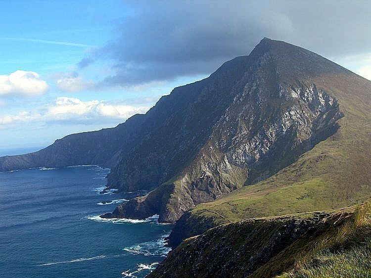
Amazing scenery atlantic drive achill island county mayo ireland
Achill Island (/ˈækəl/; Irish: Acaill, Oileán Acla) in County Mayo is the largest island off the coast of Ireland, and is situated off the west coast. It has a population of 2,700. Its area is 148 km2 (57 sq mi). Achill is attached to the mainland by Michael Davitt Bridge, between the villages of Gob an Choire (Achill Sound) and Poll Raithní (Polranny). A bridge was first completed here in 1887, replaced by another structure in 1949, and subsequently replaced with the current bridge which was completed in 2008. Other centres of population include the villages of Keel, Dooagh, Dumha Éige (Dooega), Dún Ibhir (Dooniver), The Valley and Dugort. The parish's main Gaelic football pitch and secondary school are on the mainland at Poll Raithní. Early human settlements are believed to have been established on Achill around 3000 BC. A paddle dating from this period was found at the crannóg near Dookinella. The island is 87% peat bog. The parish of Achill also includes the Curraun peninsula. Some of the people of Curraun consider themselves Achill people, and most natives of Achill refer to this area as being "in Achill". There are between 500-600 native Irish speakers in Achill parish. In the summer of 1996, the RNLI decided to station a lifeboat at Kildownet.
Contents
- Amazing scenery atlantic drive achill island county mayo ireland
- Map of Achill Island Co Mayo Ireland
- The deserted village achill island county mayo ireland 2014 part 1
- History
- Overlords
- Immigration
- Grace OMalleys Castle
- Achill Mission
- Railway
- Kildamhnait
- The Monastery
- The Valley House
- The Deserted Village
- Archaeology
- Other places of interest
- Economy
- Religion
- Education
- Transport
- Cuisine
- Sport
- Population
- Demographics
- Architecture
- Notable people
- Literature
- References
Map of Achill Island, Co. Mayo, Ireland
The deserted village achill island county mayo ireland 2014 part 1
History
It is believed that at the end of the Neolithic Period (around 4000 BC), Achill had a population of 500–1,000 people. The island would have been mostly forest until the Neolithic people began crop cultivation. Settlement increased during the Iron Age, and the dispersal of small promontory forts around the coast indicate the warlike nature of the times. Megalithic tombs (see picture, right) and forts can be seen at Slievemore, along the Atlantic Drive and on Achillbeg.
Overlords
Achill Island lies in the Barony of Burrishoole, in the territory of ancient Umhall (Umhall Uactarach and Umhall Ioctarach), that originally encompassed an area extending from the County Galway/Mayo border to Achill Head.
The hereditary chieftains of Umhall were the O'Malleys, recorded in the area in 814 AD when they successfully repelled an onslaught by the Vikings in Clew Bay. The Anglo-Norman invasion of Connacht in 1235 AD saw the territory of Umhall taken over by the Butlers and later by the de Burgos. The Butler Lordship of Burrishoole continued into the late 14th century when Thomas le Botiller was recorded as being in possession of Akkyll & Owyll.
Immigration
In the 17th and 18th centuries, there was much migration to Achill from other parts of Ireland, particularly Ulster, due to the political and religious turmoil of the time. For a while there were two different dialects of Irish being spoken on Achill. This led to many townlands being recorded as having two names during the 1824 Ordnance Survey, and some maps today give different names for the same place. Achill Irish still has many traces of Ulster Irish.
Grace O'Malley's Castle
Carrickkildavnet Castle is a 15th-century tower house associated with the O'Malley Clan, who were once a ruling family of Achill. Grace O' Malley, or Granuaile, the most famous of the O'Malleys, was born on Clare Island around 1530. Her father was the chieftain of the barony of Murrisk. The O'Malleys were a powerful seafaring family, who traded widely. Grace became a fearless leader and gained fame as a sea captain and pirate. She is reputed to have met with Queen Elizabeth I in 1593. She died around 1603 and is buried in the O'Malley family tomb on Clare Island.
Achill Mission
One of Achill's most famous historical sites is that of the Achill Mission or 'the Colony' at Dugort. In 1831 the Church of Ireland Reverend Edward Nangle founded a proselytising mission at Dugort. The Mission included schools, cottages, an orphanage, an infirmary and a guesthouse. The Colony was very successful for a time and regularly produced a newspaper called the Achill Herald and Western Witness. Nangle expanded his mission into Mweelin, where a school was built. The Achill Mission began to decline slowly after Nangle was moved from Achill and was finally closed in the 1880s. Nangle died in 1883.
Railway
In 1894, the Westport - Newport railway line was extended to Achill Sound. The train station is now a hostel. The train provided a great service to Achill, but it also fulfilled an ancient prophecy. Brian Rua O' Cearbhain had prophesied that 'carts on iron wheels' would carry bodies into Achill on their first and last journey. In 1894, the first train on the Achill railway carried the bodies of victims of the Clew Bay Drowning. This tragedy occurred when a boat overturned in Clew Bay, drowning thirty-two young people. They had been going to meet the steamer which would take them to Scotland for potato picking.
Kirkintilloch Fire
The Kirkintilloch Fire in 1937 fulfilled the second part of the prophecy when the bodies of ten victims were carried by rail to Achill. These people had died in a fire in a bothy in Kirkintilloch. This term referred to the temporary accommodation provided for those who went to Scotland to pick potatoes, a migratory pattern that had been established in the early nineteenth century.
Kildamhnait
Kildamhnait on the south-east coast of Achill is named after St. Damhnait, or Dymphna, who founded a church there in the 16th century. There is also a holy well just outside the graveyard. The present church was built in the 1700s and the graveyard contains memorials to the victims of two of Achill's greatest tragedies, the Kirchintilloch Fire (1937) and the Clew Bay Drowning (1894).
The Monastery
In 1852, Dr. John McHale, Archbishop of Tuam set aside land in Bunnacurry for the building of a monastery. A Franciscan Monastery was built which, for many years provided an education for local children. The ruins of this monastery are still to be seen in Bunnacurry today.
The Valley House
The historic Valley House is located in The Valley, near Dugort in the north-east of Achill Island. The present building sits on the site of a hunting lodge built by the Earl of Cavan in the 19th century. Its notoriety arises from an incident in 1894 in which the then owner, an English landlady named Agnes McDonnell, was savagely beaten and the house set alight, allegedly by a local man, James Lynchehaun. Lynchehaun had been employed by McDonnell as her land agent, but the two fell out and he was sacked and told to quit his accommodation on her estate. A lengthy legal battle ensued, with Lynchehaun refusing to leave. At the time, in the 1890s, the issue of land ownership in Ireland was politically charged, and after the events at the Valley House in 1894 Lynchehaun was to claim that his actions were motivated by politics. He escaped custody and fled to the United States, where he successfully defeated legal attempts by the British authorities to have him extradited to face charges arising from the attack and the burning of the Valley House. Agnes McDonnell suffered terrible injuries from the attack but survived and lived for another 23 years, dying in 1923. Lynchehaun is said to have returned to Achill on two occasions, once in disguise as an American tourist, and eventually died in Girvan, Scotland, in 1937. The Valley House is now a hostel and Bar.
The Deserted Village
Close by Dugort, at the base of Slievemore mountain lies the Deserted Village. There are approximately 80 ruined houses in the village.
The houses were built of unmortared stone, which means that no cement or mortar was used to hold the stones together. Each house consisted of just one room and this room was used as a kitchen, living room, bedroom and even a stable.
If one looks at the fields around the Deserted Village and right up the mountain, one can see the tracks in the fields of 'lazy beds', which is the way crops like potatoes were grown. In Achill, as in many areas of Ireland, a system called 'Rundale' was used for farming. This meant that the land around a village was rented from a landlord. This land was then shared by all the villagers to graze their cattle and sheep. Each family would then have two or three small pieces of land scattered about the village, which they used to grow crops.
For many years people lived in the village and then in 1845 Famine struck in Achill as it did in the rest of Ireland. Most of the families moved to the nearby village of Dooagh, which is beside the sea, while some others emigrated. Living beside the sea meant that fish and shellfish could be used for food. The village was completely abandoned which is where the name 'Deserted Village' came from.
No one has lived in these houses since the time of the Famine, however, the families that moved to Dooagh and their descendants, continued to use the village as a 'booley village'. This means that during the summer season, the younger members of the family, teenage boys and girls, would take the cattle to graze on the hillside and they would stay in the houses of the Deserted Village. This custom continued until the 1940s. Boolying was also carried out in other areas of Achill, including Annagh on Croaghaun mountain and in Curraun.
At Ailt, Kildownet, you can see the remains of a similar deserted village. This village was deserted in 1855 when the tenants were evicted by the local landlord so the land could be used for cattle grazing, the tenants were forced to rent holdings in Currane, Dooega and Slievemore. Others emigrated to America.
Archaeology
Achill Archaeological Field School is based at the Achill Archaeology Centre in Dooagh, which has served as a catalyst for a wide array of archaeological investigations on the island. It was founded in 1991 and is a training school for students of archaeology and anthropology. Since 1991, several thousand students from 21 countries have come to Achill to study and participate in ongoing excavations. The school is involved in a study of the prehistoric and historic landscape at Slievemore, incorporating a research excavation at a number of sites within the deserted village of Slievemore. Slievemore is rich in archaeological monuments that span a 5,000 year period from the Neolithic to the Post Medieval. Recent archaeological research suggests the village was occupied year-round at least as early as the 19th century, though it is known to have served as a seasonally occupied booley village by the first half of the 20th century. A booley village (a number of which exist in a ruined state on the island) is a village occupied only during part of the year, such as a resort community, a lake community, or (as the case on Achill) a place to live while tending flocks or herds of ruminants during winter or summer pasturing. Specifically, some of the people of Dooagh and Pollagh would migrate in the summer to Slievemore and then go back to Dooagh in the autumn. The summer 2009 field school excavated Round House 2 on Slievemore Mountain under the direction of archaeologist Stuart Rathbone. Only the outside north wall, entrance way and inside of the Round House were completely excavated.
From 2004 to 2006, the Achill Island Maritime Archaeology Project directed by Chuck Meide was sponsored by the College of William and Mary, the Institute of Maritime History, the Achill Folklife Centre (now the Achill Archaeology Centre), and the Lighthouse Archaeological Maritime Program (LAMP). This project focused on the documentation of archaeological resources related to Achill's rich maritime heritage. Maritime archaeologists recorded 19th century fishing station, ice house, and boat house ruins, a number of anchors which had been salvaged from the sea, 19th century and more recent currach pens, a number of traditional vernacular watercraft including a possibly 100-year-old Achill yawl, and the remains of four historic shipwrecks.
Other places of interest
Despite some development, the island retains a striking natural beauty. The cliffs of Croaghaun on the western end of the island are the third highest sea cliffs in Europe but are inaccessible by road. Near the westernmost point of Achill, Achill Head, is Keem Bay. Keel Beach is quite popular with tourists and some locals as a surfing location. South of Keem beach is Moytoge Head, which with its rounded appearance drops dramatically down to the ocean. An old British observation post, built during World War I to prevent the Germans from landing arms for the Irish Republican Army, is still standing on Moytoge. During the Second World War this post was rebuilt by the Irish Defence Forces as a Look Out Post for the Coast Watching Service wing of the Defence Forces. It operated from 1939 to 1945.
The mountain Slievemore (672 m) rises dramatically in the north of the island and the Atlantic Drive (along the south/west of the island) has some dramatically beautiful views. On the slopes of Slievemore, there is an abandoned village (the "Deserted Village") The Deserted Village is traditionally thought to be a remnant village from An Gorta Mór (The Great Hunger of 1845-1849).
Just west of the deserted village is an old Martello tower, again built by the British to warn of any possible French invasion during the Napoleonic Wars. The area also boasts an approximately 5000-year-old Neolithic tomb.
Achillbeg (Acaill Beag, Little Achill) is a small island just off Achill's southern tip. Its inhabitants were resettled on Achill in the 1960s. A plaque to Johnny Kilbane is situated on Achillbeg and was erected to celebrate 100 years since his first championship win.
The villages of Dooniver and Askill have very picturesque scenery and the cycle route is popular with tourists.
Caisleán Ghráinne, also known as Kildownet Castle, is a small tower house built in the early 1400s. It is located in Cloughmore, on the south of Achill Island. It is noted for its associations with Grace O'Malley, along with the larger Rockfleet Castle in Newport.
Achill Island also has a coast road along the south of the Island with some beautiful cliff views.
Economy
While a number of attempts at setting up small industrial units on the island have been made, the economy of the island is largely dependent on tourism. Subventions from Achill people working abroad, in particular in the United Kingdom, the United States and Africa allowed many families to remain living in Achill throughout the 19th and 20th centuries. Since the advent of Ireland's "Celtic Tiger" economy fewer Achill people were forced to look for work abroad. Agriculture plays a small role and the fact that the island is mostly bog means that its potential for agriculture is limited largely to sheep farming. In the past, fishing was a significant activity but this aspect of the economy is small now. At one stage, the island was known for its shark fishing, basking shark in particular was fished for its valuable liver oil. There was a big spurt of growth in tourism in the 1960s and 1970s before which life was tough and difficult on the island. Despite healthy visitor numbers each year, the common perception is that tourism in Achill has been slowly declining since its heyday. Currently, the largest employers on Achill are two hotels. In late 2009 Ireland's only Turbot farm opened in the Bunnacurry Business Park.
Religion
Most people on Achill are either Roman Catholic or Anglican (Church of Ireland). There are three priests on Achill and eight churches in total.
Education
Hedge schools existed in most villages of Achill in various periods of history. A university was started by the missions to Achill in Mweelin. In the modern age, there used to be two secondary schools in Achill, Mc Hale College and Scoil Damhnait. However, in August 2011, the two schools amalgamated to form Coláiste Pobail Acla. For primary education, there are nine National Schools including Bullsmouth NS, Valley NS, Bunnacurry NS, Dookinella NS, Dooagh NS, Saulia NS, Achill Sound NS, Tonragee NS and Curanne NS. National schools closed down include Dooega NS, Crumpaun NS, Ashleam NS.
Transport
Cuisine
As a popular tourist destination, Achill has many bars, cafes and restaurants which serve a full range of food. However, with the island's Atlantic location seafood is a speciality on Achill with common foods including lobster, mussels, salmon, trout and winkles. With a large sheep population, Achill lamb is a very popular meal on the island too. Furthermore, Achill has a big population of cows which produces excellent beef.
Sport
Achill has a Gaelic football club which competes in the intermediate championship and division 1C of the Mayo League. There are also Achill Rovers which play in the Mayo Association Football League. and Achill Golf Club. Card games, including Whist and 24 card game are also popular on Achill. The island's primary recreational outdoor centre is Achill Outdoor Education Centre. Achill Island's rugged landscape and the surrounding ocean offers a prime location for outdoor adventure activities, like surfing, kite-surfing and sea kayaking. Fishing and watersports are popular with tourists and locals alike. Sailing regattas featuring a local vessel type, the Achill Yawl, have been popular since the 19th century, though most present-day yawls, unlike their traditional working boat ancestors, have been structurally modified to promote greater speed under sail. The island's waters and striking underwater sites are occasionally visited by scuba divers, though Achill's unpredictable weather generally has precluded a commercially successful recreational diving industry.
Population
In 2011, the population was 2,569. The island's population has declined from around 6,000 before the Great Hunger.
Demographics
The table below reports data on Achill Island's population taken from Discover the Islands of Ireland (Alex Ritsema, Collins Press, 1999) and the census of Ireland.
Architecture
Because of the inhospitable climate, few inhabited houses date from before the 20th century, though there are many examples of abandoned stone structures dating to the 19th century.
The best known of these earlier can be seen in the "Deserted Village" ruins near the graveyard at the foot of Slievemore. Even the houses in this village represent a relatively comfortable class of dwelling as, even as recently as a hundred years ago, some people still used "Beehive" style houses (small circular single-roomed dwellings with a hole in the ceiling to let out smoke).
Many of the oldest and most picturesque inhabited cottages date from the activities of the Congested Districts Board for Ireland—a body set up around the turn of the 20th century in Ireland to improve the welfare of the inhabitants of small villages and towns. Most of the homes in Achill at the time were very small and tightly packed together in villages. The CDB subsidised the building of new, more spacious (though still small by modern standards) homes outside of the traditional villages.
Some of the recent building development (1980 and onwards) on the island does fit as nicely in the landscape as the earlier style of whitewashed raised gable cottages. Many holiday homes have been built but many of these houses have been built in prominent scenic areas and have damaged traditional views of the island while lying empty for most of the year.
Notable people
Literature
Heinrich Böll: Irisches Tagebuch, Berlin 1957
Kingston, Bob: The Deserted Village at Slievemore, Castlebar 1990
McDonald, Theresa: Achill: 5000 B.C. to 1900 A.D. Archeology History Folklore, I.A.S. Publications [1992]
Meehan, Rosa: The Story of Mayo, Castlebar 2003
Carney, James: The Playboy & the Yellow lady, 1986 POOLBEG
Hugo Hamilton: The Island of Talking, 2007
Kevin Barry: Beatlebone, 2015