
Elevation 544 m | Provinces of Ireland Connacht Highest point Knockalongy | |
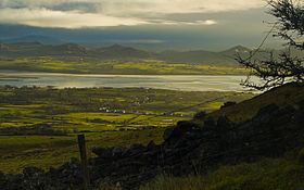 | ||
The Ox Mountains (Irish: Sliabh Gamh) are a mountain range in County Sligo on the west coast of Ireland. They are also known as Saint Patrick's Mountains after the saint who built churches on its slopes and left his name to some of its wells.
Contents
Map of Ox Mountains, Trasgarve, Co. Sligo, Ireland
Geography
The highest peak in the Ox Mountains is Knockalongy, which is 544 metres (1,785 ft) high.
The mountains begin immediately southwest of Ballysadare, and run west-southwest for some forty miles to the boundary of County Mayo, where they are continued to the southwest by the Slieve Gamph range, which runs first on the boundary of the two counties, and then into Mayo. The mountains have several summits from 1,200 to 1,800 feet high; and Slieve Gamph reaches 1,363 feet.
Geology
Gneiss, schist and granite form the bedrock of the Ox Mountains. This wild area of uplands is covered largely with blanket bog. Some parts are extensively forested, whilst others have numerous outcroppings of rock. To the north and south the land is underlain by limestones and sandstones of Carboniferous age, and is generally farmland. Lead and copper mines were formerly worked in the Ox Mountains, but by 1900, the works had been long since discontinued.