
Location North-east Atlantic Highest elevation 17.15 m (56.27 ft) Population 0 Elevation 17 m | OS grid reference MC035165 Area 784.3 m² Max width 25 m | |
 | ||
Island groups British Isles, Outer Hebrides | ||
Rockall scorpion rib adventure
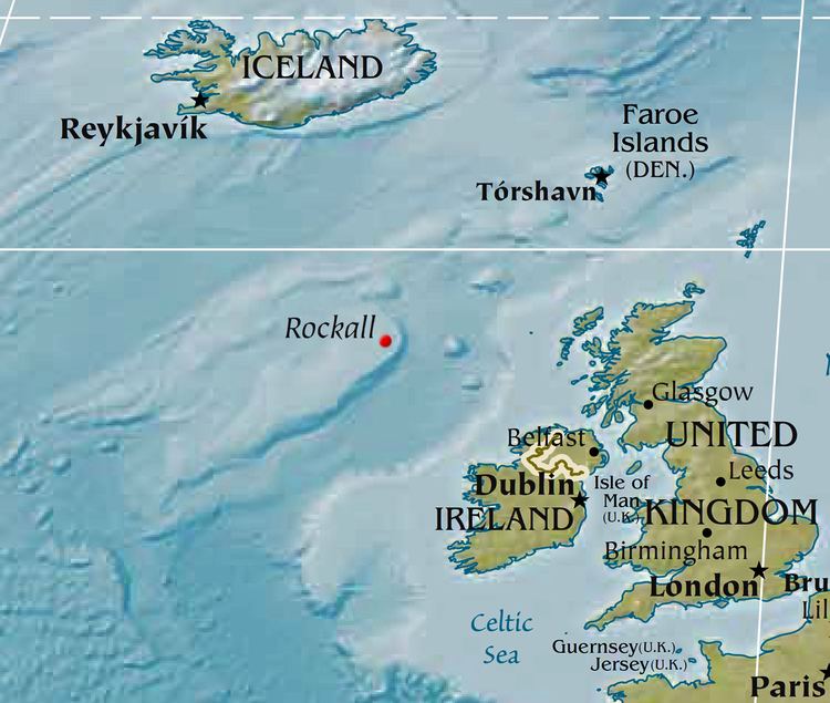
Rockall /ˈrɒkɔːl/ is an uninhabited granite islet within the exclusive economic zone (EEZ) of the United Kingdom, situated in the North Atlantic Ocean. Its rough distances from the closest large islands are: 430 km (270 miles) north-west of Ireland, 460 km (290 miles) west of Great Britain and 700 km (440 miles) south of Iceland. The nearest permanently inhabited place is North Uist, an island in the Outer Hebrides of Scotland, 370 km (230 miles) to the east.
Contents
- Rockall scorpion rib adventure
- Rockall
- Etymology
- History
- Geography
- Geology
- Ecology
- Discovery of new species
- Visits to Rockall
- United Kingdom
- Ireland
- Shipping disasters
- In popular culture
- References
The United Kingdom incorporated Rockall in 1955. It does not make a claim to extended EEZ based on Rockall and the Country has ratified the United Nations Convention on the Law of the Sea (UNCLOS), which says that "rocks which cannot sustain human habitation or economic life of their own shall have no exclusive economic zone or continental shelf". However, such features are entitled to a territorial sea extending 12 nautical miles. Historically, Ireland did not recognise Britain's claim to the rock or the territorial sea surrounding it. With effect from 31 March 2014, the UK and Ireland published EEZ limits which resolved any disputes over the extent of their respective EEZs.
In response to a Freedom of Information request the British Government has written, "The islet of Rockall is part of the UK: specifically it forms part of Scotland under the Island of Rockall Act 1972. No other state has disputed our claim to the islet."
Rockall
Etymology
The origin and meaning of the name "Rockall" are uncertain. The Old Norse name for the islet, Ròcal, may contain the element fjall, meaning "mountain". It has also been suggested that the name is from the Norse *rok, meaning "foaming sea", and kollr, meaning "bald head"—a word which appears in other placenames in Scandinavian-speaking areas. Another idea is that it derives from the Gaelic Sgeir Rocail, meaning "skerry of roaring" or "sea rock of roaring" (although rocail can also be translated as "tearing" or "ripping").
Dutch mapmakers P. Plancius and C. Claesz show an island called "Rookol" northwest of Ireland on their Map of New France and the Northern Atlantic Ocean (Amsterdam, c. 1594). The first literary reference to the island, where it is called "Rokol", is found in Martin Martin's A Description of the Western Isles of Scotland published in 1703. This book gives an account of a voyage to the archipelago of St. Kilda, and Martin states: "... and from it lies Rokol, a small rock sixty leagues to the westward of St. Kilda; the inhabitants of this place call it Rokabarra."
The name Rocabarraigh is also used in Scottish Gaelic folklore for a mythical rock which is supposed to appear three times, its last appearance being at the end of the world: "Nuair a thig Rocabarra ris, is dual gun tèid an Saoghal a sgrios." (When Rocabarra returns, the world will likely come to be destroyed.)
History
Since the late 16th century, the 17.15 metre (56.27 ft) high rock has been noted in written records, although it is likely that some northern Atlantic fishermen knew of the rock before these historical accounts were made. In the 20th century, the location of the islet became a major interest due to the potential oil and fishing rights, spurring continued debate amongst several European nations.
Lord Kennet said of it in 1971, "There can be no place more desolate, despairing and awful." It gives its name to one of the sea areas named in the Shipping Forecast provided by the British Meteorological Office.
Rockall has been a point of interest for adventurers and amateur radio operators who have variously landed on or briefly occupied the islet. Fewer than 20 individuals have ever been confirmed to have landed on Rockall, and the longest continuous stay by an individual is currently 45 days. In a House of Commons debate in 1971, William Ross, MP for Kilmarnock, said: "More people have landed on the moon than have landed on Rockall."
Geography
The islet of Rockall is one of the few pinnacles of the surrounding Helen's Reef. It is located 301.3 km, or 162.7 nmi west of the island of Soay, St Kilda, Scotland, and 423.2 kilometres (263.0 miles; 228.5 nautical miles) northwest of Tory Island, County Donegal, Ireland. Rockall's location was precisely determined by Nick Hancock during his 2014 expedition. The surrounding elevated seabed is called the Rockall Bank, lying directly south from an area known as the Rockall Plateau. It is separated from the Outer Hebrides by the Rockall Trough, itself located within the Rockall Basin (also known as the "Hatton Rockall Basin").
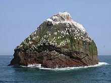
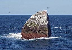
In 1956 the British scientist James Fisher referred to the island as "the most isolated small rock in the oceans of the world". The neighbouring Hasselwood Rock and several other pinnacles of the surrounding Helen's Reef are smaller, at half the size of Rockall or less, and equally remote, but those formations are legally not islands or points on land, as they are often submerged completely, only revealed momentarily above certain types of ocean surface waves.
Cold-water coral mounds have been identified in the region, and are currently being researched. Rockall lies near the Darwin Mounds, deep water coral mounds about 185 km (100 nmi or 115 mi) northwest of Cape Wrath. These corals are long-lived and slow-growing, a justification for designating Rockall and the Rockall waters as a Marine Protected Area.
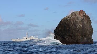
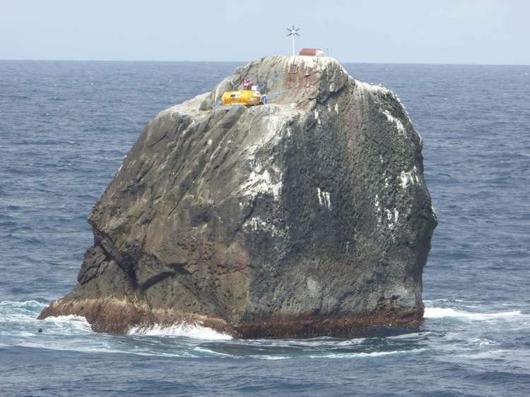
Rockall is about 25 metres (80 ft) wide and 31 metres (100 ft) long at its base and rises sheer to a height of 17.15 m (56.27 ft). It is often washed over by large storm waves, particularly in winter. There is a small ledge of 3.5 by 1.3 metres (11.5 by 4.3 ft), known as Hall's Ledge, 4 metres (13 ft) from the summit on the rock's western face. It is the only named geographical location on the rock.
The nearest point on land from Rockall is 301.3 km, or 162.7 nmi, east at the uninhabited Scottish island of Soay in the St Kilda archipelago. The nearest inhabited area lies 303.2 km, or 163.7 nmi, east at Hirta, the largest island in the St. Kilda group, which is populated intermittently at a single military base. The nearest permanently inhabited settlement is 366.8 km, or 198.1 nmi, west of the headland of Aird an Runair, near the crofting township of Hogha Gearraidh on the island of North Uist at NF705711 (57°36′33″N 7°31′7″W). North Uist is part of the Na h-Eileanan Siar council area of Scotland.
The exact position of Rockall and the size and shape of the Rockall Bank was first charted in 1831 by CAPTAIN A.T.E. Vidal, a Royal Navy surveyor. The first scientific expedition to Rockall was led by Miller Christie in 1896 when the Royal Irish Academy sponsored a study of the flora and fauna. They chartered the Granuaile.
A detailed underwater mapping of the area around Rockall undertaken in 2011 by FRV Scotia showed that Rockall itself is a minor pinnacle, whilst Helen's Reef extends in a sweeping arc of fissures and ridges to the north-west of the islet. Between the islet and Helen's Reef is a deeper trench much used by squid fishermen.
Geology
Rockall is made of a type of peralkaline granite that is relatively rich in sodium and potassium. Within this granite are darker bands richer in iron because they contain the pyroxene mineral aegirine and the amphibole mineral riebeckite. The dark bands are a type of granite that geologists have named "rockallite", although use of this term is now discouraged. In 1975, a mineral new to science was discovered on Rockall. The mineral is called bazirite, (chemical composition BaZrSi3O9), named after the elements barium and zirconium.
Rockall forms part of the deeply eroded Rockall Igneous Centre that was formed as part of the North Atlantic Igneous Province, approximately 55 million years ago, when the ancient continent of Laurasia was split apart by plate tectonics. Greenland and Europe separated and the northeast Atlantic Ocean was formed between them.
The RV Celtic Explorer surveyed the Rockall Bank and North West of Donegal in 2003. The ILV Granuaile (the same name as the steamer on the RIA 1896 botany survey) was chartered by the Geological Survey of Ireland (GSI), on behalf of the Department of Communications, Marine and Natural Resources (DCMNR), to conduct a seismic survey at the Rockall and Hatton Banks in July 2004, as part of the National Seabed Survey.
Ecology
The island's only permanent macro-organism inhabitants are common periwinkles and other marine molluscs. Small numbers of seabirds, mainly fulmars, northern gannets, black-legged kittiwakes, and common guillemots, use the rock for resting in summer, and gannets and guillemots occasionally breed successfully if the summer is calm with no storm waves washing over the rock. In total there have been just over twenty species of seabird and six other animal species observed (including the aforementioned molluscs) on or near the islet.
Discovery of new species
In December 2013 surveys by Marine Scotland discovered four new species of animals in the sea around Rockall. These are believed to live in an area where hydrocarbons are released from the sea bed, known as a cold seep. The discovery has raised the issue of restricting some forms of fishery to protect the sea bed. The species are:
Visits to Rockall
The earliest recorded date for landing on the island is often given as 8 July 1810, when a Royal Navy officer named Basil Hall led a small landing party from the frigate HMS Endymion to the summit. Research by James Fisher of the 1955 landing (see below) in the log of the Endymion and elsewhere indicates that the true date for this first landing was Sunday 8 September 1811.
The landing party left the Endymion for the rock by boat. While they were on the rock, the Endymion, which was taking depth measurements around Rockall, lost visual contact with the rock as a haze descended. The ship drifted away, leaving the landing party stranded. The expedition made a brief attempt to return to the ship, but could not find the frigate in the haze, and soon gave up and returned to Rockall. After the haze became a fog, the lookout sent to the top of Rockall spotted the ship again, but it turned away from Rockall before the expedition in their boats reached it. Finally, just before sunset, the frigate was again spotted from the top of Rockall, and the expedition was able to get back on board. The crew of the Endymion reported that they had been searching for five or six hours, firing their cannon every ten minutes. Hall related this experience and other adventures in a book entitled Fragment of Voyages and Travels Including Anecdotes of a Naval Life.
The next landing was accomplished by a Mr Johns of HMS Porcupine whilst the ship was on a mission, from June and August 1862, to make a survey of the sea bed prior to the laying of a transatlantic telegraph cable. Johns managed to gain foothold on the island, but failed to reach the summit.
On 18 September 1955, Rockall was annexed by the British Crown when Lieutenant-Commander Desmond Scott RN, Sergeant Brian Peel RM, Corporal AA Fraser RM, and James Fisher (a civilian naturalist and former Royal Marine), were winched by a helicopter onto the island by a Royal Navy helicopter from HMS Vidal (coincidentally named after the man who first charted the island). The annexation of Rockall was announced by the Admiralty on 21 September 1955.
The expedition team cemented in a brass plaque on Hall's Ledge and hoisted the Union Flag to stake the UK's claim. The inscription on the plaque read:
By authority of Her Majesty Queen Elizabeth II, by the Grace of God of the United Kingdom of Great Britain and Northern Ireland and of her other realms and territories Queen, HEAD OF THE COMMONWEALTH, Defender of the Faith, and in accordance with Her Majesty's instructions dated the 14th day of September, 1955, a landing was effected this day upon this island of Rockall from HMS Vidal. The Union flag was hoisted and possession of the island was taken in the name of Her Majesty. [Signed] R H Connell, Captain, HMS Vidal, 18 September 1955.
On 7 November 1955, J. Abrach Mackay, a member of the Clan Mackay, made a protest about the annexation; the 84-year-old local councillor declared: "My old father, God rest his soul, claimed that island for the Clan of Mackay in 1846 and I now demand that the Admiralty hand it back. It's no' theirs'." The British Government ignored the protests, which were soon forgotten.
The initial incentive was the test-firing of the UK's first guided nuclear weapon, the American-made Corporal missile. The missile was to be launched from South Uist and over the North Atlantic. The Ministry of Defence was concerned that the unclaimed island would provide an opportunity for the Soviet Union to spy on the test. Consequently, in April 1955 a request was sent to the Admiralty to seize the island and declare UK sovereignty lest it become an outpost for foreign observers.
In 1971, Captain T R Kirkpatrick RE led the landing party on a government expedition named "Operation Tophat" that was mounted from RFA Engadine to establish that the rock was part of the United Kingdom and to prepare the islet for the installation of a light beacon. The landing party included Royal Engineers, Royal Marines and civilian members from the Institute of Geological Sciences in London. The party was landed by winch line from the Wessex 5 helicopters of the Royal Naval Air Services Commando Headquarters Squadron, commanded by Lt Cmdr Neil Foster RN. As well as collecting samples of the aegerine granite, rockallite, for later analysis in London, the top of the rock was blown off using a newly developed blasting technique, Precision Pre-Splitting. This created a level area that was drilled to take the anchorages for the light beacon that was installed the following year. There was no evidence of the brass plate thought to have been installed in 1955 and two phosphor bronze plates were chased into the wall above Hall's Ledge, each secured by four 80-tonne rock-anchor bolts.
Establishing that the rock is part of the United Kingdom and its development as a light beacon facilitated the incorporation of the island into the District of Harris in the County of Inverness in the Island of Rockall Act 1972 and reinforced the UK Government's position with regard to seabed rights in the area.
In 1978, eight members of the Dangerous Sports Club, including David Kirke, one of its founders, held a cocktail party on the island.
Former SAS member and survival expert (the Irish born) Tom McClean lived on the island from 26 May 1985 to 4 July 1985 to affirm the UK's claim to the island.
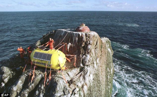
In 1997, the environmentalist organisation Greenpeace occupied the islet for a short time, calling it Waveland, to protest against oil exploration. Greenpeace declared the island to be a "new Global State" (in this case qualifying it as a micronation) and offered citizenship to anyone willing to take their pledge of allegiance. The British Government's response was to state that "anyone is free to go there" and otherwise ignore them. During his one night on Rockall, Greenpeace protester and Guardian journalist John Vidal unscrewed the 1955 plaque and re-fixed it back-to-front.
In 2010, it was revealed that the plaque had gone missing. An Englishman, Andy Strangeway, announced his intention to land on the island and affix a replacement plaque in June 2010. The Western Isles Council have approved planning permission for the plaque. The 2010 expedition was cancelled, but Strangeway still intends to replace the plaque.
In 2013 an occupation of the island by explorer Nick Hancock to raise money for the charity Help for Heroes was planned. The challenge was to land on Rockall and survive solo for 60 days. On 31 May 2013, Hancock, and a TV crew from The One Show, sailed to the islet aboard the Orca III, and he made his first unsuccessful attempt to land on the islet. The weather conditions at the time "were not favourable" according to a Maritime and Coastguard Agency official. Subsequently, Hancock postponed his challenge until 2014. On 5 June 2014 Hancock successfully landed on Rockall to begin his 60-day survival. Despite being forced to cut his 60-day goal short after losing supplies in a storm, Hancock did remain on the island for 45 days (beating McClean's occupancy record by five days).
The "Round Rockall" sailing race, sponsored by Galway Bay Sailing Club, runs from Galway, Ireland, around Rockall and back. It was held in 2012 to coincide with the finish of the 2011–12 Volvo Ocean Race around the world.
The 2015-2016 Clipper Round the World Yacht Race race 12 from New York to Londonderry was extended around Rockall despite previous promises to crew from Sir Robin Knox-Johnston that this would not happen again after the race to Danang.
United Kingdom
The UK claims Rockall along with a 12-nautical-mile (22 km; 14 mi) territorial sea around the islet inside the country's exclusive economic zone (EEZ). The UK also claims "a circle of UK sovereign airspace over the islet of Rockall".
The UK annexed Rockall on 18 September 1955 when "Two Royal Marines and a civilian naturalist, led by Royal Navy officer Lieutenant Commander Desmond Scott, raised a Union flag on the island and cemented a plaque into the rock". In 1972, the British Island of Rockall Act formally annexed Rockall to the United Kingdom. The UK considers the island administratively part of the Isle of Harris and, under the Scottish Adjacent Waters Boundaries Order 1999 a large sea area around it was declared to be under the jurisdiction of Scots law. A navigational beacon was installed on the island in 1982 and the UK declared that no ship would be allowed within a 50-mile (80 km) radius of the rock. However, in 1997, the UK ratified the United Nations Convention on the Law of the Sea (UNCLOS), limiting territorial sea claims to a 12-nautical-mile, or 14 mile (22 km), radius, and therefore allowing free passage in waters beyond this.
A territorial claim could form the basis for an extended EEZ. However, in 1988, the United Kingdom and Ireland signed an EEZ boundary agreement for which "the location of Rockall was irrelevant to the determination of the boundary". In 1997, the UK ratified UNCLOS, which states that "Rocks which cannot sustain human habitation or economic life of their own shall have no exclusive economic zone or continental shelf".
As the rock lies within the United Kingdom's EEZ, the UK has exclusive rights and obligations in relation to the exploitation, conservation and management of the rock itself.
Ireland
Irish claims to Rockall have been based on its proximity to the Irish mainland, however the country has never formally claimed sovereignty over the rock. Ireland formally rejected the British territorial claim to Rockall, "which would be the basis for a claim to a 12-mile territorial sea".
Ireland regards Rockall as irrelevant when determining the boundaries of the Exclusive Economic Zones (EEZ) as the rock is uninhabitable. In signing the United Nations Convention on the Law of the Sea (UNCLOS) in 1997, the UK has agreed that "Rocks which cannot sustain human habitation or economic life of their own shall have no exclusive economic zone or continental shelf".
In 1988, Ireland and the United Kingdom signed an EEZ boundary agreement, ignoring the rock per UNCLOS. With effect from 31 March 2014, the UK and Ireland published EEZ limits which include Rockall within the UK's EEZ.
In October 2012, the Irish Independent published a picture of the Irish Navy ship Róisín sailing past Rockall conducting routine maritime security patrols, and claimed that it was exercising Ireland's sovereign rights over the rock. In 2014 the OSI survey of Irish Territorial waters included the Rockall bank.
Shipping disasters
There have been various disasters on the neighbouring Hasselwood Rock and Helen's Reef (the latter was named in 1830).