
Designated 9 March 1998 | Salinity 31.31–33.99 psu | |
 | ||
Basin countries | ||
The newry canal from lough neagh to carlingford lough
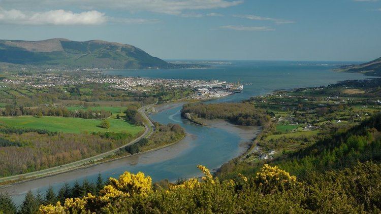
Carlingford Lough (Irish: Loch Cairlinn; Ulster Scots: Carlinford Loch or Cairlinfurd Loch) is a glacial fjord or sea inlet that forms part of the border between Northern Ireland to the north and the Republic of Ireland to the south. On its northern shore is County Down and on its southern shore is County Louth. At its extreme interior angle (the northwest corner) it is fed by the Newry River and the Newry Canal.
Contents
- The newry canal from lough neagh to carlingford lough
- Map of Carlingford Lough
- Columbia clec 2010 carlingford lough endurance challenge
- Geography
- Tourism
- Flora and fauna
- Protected areas
- Railway access
- References
Map of Carlingford Lough
The name is derived from the Old Norse Kerlingfjǫrðr, which means "narrow sea-inlet of the hag". Historically it was called Cuan Snámh-Aighneach, Snámh-Aighneach or Cuan Cairlinne in Irish. An older English name was Nury (Newry) Bay.
Columbia clec 2010 carlingford lough endurance challenge
Geography
The Newry River and the Newry Canal link the lough to the nearby city of Newry (the canal continues on towards the River Bann and Lough Neagh; the river, under the name River Clanrye, loops around County Down). The only other glacial fjords in Ireland are Lough Swilly and Killary Harbour.
On the northern coast, in County Down, are the coastal towns of Warrenpoint and Rostrevor, backed by the Mourne Mountains. On the southern coast are Omeath, Carlingford and Greenore backed by the Cooley Mountains, all on the Cooley Peninsula in County Louth.
The seaward entrance to the lough is marked by the Haulbowline Lighthouse, which was built in 1824.
Tourism
The area has been a popular tourist destination since Victorian times when the railway between Dublin and Belfast was opened. Situated approximately halfway between the two cities, the easy access to the area combined with its scenery and sheltered location are still important factors in its popularity today.
This is where the "Mountains of Mourne sweep down to the Sea"' and together with the Sleve Foy ridge on the County Louth shore of the lough they offer scenic drives, forest parks and many miles of good footpaths and trails to explore. Rambling, hillwalking and climbing are popular, with local outdoor education centres offering courses and activity holidays. It's a similar story on the water, with marinas in Carlingford and Warrenpoint. Craft of various types can be hired at both locations, or the visitor can take a cruise on one of several tour vessels that operate from Omeath, Warrenpoint and Carlingford during the peak season of June, July and August.
Culturally, there is a varied offering of events and festivals. Highlights include the International Blues on the Bay Festival at the end of May in Warrenpoint, Carlingford Oyster Festival, Newry Arts Festival, The "Maiden of the Mournes" in Warrenpoint, Rostrevor's "Fiddlers Green International Folk Festival"' and the Mourne Walking Festival which involves a wide programme of events at a variety of locations. The majority of these festivals are free, although bookings and or entry fees may be payable for some events. More informal entertainment is widely available throughout the year in hotels and bars.
Accommodation includes award-winning hotels, B&Bs, self-catering holiday cottages, and campsites. Early booking is always advisable during holiday periods as even the campsites are often full to capacity. Opportunities to eat out are largely confined to the Hotels, small restaurants and local bars (although many smaller bars do not serve meals), but there is generally a good balance between quality and value for money.
In 2008, the area was designated a European Destination of Excellence (EDEN), and continuing investment in infrastructure, services and facilities on both sides of the border is assured.
Flora and fauna
The northern shores have extensive mudflats and salt marshes which provide winter feeding areas for the pale-bellied brent goose (Branta bernicla hrota). At the mouth of the lough are several small rock and shingle islands which are breeding areas for terns that feed in its shallow waters.
Protected areas
The Lough is an Important Bird Area.
The Carlingford Lough Ramsar site (wetlands of international importance designated under the Ramsar Convention), is 830.51 hectares in area, at latitude 54 03 00 N and longitude 06 07 00 W. It was designated a Ramsar site on 9 March 1998. It is a cross-border site. The northern shore is in Northern Ireland and includes the most significant mudflats in the lough, and an area of salt marsh. The southern shore is in the Republic of Ireland. At the mouth of the lough are several small rock and shingle islands which are of importance to terns. The Ramsar Site lies between Killowen Point and Soldiers Point on the northern shores of Carlingford Lough and the landward boundary coincides entirely with that of the Carlingford Lough Area of Special Scientific Interest and the Carlingford Lough Special Protection Area.
The site qualified under Criterion 2 of the Ramsar Convention because it supports important groups of vulnerable and endangered Irish Red Data Book bird species. It supports nationally important breeding populations of common tern. Roseate terns returned to the site after an absence of six years with two breeding pairs recorded in 1997. It has also supported nationally important numbers of Arctic tern. It also qualified under Criterion 3c for supporting internationally important breeding populations of Sandwich tern and of overwintering light-bellied brent geese.
Railway access
Newry is the nearest station located on the Dublin-Belfast railway line with trains running on the Enterprise between Belfast Central, Portadown and Dublin Connolly, whilst other trains may call at additional stations en route to Belfast Great Victoria Street.