
Peak Benbaun Elevation 729 m Province Connacht | Provinces of Ireland Connacht Highest point Benbaun Country Republic of Ireland | |
 | ||
Mountains Benbaun, Bencorr, Benbrack, Benlettery, Binn Dubh Similar Connemara, Kyle Abbey, Benbaun, Diamond Hill, Mweelrea | ||
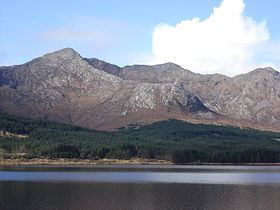
The Twelve Bens, or Twelve Pins (Irish: Na Beanna Beola), is a mountain range of sharp-peaked quartzite ranges located northeast of Roundstone in Connemara in the west of Ireland. Dedicated fell runners attempt to hike all twelve peaks in a single day. Topographically, this range is partnered with the Maumturks range on the other side of the lonely Glen Inagh (and the route of Western Way long distance path). Frequent rainfall and steep-sided mountains produce an abundance of small trickles and streams which descend into wide-bottomed valleys below the Twelve Pins to join larger streams with riffles and pools. The highest point in the Twelve Bens is Benbaun at 729 metres (2,392 ft). They provide excellent walking and climbing opportunities for outdoor enthusiasts.
Contents
Map of The Twelve Pins, Glencoaghan, Co. Galway, Ireland
Highest pointsEdit
The following table lists the 12 highest major mountain peaks of the Twelve Bens Mountains, all with a topographic elevation of at least 516 metres (1,693 ft). There are a number of mountains higher than Benglenisky, but do not have sufficient prominence to be included in this list.
Other projectsEdit
Media related to Twelve Bens at Wikimedia Commons