
Basin area 2,530 km² | Length 140 km Basin area 977 km² Bridges Green's Bridge | |
 | ||
- average 42.9 m/s (1,515 cu ft/s) | ||
The River Nore (Irish: An Fheoir) is a 140-kilometre (87 mi) long river located in south-east of Ireland. Along with the River Suir and River Barrow, it is one of the constituent rivers of the group known as the Three Sisters. The river drains approximately 977 square miles (2,530 km2) of Leinster. The long term average flow rate of the River Nore is 42.9 cubic metres per second (m3/s) The river rises in the Devil's Bit Mountain, County Tipperary. Flowing generally southeast, and then south, before emptying into the Celtic Sea at Waterford Harbour, Waterford.
Contents
Map of River Nore, Ireland
Parts of the river are listed as Special Areas of Conservation.
NameEdit
The river is known in Irish as An Fheoir [ənˠ oːɾʲ], possibly referring to féar, "grass." In 1732 John Loveday spelled it Neor and Neure.
CourseEdit
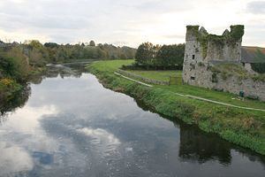
The Nore rises on the eastern slopes of the Devil's Bit Mountain in the townland of Borrisnoe, County Tipperary. It then flows south-eastwards to County Laois and County Kilkenny before joining the River Barrow just north of New Ross near the Barrow Bridge. The river passes near Durrow, County Laois then through Ballyragget, the city of Kilkenny and then the villages of Bennettsbridge and Thomastown. It flows through the Mount Juliet estate. Further south, it forms a picturesque V-shaped river valley, particularly notable near the village of Inistioge, the tidal limit. Major tributaries of the Nore include the Dinan, the Breagagh at Kilkenny City, the King's River, the Little Arrigle and the Black Water.
List of places along the river.
List of tributaries
GeologyEdit
It rises on a sandstone base but the catchment soon turns to limestone and remains so to the sea. The countryside is one of mixed farming, with some tillage, quite a bit of pasture and dairying and some bloodstock. The river has a fairly steep gradient but the flow is checked by innumerable weirs and it is probably true to say that shallow glides are the pre-dominant feature.
HistoryEdit
In pre-Famine years, many water powered industries existed in the Nore valley, particularly in the ten mile (16 km) stretch between Kilkenny City and Thomastown; breweries, woolen mills, sawmills, marble works, distillaries and grain mills. Flax and linen were also produced just north of Kilkenny City.
RecreationEdit
Kilkenny fishing club has extensive fishing rights on the River Nore and its tributary, the River Dinan. Popular with anglers, it holds brown trout and salmon.
Some of these weirs along the river have good playboating qualities. The river is long and mostly flat and dotted with weirs at most of the villages it passes through.
Salmon runs on the river Nore were interrupted in 2005 and 2006 by a flood relief scheme in Kilkenny city carried out by the Office of Public Works. Initially budgeted at €13.1 million, the scheme was delivered at a cost in excess of €48 million and did not contain suitable fish passes. This oversight has since been rectified at additional expense and salmon can now ascend the river upstream of Kilkenny city.