
Characteristic Fl (2) W 10 s. Focal height 72 m Range 37,040 m | Construction masonry tower Fog signal 3 blasts every 45 s Height 30 m Year first constructed 1853 | |
 | ||
Tower shape cylindrical tower with balcony and lantern Markings / pattern white and black horizontal bands Similar Charles Fort, Desmond Castle, Mizen Head, James's Fort, Royal County Down Gol | ||
Flight at the old head of kinsale cork ireland
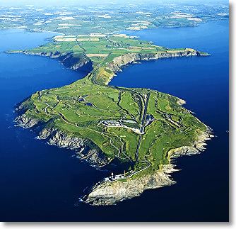
The Old Head of Kinsale (in Irish, An Seancheann) is a headland near Kinsale, County Cork, Ireland. An early lighthouse was established here in the 17th century by Robert Reading. The area is the nearest point of land (11 miles/18 km) to where the RMS Lusitania was sunk in 1915.
Contents
- Flight at the old head of kinsale cork ireland
- Map of Old Head of Kinsale Downmacpatrick Co Cork Ireland
- Walking the old head of kinsale southern ireland county cork selfie walk view cliffs coast
- Geographical Information
- Protests
- References
Map of Old Head of Kinsale, Downmacpatrick, Co. Cork, Ireland
Today the Old Head of Kinsale is popular with golfers who come to play on its 18 Hole golf course that opened in 1997.
Walking the old head of kinsale southern ireland county cork selfie walk view cliffs coast
Geographical Information
The old head of Kinsale was formed by differential erosion. An outcrop of hard sandstone is lodged between two layers of shale. The shale is eroded by marine action at a faster rate than the sandstone. The sandstone anticlines were much more resistant to erosion than the slate filled synclines. Thus over time the headland was formed.
Protests
Since the golf course opened, access to the Old Head of Kinsale has been restricted to golfers and guests only, and there has been a long-running campaign for the restoration of public access organised by the Free the Old Head of Kinsale Campaign. This campaign has mainly taken the format of "People's Picnics", some of them involving "incursions" onto the headland and holding the picnics at the Old Head lighthouse.