
Continent Antarctica Borders No land boundaries | Coastline 17,968 km (11,165 mi) | |
 | ||
Area Ranked 2nd (unofficially) Lowest point Bentley Subglacial Trench, −2,555 m (−8,382.5 ft) | ||
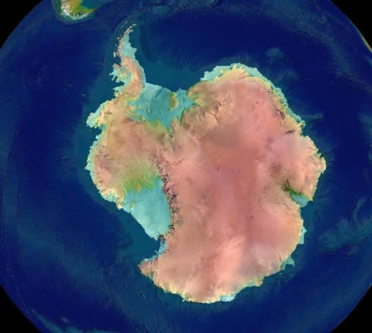
The geography of Antarctica is dominated by its south polar location and, thus, by ice. The Antarctic continent, located in the Earth's southern hemisphere, is centered asymmetrically around the South Pole and largely south of the Antarctic Circle. It is washed by the Southern (or Antarctic) Ocean or, depending on definition, the southern Pacific, Atlantic, and Indian Oceans. It has an area of more than 14 million km².
Contents
- Regions
- Volcanoes
- West Antarctica
- Areas
- Seas
- Ice shelfs
- Islands
- East Antarctica
- Territorial landclaims
- Dependences and territories
- References
Some 98% of Antarctica is covered by the Antarctic ice sheet, the world's largest ice sheet and also its largest reservoir of fresh water. Averaging at least 1.6 km thick, the ice is so massive that it has depressed the continental bedrock in some areas more than 2.5 km below sea level; subglacial lakes of liquid water also occur (e.g., Lake Vostok). Ice shelves and rises populate the ice sheet on the periphery.
Regions
Physically, Antarctica is divided in two by Transantarctic Mountains close to the neck between the Ross Sea and the Weddell Sea. Western Antarctica and Eastern Antarctica correspond roughly to the eastern and western hemispheres relative to the Greenwich meridian. This usage has been regarded as Eurocentric by some, and the alternative terms Lesser Antarctica and Greater Antarctica (respectively) are sometimes preferred.
Lesser Antarctica is covered by the West Antarctic Ice Sheet. There has been some concern about this ice sheet, because there is a small chance that it will collapse. If it does, ocean levels would rise by a few metres in a very short period of time.
Volcanoes
There are four volcanoes on the mainland of Antarctica that are considered to be active on the basis of observed fumarolic activity or "recent" tephra deposits: Mount Melbourne (2,730 m) (74°21'S., 164°42'E.), a stratovolcano; Mount Berlin (3,500 m) (76°03'S., 135°52'W.), a stratovolcano; Mount Kauffman (2,365 m) (75°37'S., 132°25'W.), a stratovolcano; and Mount Hampton (3,325 m) (76°29'S., 125°48'W.), a volcanic caldera.
Several volcanoes on offshore islands have records of historic activity. Mount Erebus (3,795 m), a stratovolcano on Ross Island with 10 known eruptions and 1 suspected eruption. On the opposite side of the continent, Deception Island (62°57'S., 60°38'W.), a volcanic caldera with 10 known and 4 suspected eruptions, have been the most active. Buckle Island in the Balleny Islands (66°50'S., 163°12'E.), Penguin Island (62°06'S., 57°54'W.), Paulet Island (63°35'S., 55°47'W.), and Lindenberg Island (64°55'S., 59°40'W.) are also considered to be active.
West Antarctica
West Antarctica is the smaller part of the continent, divided into:
Areas
Seas
Ice shelfs
Larger ice shelfs are:
For all ice shelfs see List of Antarctic ice shelves.
Islands
For a list of all Antarctic islands see List of Antarctic and sub-Antarctic islands.
East Antarctica
East Antarctica is the larger part of the continent, both the South Magnetic Pole and geographic South Pole are situated here. Divided into:
Areas
Seas
Ice shelfs
Larger ice shelfs are:
For all ice shelfs see List of Antarctic ice shelves.
Islands
For a list of all Antarctic islands see List of Antarctic and sub-Antarctic islands.
Territorial landclaims
Seven nations have made official Territorial claims in Antarctica.